
Regulations Amending the Metal and Diamond Mining Effluent Regulations: SOR/2018-219
Canada Gazette, Part II, Volume 152, Number 23
Registration
SOR/2018-219 October 29, 2018
FISHERIES ACT
P.C. 2018-1316 October 26, 2018
Her Excellency the Governor General in Council, on the recommendation of the Minister of the Environment, pursuant to subsection 36(5) of the Fisheries Act footnote a, makes the annexed Regulations Amending the Metal and Diamond Mining Effluent Regulations.
Regulations Amending the Metal and Diamond Mining Effluent Regulations
Amendments
1 The portion of item 41 of Schedule 2 to the French version of the Metal Mining and Diamond Effluent Regulations footnote 1 in column 2 is replaced by the following:
| Item |
Column 2 |
|---|---|
41 |
Le cours d’eau sans nom qui est composé de ruisseaux et d’étangs interconnectés, qui est tributaire de la rivière Hall et qui est situé à environ 15 km au nord-ouest de la ville de Sept-Îles, au Québec. Plus précisément, la partie du cours d’eau sans nom qui s’étend sur 910 m en aval du point situé par 50°14′52,33″ de latitude N. et 66°33′27,75″ de longitude O. jusqu’au point situé par 50°14′39,67″ de latitude N. et 66°32′45,74″ de longitude O. et qui couvre une superficie de 3,619 ha. |
2 Schedule 2 to the Regulations is amended by adding the following after item 42:
| Item |
Column 1 |
Column 2 |
|---|---|---|
43 |
Davidson Lake, Ontario |
Davidson Lake, located at 47°56′0.3″ north latitude and 80°42′52.68″ west longitude, approximately 3 km west of the township of Matachewan, Ontario. |
Coming into Force
3 These Regulations come into force on the day on which they are registered.
REGULATORY IMPACT ANALYSIS STATEMENT
(This statement is not part of the Regulations.)
Issues
Amendment associated with Young-Davidson Mine
Alamos Gold Inc. (Alamos) owns and operates the Young-Davidson mine in northern Ontario, an underground and open-pit mine located approximately 2 kilometres (km) west of the township of Matachewan and approximately 80 km southeast of Timmins.
The Young-Davidson Mine is a brownfield site that was redeveloped at the former site of two mines, Matachewan Consolidated and Young-Davidson, and achieved commercial production in 2012. Alamos intends to expand its mineral reserves, which will add approximately 18 years to the mine life. The existing tailing impoundment area (TIA) does not have the capacity to store the additional tailings that will be generated from the mine expansion.
To overcome the tailings storage capacity shortfall, Alamos proposes the development of a new TIA that will overprint Davidson Lake, which was historically used for the disposal of tailings from 1934 to 1956, and has renaturalized over the years, and is now frequented by fish. Subsection 36(3) of the Fisheries Act (FA) prohibits the deposit of deleterious substances into waters frequented by fish, unless authorized by Regulations. The Metal and Diamond Mining Effluent Regulations (MDMER or the Regulations), made pursuant to subsection 36(5) of the Fisheries Act, include provisions to allow the use of waters frequented by fish for the disposal of mine waste. The Amendment to the MDMER adds one water body to Schedule 2 of the Regulations, designating it as a TIA, therefore allowing Alamos to store tailings as proposed.
Revision from the Standing Joint Committee for the Scrutiny of Regulations related to item 41 of Schedule 2 of the MDMER (SOR/2018-100, Arnaud Mine Project)
The Standing Joint Committee for the Scrutiny of the Regulations (SJCSR) noted a discrepancy between the English and French versions of item 41 of Schedule 2 of the MDMER, following an amendment to the MDMER published in the Canada Gazette, Part II, on May 30, 2018. The English version identifies a portion of the unnamed watercourse extending downstream from a point, but the French version identifies a portion of the unnamed watercourse extending upstream (“en amont”) from the same point. The Amendment corrects the French version of item 41 on Schedule 2 of the MDMER to address this issue.
Background
Metal and Diamond Mining Effluent Regulations
The MDMER, which came into force on June 1, 2018, as an amendment to the December 6, 2002, Metal Mining Effluent Regulations, prescribe the maximum authorized limits for deleterious substances in metal mine effluent in Schedule 4 (e.g. arsenic, copper, cyanide, lead, nickel, zinc, radium-226 and total suspended solids). The Regulations also specify the allowable acidity or alkalinity (pH range) of mine effluent and require that mine effluent not be acutely lethal to fish. footnote 2 The MDMER further require that mine owners or operators sample and monitor effluents to ensure compliance with the authorized limits and to determine any impact on fish, fish habitat and fishery resources. The Department of the Environment publishes annual performance summaries for metal mines for selected standards prescribed by the MDMER.
The MDMER also include provisions to authorize the use of water bodies frequented by fish for mine waste disposal. This can only be authorized through an amendment to the MDMER, in which case the water body will be listed in Schedule 2 of the Regulations, designating it as a TIA. As of June 2018, 42 water bodies were listed in Schedule 2.
The proponent must demonstrate that the disposal of mine waste in water body frequented by fish is the most appropriate option from an environmental, technical and socio-economic perspective.
When a fish-frequented water body is added to Schedule 2 of the MDMER, section 27.1 of the Regulations requires the development and implementation of a fish habitat compensation plan (FHCP) to offset the loss of fish habitat that will occur as a result of the use of a fish-frequented water body for mine waste disposal. The owner or operator of a mine is also required to present an irrevocable letter of credit to ensure that funds are in place to address all elements of the fish habitat compensation plan.
The Young-Davidson mine expansion project
The Young-Davidson mine is an operating underground and open-pit gold mine located in northeastern Ontario approximately 2 km west of the township of Matachewan. The Young-Davidson mine was a brownfield site that was redeveloped at the former site of two mines, Matachewan Consolidated and Young-Davidson, and achieved commercial production in 2012. The mineral exploration program at the mine site has resulted in the expansion of the mineral reserves. The operating life of the mine is estimated to be extended by 18 years. Alamos is proposing the development of a new TIA to manage mine waste resulting from this expansion and the creation of new associated infrastructure (i.e. access road, pipeline corridor).
The mine employs approximately 700 people, including direct company employees (approximately 600) and contractors (approximately 100). An estimated 80% of the work force resides locally (i.e. within a distance of approximately 100 km) and 12% are First Nation members. Alamos is projecting an investment of over $25 million related to the construction of the project and other associated infrastructure.
Mine waste management for the Young-Davidson mine expansion project
With the proposed expansion, Alamos estimates that 65 million tonnes (Mt) of tailings will be generated over the life of the mine, including ore already processed.
Currently, the mine manages tailings using a combination of deposits into an existing TIA (TIA-7) and using some of the tailings as backfill in the underground mine. Over the life of the mine, the existing TIA can accommodate approximately 20 Mt of tailings, and approximately 20 Mt of tailings can be used in the backfill in the underground workings, including backfill already deposited.
This means there is a tailings storage shortfall of 25 Mt that Alamos proposes to overcome through the development of a new TIA that will destroy Davidson Lake, which was historically used for the disposal of tailings, and that has since re-naturalized and is now frequented by fish. The total area of the water body that is added to Schedule 2 of the MDMER is approximately 22.4 ha. The species that are found therein consist of nine small-bodied fish species footnote 3 and White Sucker footnote 4. To offset this loss of fish habitat, the proponent is required to develop and implement an FHCP.
Environmental assessment of the Young-Davidson mine expansion project
The Canadian Environmental Assessment Agency (the Agency) confirmed that the mine expansion will not cause a change in the production capacity of the mine, and will not increase the area of the mine operations above the 50% threshold, as described in paragraph 17(c) of the schedule to the Regulations Designating Physical Activities. Therefore, the Agency concluded that the mine expansion is not a designated physical activity under the Canadian Environmental Assessment Act, 2012 (CEAA 2012) and is not subject to a federal environmental assessment.
The proposed Young-Davidson mine expansion project was subject to Class Environmental Assessments from the Ontario Government for a work permit, two forestry resource licences, and various land tenure dispositions to support the proposed tailings impoundment area’s development and the road realignment. That process has been successfully completed.
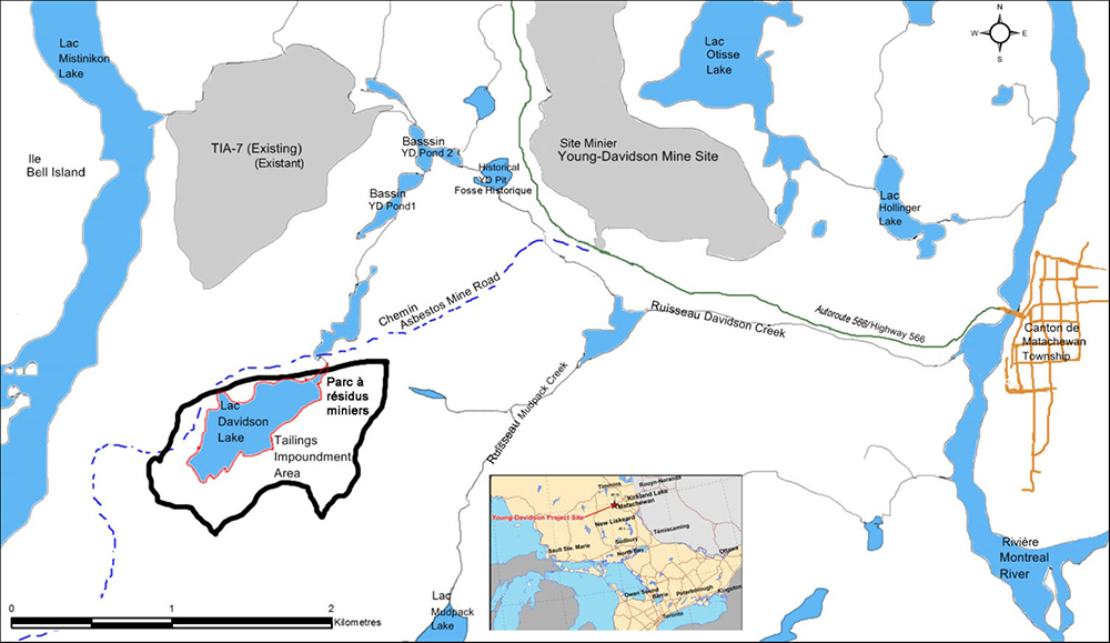
Figure 1: Location of the water body to be listed under Schedule 2 of the MDMER
Objectives
The objective of the Regulations Amending the Metal and Diamond Mining Effluent Regulations is to enable the storage of tailings in one water body frequented by fish that is part of the Young-Davidson mine expansion project, and to correct a discrepancy between the French and English description of item 41 of Schedule 2 of the MDMER.
Description
Amendment
The Amendment adds Davidson Lake, which is located approximately 3 km from the township of Matachewan, Ontario, to Schedule 2 of the MDMER (see Figure 1). The Amendment also amends the French description of item 41 of Schedule 2 to the MDMER.
Fish habitat compensation plan
The FHCP was reviewed and accepted by the Department of Fisheries and Oceans. The measures that will be implemented by the proponent to offset the loss of fish habitat caused by the TIA were developed through discussions with the impacted communities and stakeholders. The proposed measures aim to meet local restoration priorities, would contribute to publicly accessible local baitfish harvest opportunities, and increase the available habitat relative to existing conditions and the production of Walleye, which is a highly valued recreational and sustenance species in the region. The plan comprises several compensatory measures, as follows:
- Development of an estimated 3.72 ha of enhanced baitfish habitat along Davidson Creek, with the emphasis on providing local bait fishing opportunities;
- Restoration and enhancement of a walleye spawning area; removal of a fish barrier at the Matachewan First Nation road crossing of Baptiste Creek where historic fish spawning occurred; and restoration and enhancement of a walleye spawning area at Chief’s Creek, the outlet of Turtle Lake into Baptiste Creek;
- Cleaning and enhancement of three Walleye spawning areas in Lake Temagami, as identified by the Temagami First Nation, the Fish Hatchery members of the Temagami Area Fish Involvement Program, and the Ontario Ministry of Natural Resources and Forestry, North Bay District; and
- Funding scientific research to develop and verify the usefulness of environmental deoxyribonucleic acid (eDNA) footnote 5 metabarcoding for use as an indicator of fish presence and potential abundance of fish species, and its potential application to satisfy regulatory monitoring requirements.
Following an inquiry from a First Nation, Alamos has committed to conduct a fish salvage program to remove fish, to the extent possible, from areas where water bodies are to be overprinted or isolated from the active creek channel (i.e. Davidson Lake and the Davidson Creek enhancement areas) in order to mitigate serious harm to fish. This program is planned to be finalized by the proponent before winter 2019.
Alamos will also implement a monitoring program for the compensation plan in order to ensure the effectiveness of the measures implemented. The plan may be amended to ensure the achievement of the objectives, if this is demonstrated to be necessary based on the monitoring results.
“One-for-One” Rule
The “One-for-One” Rule does not apply to the Regulations, as it will not impose new administrative burden on business.
Small business lens footnote 6
The Amendment does not trigger the small business lens as the owner and operator of the project, Alamos Gold Inc., is not considered a small business.
Consultation
The Department of the Environment held consultations on the proposed Amendment with Indigenous communities, the general public, environmental non-governmental organizations (ENGOs) and other interested parties. The consultations are summarized below.
Consultation prior to the publication of the proposed Amendment in the Canada Gazette, Part I
The project is located within the asserted traditional territories of the Matachewan and the Temagami First Nations, and both were engaged in consultation associated with the proposed Amendment. Departmental officials met with the Chief, a counsellor and the mineral development advisor of the Temagami First Nation on November 7, 2016, and also held sessions on March 16 and April 19, 2017, with the leadership and members of the Matachewan and the Temagami First Nations, respectively. Public consultations were also held on the proposed Amendment in the township of Matachewan, on March 15, 2017. A teleconference took place on March 29, 2017, involving a local ENGO and industry representatives.
The sessions provided an opportunity for stakeholders and Indigenous communities to provide comments on the proposed Amendment, the assessment of alternatives for mine waste disposal report and the proposed FHCP. Each session was followed by a 30-day comment period, and four written submissions were received: one from an ENGO, one from a stakeholder, and two from the First Nations.
On April 10, 2017, the Temagami First Nation submitted a report on its review of the alternative locations for the proposed TIA and the proposed FHCP, and indicated that it supports both the new tailings facility at Davidson Lake and the proposed FHCP.
On October 16, 2017, the Matachewan First Nation issued a letter in which it noted that it had reached an understanding with the proponent regarding how the impacts of the proposed TIA will be managed and mitigated, and that it will continue to work with the proponent to address any remaining concerns. It stated that it seeks no further conditions, reports, engagement or action from the Department of the Environment.
Comments on the proposed Amendment and the assessment of alternatives for tailings disposal
Comment
A community member inquired about the process for evaluating which lakes are added to Schedule 2 of the MDMER for the mine waste disposal.
Response
Departmental officials explained that it evaluates project proposals when there are impacts to water bodies frequented by fish. The proponent submits an assessment of alternatives report that evaluates the options for mine waste disposal, and a proposed FHCP to offset the loss of fish habitat. Officials review the assessment of alternatives report, and the Department of Fisheries and Oceans reviews the proposed FHCP, to ensure compliance with respective policies and guidelines, and with the MDMER.
The Department of the Environment holds consultations with Indigenous groups, stakeholders and the general public, and all comments received are taken into account prior to making a recommendation on the proposed regulatory Amendment.
Comment
A First Nation member inquired about how input from First Nations is incorporated into the process for evaluating which lakes are added to Schedule 2 of the MDMER, and whether there is a mechanism whereby First Nation communities can object to or refuse to accept any decisions made pertaining to Schedule 2 of the MDMER.
Response
Departmental officials responded that input from First Nations is part of the process for evaluating which water bodies would be added to Schedule 2 of the MDMER.
The Department’s Guidelines for the assessment of alternatives for mine waste disposal note that the proponent should engage with Indigenous communities whose interests and rights may be impacted by a project proposal. Matters that must be taken into account include Aboriginal land/mineral use rights, the maintenance of traditional lifestyle, ecological/cultural values, and previous and existing land use (e.g. hunting and fishing). It is the responsibility of the proponent to interface with the local Indigenous communities on these matters and to take traditional knowledge into account as they undertake their assessment.
These factors are all taken into account by the Department during the evaluation of the proponent’s proposal to use a water body frequented by fish for mine waste disposal. The Department of the Environment and the Department of Fisheries and Oceans must both be satisfied that the proponent’s proposal meets their policies and guidelines, including the need to consider the interests and rights of local Indigenous communities during the development of the proposed regulatory Amendment. The Department also undertakes consultations with the local Indigenous communities to obtain their comments on the proposed Amendment, which are taken into account when the regulatory proposal is being drafted. First Nation communities also have the opportunity to provide comments on the proposed Amendment during the 30-day consultation period following the publication in the Canada Gazette, Part I.
Comment
A community member asked about whether an evaluation had been carried out to determine how the proposal will impact the ecosystem.
Response
An Alamos representative responded that during the project development phase in 2008 and again in 2015 to support the development of the new tailings facility and the necessary realignment of the road, a number of baseline studies were carried out to identify the impacted species. These studies included assessments of vegetation community types, plant inventories, bird species, bat surveys and surveys of other wildlife. A focus was placed on species at risk (SAR) as these species are considered potentially vulnerable. No SAR were identified within the proposed TIA footprint, but it was noted that a number of species, such as little brown myotis, northern myotis, bald eagle, peregrine falcon, Canada warbler and common nighthawk occur in the general expansion project area. To mitigate the effects on species identified in the study, it is proposed to develop a compact mine site, to place new developments overtop of previously disturbed sites, and to revegetate exposed tailings beaches following mine closure.
Comment
An ENGO commented that Alamos has provided only brief rationale for excluding certain proposed options for the TIA for further analysis following the pre-screening. The ENGO also noted that the description of Davidson Lake provides a summary description of the environmental, technical, economic and social characteristics. The ENGO went on to say that the characterization of the six options provided in the summary table omits features that would be useful when comparing the options.
Response
Alamos indicated that the assessment of alternatives for mine waste disposal report is intended to provide a summary of the environmental, technical, economic and social characteristics. Further information can be found in the Alamos Gold Inc., Young-Davidson Mine — New Tailings Facility and Road Realignment Environmental Study Report. A copy of the Environmental Study Report can be requested from Alamos Gold Inc. The characterization of the six options can be found in Table 7.1: Alternatives Characterization of the Young-Davidson Mine Assessment of Alternatives for Storage of Mine Waste, July 2016.
Comment
An ENGO noted that the pre-screening condition identified by Alamos Gold Inc., whereby alternatives must be capable of storing the majority of the tailings that will be generated in order to be considered viable, has eliminated the ability to combine storage methods and locations that may result in lesser impacts on the terrestrial and social environment.
Response
Alamos indicated that it is pursuing a combination of tailings disposal in underground mine workings and surface tailings impoundment as described in sections 6.2.1 and 6.2.4 of the assessment of alternatives report to reduce the amount of tailings requiring surface deposition. Multiple locations would have a larger overall footprint, for both the tailings area and access infrastructure, and would also have lower tailings storage to dam volume efficiencies resulting in greater material movement for dam construction. These aspects would increase air, noise and greenhouse gas emissions, as well as the project’s costs.
Comment
An ENGO indicated that it would have been beneficial to engage directly with the communities in the weighting process, since the weighting is a subjective process, and inquired why the environment is weighted more than the other accounts in the multiple accounts analysis.
Response
Alamos responded that the weighting process needs to consider a variety of factors and interests, using best professional judgment from the collective assessment team, the members of which are intimately familiar with the varying aspects of the project and surrounding area. There were considerable discussions among team members to derive the final weighting factors and, ultimately, reviewers are free to comment on the weighting factors that have been developed during discussions with the community environmental committees and during consultations.
A departmental official responded that as part of the multiple accounts analysis presented in the assessment of alternatives, a base case is done where the environment is assigned a higher weighting than the other accounts as outlined in the Guidelines for the assessment of alternatives for mine waste disposal. The weightings assigned to the indicators should also be based on input from stakeholders and First Nations.
Comment
A local cottager and an ENGO commented on the assessment of alternatives report that states the proposed TIA will be located over a historic tailings site (Davidson Lake), and that the site has re-naturalized over time and fish are now present. However, Alamos Gold Inc. has not remediated existing damages to land and water bodies at the mine site during the last 10 years of operation. Another stakeholder remarked that the proposed TIA is in fact still impacting untouched habitat, as are the other options.
Response
Alamos indicated that Davidson Lake has substantially naturalized since tailings deposition ceased in the mid-1950s and has been colonized by a forage fish community due in large part to the benign (non-acid generating/nonmetal leaching) nature of the deposited tailings. The exposed tailings beaches adjacent to the lake have experienced only limited natural recolonization by plant species due in large measure to the limited organic nutrient content of the beaches. Alamos added that the Closure Plan for the Young-Davidson Mine site and the materials to support the proposed amendment to the plan describe the proposed mine site remediation activities that include the rehabilitation of all mine-related disturbed areas at the site and the provision of financial assurance. This will include the existing TIA and the proposed TIA, as well as the open pit and other mine site facilities.
Alamos indicated that one option carried forward for the multiple accounts analysis involved using on-land deposit of tailings, which would not have impacted fish-frequented water bodies. However, the option that scored the best based on the environmental, technical and socioeconomic perspectives considered in the multiple accounts analysis is Davidson Lake.
Comment
A stakeholder commented that Alamos is not maintaining a distance of 1 000 m between the proposed TIA and the cottages, which in their view does not meet the township of Matachewan’s Official Plan (2015) for activities that are defined as “incompatible uses.”
Response
Alamos indicated that the Environmental Study Report (ESR) that was prepared to support the Ontario Class Environmental Assessment Processes is a detailed study that considers the adverse effects to adjacent sensitive land uses. The ESR was shared with the township of Matachewan, and public open houses were attended by township representatives. With respect to mineral mining in rural areas, Section 3.4.3 of the Draft Township of Matachewan Official Plan (Draft of May 1, 2015) identifies mining and mining-related uses and structures associated with mining as permitted uses. The ESR meets the requirements of the Plan, which states, “Development proposals will be considered based on studies of compatibility, environmental impact studies, groundwater, noise, dust, vibration, and other appropriate matters.”
Comment
A local cottager and an ENGO have identified potential exposure to noise from construction, potential exposure to dust, potential loss in property value and a potential risk of dam failure as concerns associated with the preferred option for the tailings impoundment area. Some stakeholders asked for further details related to the noise study that Alamos will undertake and the associated action plan.
Response
Alamos indicated that with regard to dust emissions, it has committed to an air quality monitoring plan that will involve visual surveillance of dust conditions and the timely application of water sprays from a watering truck. With regard to property values, Alamos indicated that the company has committed to appropriate mitigation, monitoring and closure conditions to minimize potential short- and long-term impacts. With regard to the potential for a tailings dam failure, the tailings dams will be designed and constructed to meet the requirements of the provincial Lakes and Rivers Improvement Act (R.S.O. 1990, c. L.3), including contingency plans in the event of dam failure.
With regard to noise from construction of the proposed TIA, Alamos indicated that the assessment of noise effects to off-property receptors in Ontario is governed by the Environmental Noise Guideline – Stationary and Transportation Sources – Approval and Planning Publication NPC-300 (Ministry of the Environment of Ontario — MOE 2013). The guideline’s exclusionary sound limit values specifically exclude application to construction activities, but Alamos has made a commitment to manage construction noise in a responsible manner to limit the potential for infringement on nearby residences.
Alamos indicated that the company has undertaken or is committed to undertaking mitigation measures, as documented in Section 6.4 of the Environmental Study Report (Amec Foster Wheeler 2017). This commitment includes the selection of a TIA site that provides maximum natural containment to reduce the extent and duration of construction activities, making best efforts to maintain the current buffer of tree growth between the proposed TIA and Mistinikon Lake cottage lots, providing a further setback, from the original design, of approximately 200 m for the proposed TIA’s west dam from Mistinikon Lake, optimizing construction timing, and implementing a noise monitoring program.
Alamos indicated that noise monitoring will occur at two locations, one in proximity of the south cluster of Mistinikon Lake cottages west of the proposed TIA, and the other on Bell Island west of the boat launch area near existing TIA-7. Baseline monitoring at these sites was undertaken from July 5 to 11, 2017. Noise monitoring during construction would occur during the two initial summer periods when the proposed TIA is being constructed and two years after for the first TIA dam raise. During those summers, monitoring will be undertaken during two periods: the first in early summer and the second in mid-to-late summer. The need for continued noise monitoring after the first dam raise will be determined from the monitoring results obtained, in consultation with cottage owners at Mistinikon Lake.
If noise levels due to construction-related activities should exceed the guideline’s exclusionary sound limit values, Alamos will consider measures to further reduce sound emissions. The company will ensure that the vehicles are maintained in good working order, determine if modifications can be made to higher sound source equipment, optimize the scheduling of activities, and replace acoustic back-up beepers with visual back-up signals.
Comments on the fish habitat compensation plan
Comment
A member of the public and a stakeholder commented that two of the proposed measures in the FHCP, Lake Temagami and Baptiste Creek, are located a significant distance from Davidson Lake. A stakeholder also asked why fish habitat enhancement was not planned to occur in Mistinikon Lake (immediately west of the current and proposed TIA).
Response
The Department of Fisheries and Oceans responded that the Temagami First Nation and Matachewan First Nation each traditionally use the land that includes Davidson Lake and the Young-Davidson Mine, and indicated that they have been consulted on the potential impacts and offsetting measures associated with the development of a new TIA. The Temagami First Nation indicated that fish habitat enhancement in Lake Temagami was a local restoration priority. Similarly, the Matachewan First Nation indicated that enhancements at Baptiste Creek were a local restoration priority. Although like-for-like offsetting and close-to-impact offsetting are considered as the first options in order to best “balance project impacts” under the Fisheries Productivity Investment Policy: A Proponent’s Guide to Offsetting (Department of Fisheries and Oceans — DFO 2013), this is not always possible. Given that the Policy also includes that offsetting measures must support fisheries management objectives or local restoration priorities, the Department of Fisheries and Oceans concluded that an appropriate balance has been struck through the various measures laid out in the proposed compensation plan. Through discussions with the Ontario Ministry of Natural Resources and Forestry, no impediment to Mistinikon Lake was identified. There is a generally robust Walleye population in that lake; therefore, no potential for direct fish habitat enhancement that aligns with the objectives described in Fisheries Productivity Investment Policy: A Proponent’s Guide to Offsetting could be identified.
Comment
An ENGO commented that further information is required to support the claim that bait fishing opportunities accessed through the recreational trail at Davidson Creek will lead to improved access to the area in contrast to road-based access that is currently available at Davidson Lake. In addition, a stakeholder inquired as to the possibility to access the Davidson Creek area via the existing access road on the eastern edge of the gravel pit, which approaches the enlarged area of Davidson Creek from the south.
Response
An Alamos representative explained that the current access to Davidson Lake is a straight-line distance of 50 m to 100 m from the road through forested lands without defined trails. The Davidson Creek enhancement takes advantage of an existing recreational trail that will enable direct access to the creek. The trail length is 80 m from the road and provides for better walking conditions, and the use of recreational vehicles. The recreational trail will provide access to approximately 250 m of the enhanced Davidson Creek ponded area shoreline.
Further, access to the Davidson Creek area from the east side via the current access road near the pit area will remain available. The existing road is expected to remain open to use by the public to access baitfish locations along the creek. At times, access may be restricted for safety reasons during periods of active aggregate extraction.
Comment
An ENGO noted that the assessment of alternatives for mine waste disposal report and the proposed FHCP do not address the loss of fish habitat and the flow reductions of Davidson Creek as a result of the impoundment of Davidson Lake. This ENGO also noted that it is not clear how the cumulative impacts of reduced flow to Davidson Creek and the alteration of Davidson Creek for the establishment of baitfish habitat have been considered.
Response
The Department of Fisheries and Oceans reviewed Alamos’s proposal to impound Davidson Lake to determine whether this is likely to cause serious harm to fish, taking into account the size of the impact, the nature of the habitat to be affected, and the mitigation measures that will be implemented to avoid serious harm to fish. The Department of Fisheries and Oceans is of the view that the proposal will not cause serious harm to fish.
Based on the flow regime in upper Davidson Creek, which is dominated by slow moving, impounded water that supports areas of dense vegetation and does not support fish migration between Davidson Creek and Davidson Lake, the Department of Fisheries and Oceans is of the view that reduction of flow in upper Davidson Creek will not result in serious harm to fish. Alamos will be required to implement the mitigation measures as described in the proposed fish habitat compensation plan, including monitoring of the downstream water level, and undertaking fish studies to ensure that impact predictions were accurate.
At the upper reaches of Davidson Creek where flow reduction is expected, the fish species assemblage footnote 7 consists of small-bodied forage fish. These fish do not have a large home range, and would not be expected to be impacted by works occurring at the location where baitfish habitat enhancement is proposed in the furthest reach of Davidson Creek. Likewise, the population of baitfish in the area where the habitat enhancement work is proposed would not be expected to use the area of flow reduction at upper Davidson Creek, and there will be no impact on sportfishing since the affected area does not support sportfish. The Department of Fisheries and Oceans concluded that these concerns will be appropriately addressed through specific mitigation measures and monitoring requirements to be included in the final version of the FHCP (e.g. timing of works, sediment control, fish passage requirements).
Comment
A community member expressed concern relating to aquatic invasive species (AIS) and asked if the prevention of invasive species could be incorporated into the fish habitat compensation plan.
Response
The Department of Fisheries and Oceans explained that the biologists performing the compensation work will be expected to prevent the spread of aquatic invasive species as per best management practices (drain, clean, dry boats and equipment, for example). Although aquatic invasive species are considered to be a serious threat to Canadian fisheries, the primary effort to avoid the spread is education and prevention such as inspection and cleaning of watercraft and equipment. The assessment of the proposed FHCP is based on the four guiding principles considered in the Fisheries Productivity Investment Policy: A Proponent’s Guide to Offsetting (Department of Fisheries and Oceans — DFO 2013). The actions associated with the prevention of AIS do not meet the goals of the fish habitat compensation plan in that they are not selfsustaining and a single work or undertaking will not provide benefits in the long term. Further, in this context, AIS mitigation does not balance project impacts. As per the Aquatic Invasive Species Regulations, it is prohibited to introduce any aquatic species into an area where it is not indigenous without a valid permit or licence. Although these are federal regulations, the management of AIS is delegated to the provincial governments where those governments manage the fishery and these regulations are expanded under provincial law to include a strategic plan, policies or regulations.
Consultations on the proposed Amendment following prepublication in the Canada Gazette, Part I
On May 19, 2018, the proposed Amendment was prepublished in the Canada Gazette, Part I, for a 30-day public comment period. One written submission that includes several comments on the proposed Amendment was received from a local stakeholder. These comments are indicated below.
Some comments made previously were reiterated, notably with respect to the 1 000 m buffer under the 2015 Official Plan and the location of the FHCP that is too far from the impacted areas. Those comments had already been addressed in the “Consultation prior to the publication of the proposed Amendment in the Canada Gazette, Part I” section.
Comment
A local stakeholder had concerns that the Government of Canada authorizes the destruction of the environment and that this authorization will impact property values.
Response
The MDMER include provisions to authorize the use of water frequented by fish for mine waste disposal. This can only be authorized through an amendment to the MDMER, in which case the water body will be listed in Schedule 2 of the Regulations, designating it as a TIA.
The proponent must demonstrate that the disposal of mine waste in water bodies frequented by fish is the most appropriate option from an environmental, technical and socio-economic perspective. Then, section 27.1 of the Regulations requires the development and implementation of an FHCP to offset the loss of fish habitat that occurs as a result of the use of a fish-frequented water body for mine waste disposal. The owner or operator of a mine is also required to present an irrevocable letter of credit to ensure that funds are in place to address all elements of the fish habitat compensation plan.
With regard to property values, Alamos has indicated that the company has committed to appropriate mitigation, monitoring and closure conditions to minimize potential short- and long-term impacts.
Comment
A local stakeholder mentioned that the proponent had already started building roads and infrastructure leading to the proposed TIA before a decision is made on the listing of Davidson Lake to Schedule 2 of the MDMER, which shows that comments from residents are not considered in decision-making by both the proponent and the federal government.
Response
The proponent might require different permits or authorizations for various aspects of the project. The proponent may decide to undertake works required for the mine expansion, such as the development of a road, before a final decision by the Governor in Council is made on the Regulations, if the proponent has received the required permits or authorizations to do so by the relevant jurisdictions.
Comment
A local stakeholder indicated that the new TIA will be the cheapest solution for Alamos, and that allowing the new TIA would be irresponsible.
Response
The proponent prepared an assessment of alternatives report to evaluate options for mine waste disposal. Following the analysis of the different TIA options, the new TIA was found to be one of the two best options from a project economic point of view. Furthermore, the new TIA is also the preferred option from an environmental, technical and socio-economic perspective.
The assessment of alternatives report must demonstrate that the option chosen is the best option for the tailings disposal, taking into account the environmental, technical and socio-economic impacts. The assessment of alternatives report was prepared in accordance with the Department’s Guidelines for the assessment of alternatives for mine waste disposal.
Comment
A local stakeholder requested that more intensive monitoring of pollutant levels in Mistinikon Lake should be made, especially closer to the existing TIA-7. It was also mentioned that the monitoring results were not easily accessible to the public.
Answer
The proponent indicated that there is no effluent water from TIA-7. The effluent water discharge comes from the water treatment plant, underground, and occasionally water pumped from the open pit. The effluent water from the mine water pond is permitted under a provincial authorization. The effluent daily and monthly average concentration limits are outlined in the provincial Environmental Compliance Approval. footnote 8 More rigorous effluent objectives have also been self-imposed at the Young-Davidson Mine.
The proponent is also subject to the MDMER, which prescribe the maximum authorized limits for deleterious substances in mine effluent being deposited into fishfrequented water body, and requires that the mine effluent is not acutely lethal to fish. footnote 9 Furthermore, the MDMER require that mine owners and operators monitor and test mine effluent to ensure compliance with regulated limits.
The proponent indicated that there are several monitoring locations around the TIA-7 for both groundwater and surface water that are permitted provincially for quarterly and monthly sampling respectively. Mistinikon Lake samples are located upstream and downstream of the existing TIA and are analyzed monthly for pH, alkalinity, total suspended solids, cyanide, ammonia, dissolved organic carbon, total and dissolved metals, sulfate, chloride, mercury, calcium, sodium, magnesium, potassium, conductivity, and hardness. Analytical results from these samples are compared to background levels established during baseline studies to determine water quality.
Alamos summarizes monitoring results in quarterly and annual reports submitted to the provincial Ministry of the Environment, Conservation and Parks. Alamos distributes the reports to Matachewan First Nation and Temagami First Nation. Upon request, these reports can be reviewed by members of the public at the Young-Davidson mine site.
Comment
A local stakeholder argued that the proponent did not meet the conditions established in the Environmental Study Report regarding noise related to the new TIA.
Answer
Alamos indicated that noise monitoring will occur at two locations, one in proximity of the south cluster of Mistinikon Lake cottages west of the proposed TIA, and the other on Bell Island west of the boat launch area near existing TIA-7. Initial baseline monitoring at these sites was undertaken from July 5 to 11, 2017. Sound levels at both monitoring locations were consistent with the NPC-300 exclusionary limits for Class 3 areas. footnote 10
Additionally, noise monitoring during construction will occur during the two initial summer periods when the proposed TIA is being constructed and two years after for the first TIA dam raise. During those summers, monitoring will be undertaken during two periods: the first in early summer and the second in mid-to-late summer. The need for continued noise monitoring after the first dam raise will be determined from the monitoring results obtained, in consultation with cottage owners at Mistinikon Lake.
Rationale
Regulatory and non-regulatory options for mine waste disposal
Non-regulatory options include the disposal of mine waste in a manner that will not directly impact water bodies frequented by fish or land-based options. Regulatory options correspond to those that will result in the destruction of a water body frequented by fish.
Alamos carried out an assessment of alternatives to determine the best option for the tailings disposal, taking into account the environmental, technical and socio-economic impacts. This analysis was carried out as per the Guidelines for the assessment of alternatives for mine waste disposal. The report, titled Young-Davidson Mine Assessment of Alternatives for Storage of Mine Waste - Alamos Gold Inc., July 2016, was made public as part of the final Environmental Study Report in January 2017 for the provincial Class EA and was made available to interested parties in advance of the consultation sessions.
Alamos identified nine candidate locations for tailings storage based on engineering studies and the following criteria:
- favourable topography;
- avoiding overprinting protected lands (provincial parks and conservation reserves);
- avoiding displacing or unduly encroaching upon residents and cottagers;
- watershed considerations;
- basin capacity and dam requirements;
- proximity to mine infrastructure; and
- including areas affected by historical mining activities.
Table 1 lists the nine options considered for pre-screening and their relative locations in the area.
Table 1: Options proposed for pre-screening
| Optionstable 1 note 1 |
Approximate Location |
|---|---|
Davidson Lake |
|
Overprints an unnamed tributary. Alternative located south of Davidson Creek, east of Mudpack Creek and west of West Montreal River. |
|
10 |
Located west of Mistinikon Lake and southwest of the mine site. |
11 |
Located east of Sisseney Lake and southeast of the mine site. |
On-land; located south of the mine site and in proximity to Davidson Creek. |
|
13 |
Mudpack Lake |
14 |
Otisse Lake |
15 |
Ryan Lake is located north of the mine site. |
16 |
Hawley Lake is located north of the mine site. |
Table 1 Notes
|
|
Alamos developed pre-screening criteria to identify viable options for tailings storage as follows:
- the ability of the tailings storage method or location to allow impoundment of a significant quantity of tailings;
- the ability of the tailings storage method to provide a substantial benefit over conventional technologies;
- the location is reasonably close to the process plant;
- the location avoids direct impacts to protected lands; and
- the location honours Alamos’s commitments to First Nations for avoidance of culturally sensitive areas.
Options 10 and 11 were screened out based on their relative distance to the mine site and the fact that infrastructure such as roads and pipelines would be located over protected areas such as the West Montreal River Park. Options 13 and 14 were eliminated due to commitments Alamos had made to First Nations to position mine infrastructure away from areas of cultural value. Option 15 is the site of a historic tailings basin owned by another mining company that is active in the area. This alternative cannot contain a sufficient quantity of tailings and would require a large surface impoundment; for these reasons, it was eliminated. Options 15 and 16 were also eliminated due to expressed concerns from First Nations to avoid expansion of the mine site to the north. In addition, Option 16 is a non-impacted lake where sport fish are present.
Options 1, 2 and 12 underwent a detailed characterization as part of the multiple accounts analysis as described in the Guidelines for the assessment of alternatives for mine waste disposal (Department of the Environment, 2013). For the three options, Alamos considered two tailings storage methods, namely conventional slurry and thickened tailings. Following this analysis, depositing conventional slurry at Davidson Lake (Option 1) was identified as the preferred option for the disposal of tailings based on environmental, technical, and socio-economic perspectives.
The preferred option will overprint a water body frequented by fish and therefore requires that Davidson Lake be listed in Schedule 2 of the MDMER.
Analytical framework
The Amendment allows for the listing of Davidson Lake to Schedule 2 of the MDMER so that it can be used for the disposal of tailings from the project.
The analysis below examines the impacts of the Amendment on the environment, Government, and Canadian businesses.
Environmental impacts
The preferred option for the disposal of tailings overprints Davidson Lake, which was historically used as a tailings basin from 1934 to 1956. Since historic mining operations ceased, Davidson Lake has re-naturalized and is now frequented by fish. Fish studies conducted in 2007 and 2015 found that Davidson Lake contains a fish community composed of nine small-bodied fish species footnote 11 and White Sucker. footnote 12 The lake has no defined connectivity with Davidson Creek that would allow for easy fish passage due to the presence of dense vegetation, but an outlet is located on the northeast shoreline of the lake that resulted from a breach through a former tailings dam.
The use of Davidson Lake as a TIA will result in the loss of approximately 22.4 ha of fish habitat. When considering the habitat type and quality that is being impacted and applying site-specific ratios, it is estimated that approximately 17.8 ha of fish habitat will be lost. The loss of fish habitat will be offset by the development and implementation of the proposed FHCP that will result in an estimated fish habitat gain of approximately 20.8 ha.
Following its assessment, the Department of Fisheries and Oceans determined that the compensation plan proposed by Alamos to offset the loss of fish habitat that will result from the TIA is appropriate and meets the guiding principles of the Department of Fisheries and Oceans’ Fisheries Productivity Investment Policy: A Proponent’s Guide to Offsetting.
Costs to Government
The Government of Canada enforcement activities include inspections to monitor the implementation of the fish habitat compensation plan, which may have associated incremental costs. Specifically, there may be incremental site visits, monitoring and review costs incurred by the Department of Fisheries and Oceans. These incremental costs will be low, given that monitoring activities and associated costs will only occur during the implementation of the FHCP, and will not continue throughout the life of the mine waste disposal areas.
Incremental compliance promotion costs will be low, given that the mine is already subject to the MDMER. Therefore, the total incremental costs to the Government associated with the proposed FHCP will be low.
Cost to business
The Amendment will result in additional costs to Alamos associated with the implementation of the fish habitat compensation plan.
Costs attributable to the fish habitat compensation plan, including annual monitoring for 5 years and construction of the proposed compensatory measures, are estimated to $2.43 million (2018 Canadian dollars discounted at a 3% rate). This amount was updated over time to account for uncertainty related to the eDNA study and because more details were requested by the Department of Fisheries and Oceans. The original amount was estimated to be $2.2 million.
Strategic environmental assessment
A strategic environmental assessment was conducted and concluded that authorizing the deposit of mine waste in TIAs will result in adverse environmental effects (i.e. a loss of fish habitat). However, the adverse environmental effects will be offset by the implementation of an FHCP, and it is expected there will be no net loss of fish habitat. Proponents must also submit an irrevocable letter of credit alongside the plan to cover the plan’s implementation costs, including all necessary remedial measures, if the plan’s purpose is not being achieved.
Implementation, enforcement and service standards
The Amendment enables Alamos to use Davidson Lake, a fish-frequented water body, for the disposal of mine waste.
Given that the MDMER are regulations made pursuant to the Fisheries Act, enforcement personnel would, when verifying compliance with the MDMER, act in accordance with the Compliance and enforcement policy for the habitat and pollution provisions of Fisheries Act (the Policy). Verification of compliance with the Regulations and the Fisheries Act would include, among other inspection activities, site visits, sample analysis, review of fish habitat compensation plans and related reports associated with the proposed Amendment.
If there is evidence of an alleged offence of the fisheries protection and pollution prevention provisions of the Fisheries Act and/or related regulations, enforcement personnel would determine an appropriate enforcement action, in accordance with the following criteria, as set out in the Policy:
- nature of the alleged violation;
- effectiveness in achieving the desired result with the alleged violator; and
- consistency in enforcement.
Given the circumstances and subject to the exercise of enforcement and prosecutorial discretion, the following instruments are available to respond to alleged violations:
- warnings;
- directions;
- orders by the Minister;
- injunctions; and
- prosecutions.
For more information on the Policy, please consult the Compliance and enforcement policy for the habitat and pollution provisions of Fisheries Act.
Contact
Nancy Seymour
Manager
Mining and Processing Division
Industrial Sectors, Chemicals and Waste Directorate
Environment and Climate Change Canada
351 Saint-Joseph Boulevard
Gatineau, Quebec
K1A 0H3
Fax: 819-420-7381
Email: ec.mmer-remm.ec@canada.ca