
Regulations Amending the Metal and Diamond Mining Effluent Regulations: SOR/2020-131
Canada Gazette, Part II, Volume 154, Number 14
Registration
SOR/2020-131 June 18, 2020
FISHERIES ACT
P.C. 2020-457 June 17, 2020
Her Excellency the Governor General in Council, on the recommendation of the Minister of the Environment, pursuant to subsection 36(5) of the Fisheries Actfootnote a, makes the annexed Regulations Amending the Metal and Diamond Mining Effluent Regulations.
Regulations Amending the Metal and Diamond Mining Effluent Regulations
Amendment
1 Schedule 2 to the Metal and Diamond Mining Effluent Regulationsfootnote 1 is amended by adding the following in numerical order:
| Item |
Column 1 |
Column 2 |
|---|---|---|
60 |
All waters located within the area described in column 2, located approximately 150 km north of Baker Lake, Nunavut |
The waters located within an area located approximately 150 km north of Baker Lake, Nunavut. More precisely, the area bounded by five straight lines connecting five points starting at the point located at 65°40’45.1" north latitude and 96°67’58.5" west longitude to the point located 778 m to the northwest at 65°41’05.6" north latitude and 96°68’42.2" west longitude to the point located 173 m northeast at 65°41’16.2" north latitude and 96°68’15.2" west longitude to the point located 1050 m southeast at 65°40’60.6" north latitude and 96°66’32.7" west longitude to the point located 168 m southeast at 65°40’45.8" north latitude and 96°66’26.9" west longitude and ending at the point located 611 m west at 65°40’45.1" north latitude and 96°67’58.5" west longitude. |
Coming into Force
2 These Regulations come into force on the day on which they are registered.
REGULATORY IMPACT ANALYSIS STATEMENT
(This statement is not part of the Regulations.)
Executive summary
Issues: Agnico Eagle Mines Limited (the Proponent) is proposing an expansion of its existing Whale Tail Pit Project (the Project), which is located approximately 170 kilometres (km) by road north of the hamlet of Baker Lake in the Kivalliq Region in Nunavut.
The Proponent proposes to construct an attenuation pond and a waste rock storage facility (WRSF), including a groundwater storage pond (GSP), to manage the waste generated by the mining operations (i.e. effluent and waste rock). This approach will impact seven water bodies that are frequented by fish. The Fisheries Act (the Act) prohibits the deposit of deleterious substances in water frequented by fish unless authorized by regulation. The Metal and Diamond Mining Effluent Regulations (MDMER) include provisions to allow for the disposal of mine waste in waters frequented by fish, under certain conditions.
Description: The Regulations Amending the Metal and Diamond Mining Effluent Regulations (the Amendments) will list seven water bodies within a prescribed geographical area (shown in Figure 2), to Schedule 2 of the MDMER, designating them as tailings impoundment areas (TIAs). These seven water bodies will represent a loss of 17.47 hectares (ha) of fish habitat.
Rationale: The Proponent assessed several options to determine the preferred disposal method and site location to manage mine waste,footnote 2 taking into account environmental, technical, economic and socio-economic factors. The Proponent prepared an Assessment of Alternatives Report in accordance with the Department of the Environment’s Guidelines for the assessment of alternatives for mine waste disposal (the Guidelines). Regulatory options include those options that would result in the deposit of mine waste into fish-frequented waters while non-regulatory options include those that do not affect waters frequented by fish (i.e. land-based options).
The site locations for the attenuation pond and the WRSF were selected on the basis of minimizing the environmental impacts of the Project (i.e. smaller disturbed footprint on land) and on the preferences and interests of Inuit communities. The Proponent also considered technical aspects such as dam heights and lengths, and precedents for similar construction in the North.
The MDMER require that the Proponent develop and implement a fish habitat compensation plan (FHCP) to offset the loss of fish habitat resulting from the disposal of mine waste in waters frequented by fish. The Department of Fisheries and Oceans (DFO) determined that the FHCP proposed by the Proponent meets the guiding principles of their Policy for Applying Measures to Offset Adverse Effects on Fish and Fish Habitat Under the Fisheries Act.
The Department of the Environment consulted Indigenous groups as well as the general public and other interested parties that may be adversely impacted by the Project. The Kivalliq Inuit Association (KivIA), an organization that represents the interests of all Inuit living in the Kivalliq Region, sent a letter to the Department of the Environment expressing support for the proposed Amendments and for the streamlining of its approval.
A letter of credit is required from the Proponent to cover the cost of implementation of the FHCP associated with the Amendments, estimated at 1.12 million dollarsfootnote 3 over a ten-year period. The implementation of the FHCP will result in the creation of 20.9 ha of fish habitat, offsetting the loss of fish habitat associated with the listing of the seven water bodies in Schedule 2 of the MDMER as TIAs.
Issues
The Proponent, Agnico Eagle Mines Limited, is proposing to expand its operations at its Whale Tail Pit and to develop an additional open pit and an underground mine. The Proponent proposes to construct an attenuation pond, and a WRSF that will include a GSP to manage the waste rock and effluent generated by the mining operations. The disposal of mine waste will impact seven water bodies frequented by fish.
Subsection 36(3) of the Act prohibits the deposit of deleterious substances into water frequented by fish, unless authorized by regulation. The MDMER, made pursuant to subsections 34(2), 36(5) and 38(9) of the Act, include provisions to allow for the disposal of mine waste in waters frequented by fish, under certain conditions.
Background
Metal and Diamond Mining Effluent Regulations
The MDMER, which came into force on June 1, 2018,footnote 4 prescribe the maximum authorized limits for prescribed deleterious substances in mine effluent in Schedule 4 (e.g. arsenic, copper, cyanide, lead, nickel, zinc, radium-226 and total suspended solids). The MDMER also specify the allowable acidity or alkalinity (pH range) of mine effluent and require that mine effluent not be acutely lethal to fish.footnote 5 The MDMER further require that mine owners and operators sample and monitor effluents to ensure compliance with the prescribed limits and to determine any impact on fish, fish habitat and fishery resources. The Department of the Environment publishes annual performance summaries for metal mines with respect to selected standards prescribed by the MDMER.footnote 6
The use of waters frequented by fish for a mine waste disposal area can only be authorized through an amendment to the MDMER by listing the water body in Schedule 2, designating it as a TIA.
The MDMER requires the development and implementation of an FHCP that meets all the requirements under section 27.1 of the MDMER to offset the loss of fish habitat that would occur as a result of depositing mine waste into a fish-frequented water bodies for mine waste disposal.
Before depositing mine waste into the water bodies that have been added to Schedule 2 of the MDMER, owners and operators of mines must obtain the Minister of the Environment’s approval of the FHCP. The Minister of the Environment must approve the FHCP if it meets the conditions in the MDMER and the owner or operator of a mine has submitted an irrevocable letter of credit to ensure that funds are in place should the owner or operator fail to address all the elements of the FHCP.
For any project where the proposed mine waste disposal would impact fish-frequented waters thus requiring an amendment to Schedule 2 of the MDMER, proponents must consider options for mine waste disposal. They must demonstrate that the preferred option is the best option based on environmental, technical, economic and socio-economic criteria specified in the Guidelines. As part of these guidelines, proponents must also undertake preliminary consultations on how options for mine waste disposal were assessed and how the preferred option was determined.
The Whale Tail Pit Expansion Project
The Proponent began commercial production of gold at the Meadowbank mine in 2010 and expanded operation with the Whale Tail Pit Project (Existing Project) at the Aramuq property in 2018 to produce 8.3 million tonnes (Mt) of ore. The Amaruq property is located approximately 70 km northwest of the Meadowbank Mine and 170 km by road north of Baker Lake (Figure 1).
The Proponent is proposing to expand the existing open pit and undertake underground mining operations at the Whale Tail site. As part of the Project, the proponent will develop the new open-pit and underground mining operations that will require a water attenuation pond and an additional WRSF, including a GSP.
The Project will generate an increase of ore production of 15.2 Mt, an increase of 122 Mt in mine waste rock and of 5.7 Mt in overburden soil. Mining operations for the Project is expected to begin by the end of 2020 and continue until 2026. Closure activities would then occur in approximately 2040, followed by post-closure activities.
Figure 1: Location of the Whale Tail Pit Expansion Project
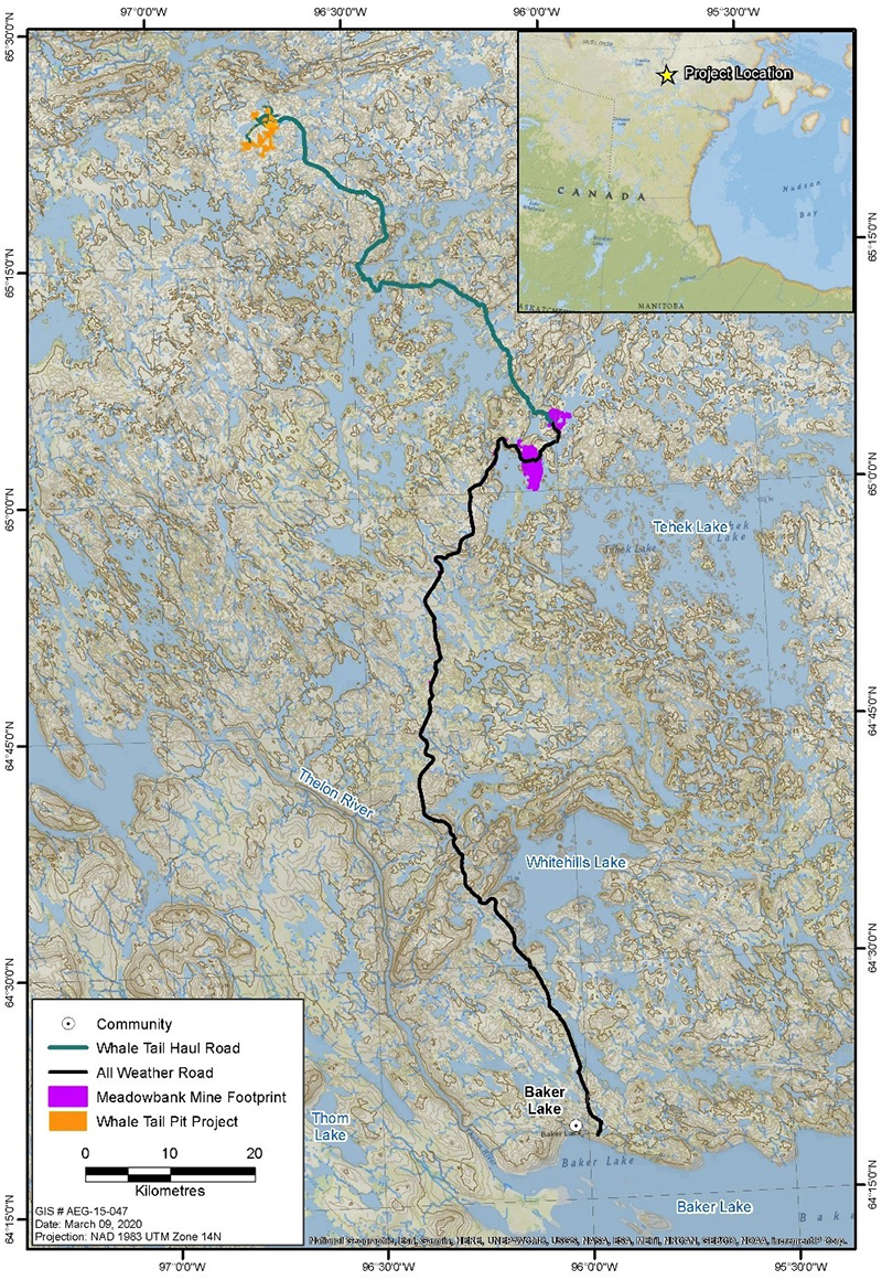
Image description
The top-right corner of the figure shows a 1:25,000,000 scale map of the Nunavut territory at the top, the Northwest Territories to the left, the Hudson Bay to the right and the province of Manitoba at the bottom. It also identifies the location of the project site with respect to the Nunavut territory. The enlarged map at a scale of 1:620,000 shows the location of the Whale Tail Pit Expansion Project in Nunavut. It shows the location of the project with respect to the nearest community, Baker Lake, located south of the project location. The figure also shows Tehek Lake, an important geographical reference, located north of Baker Lake, east of the Meadowbank Mine location and southeast of the Whale Tail Pit location.
The Proponent undertook an assessment of options for the storage of waste rock and effluent based on the Guidelines. The Proponent’s technical reportfootnote 7 describes the steps it undertook to assess the options for the management of mine waste generated by the Project, which are summarized in the Instrument Choice section in this document.
Management of mine waste at the Project
The Project will use both open pit and underground mining methods. These operations will produce 122 Mt of mine waste. The Attenuation Pond, the WRSF and the GSP are described below:
- Attenuation Pond: The Project requires an attenuation pond with the capacity to annually store up to 750,000 cubic metres (mfootnote 3) of mine effluent between October and May so that water can be treated and discharged during ice-free conditions between June and September. The total surface area of the Attenuation Pond is 25.7 hectares (ha) and the surface area of fish habitat to be lost is 14.56 ha.
- WRSF: The Project requires an additional WRSF with a storage capacity of 16.4 million mfootnote 3 to hold 27.6 Mt of waste rock, while the remaining 94.4 Mt will be stored in the existing WRSF. The total surface area of the WRSF is 78 ha and the surface area of fish habitat that will be lost is 2.37 ha.
- GSP: The Project requires three GSPs to manage the effluent from the mining site. One GSP will be located over two water bodies frequented by fish. The total surface area of this GSP is 3.7 ha with a storage capacity of 352,900 mfootnote 3. The surface area of fish habitat that will be lost is 0.54 ha.
The disposal of mine waste will impact seven water bodies or portions of water bodies that are frequented by fish, with a loss of fish habitat totalling 17.47 ha.
Environmental assessment (EA) of the Project
The Project was subject to an EA under the terms of the Nunavut Land Claims Agreement (NLCA). Pursuant to article 12 of the NLCA, the Nunavut Impact Review Board (NIRB) is responsible for the assessment of potential impacts of proposed development in the Nunavut Settlement Area. On December 20, 2018, the Proponent submitted its final environmental impact statement (FEIS) addendum to the NIRB.
Under article 12 of the NLCA, the federal Minister of Northern Affairs must review the NIRB’s report and findings. The Project was approved by the Minister of Northern Affairs in January 2020. Following the completion of the NIRB review process, the Project certificate was issued on February 19, 2020, under certain conditions.
Objective
The objective of the Amendments is to authorize the deposit of mine waste into prescribed fish-frequented water bodies. A requirement of this authorization is that the Proponent must offset the loss of fish habitat resulting from the deposit of mine waste by developing and implementing an FHCP.
Description
The Amendments will list seven water bodies within a prescribed geographical area, to Schedule 2 of the MDMER, designating them as TIAs. The water bodies to be designated as TIAs are Lakes A50, A51, A52 and A53, and their associated watercourses, A50-A17, A51-A50 and A53-A52 (see Figure 2). This will result in the loss of 17.47 ha of fish habitat.
Figure 2: Location of water bodies to be listed in Schedule 2 of the MDMER
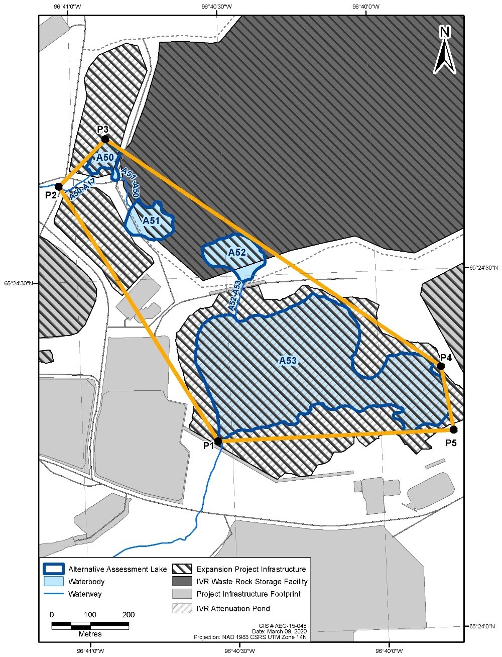
Image description
The area at a scale of 1:7,000 shows the location of the seven water bodies, or portions of water bodies, in Nunavut to be listed in Schedule 2 of the MDMER (i.e. Lakes A50, A51, A52 and A53, and their associated watercourses, A50-A17, A51-A50 and A53-A52). The seven water bodies are grouped together in a geographical area, or polygon. The figure shows the specific points of the polygon of which there are five. The points are labelled P1 through P5 and start at the southernmost point on the southwestern end of Lake A53, moving clockwise. The figure also identifies key mining infrastructure, such as an attenuation pond at the location of Lake A53, a waste rock storage facility directly north of Lake A53.
The DFO determined that the FHCP proposed by the Proponent meets the guiding principles of their Policy for Applying Measures to Offset Adverse Effects on Fish and Fish Habitat Under the Fisheries Act.
Regulatory development
Consultation
The Proponent engaged and consulted the communities in Baker Lake and Chesterfield Inlet between July 2018 and March 2019 on the options for mine waste disposal and the FHCP. The main methods of engagement were open-house and small focus group meetings with elders, women, and youth in addition to meetings with hamlets, the regional Hunters and Trappers Organizations (HTOs), and the KivIA. KivIA is the primary Inuit organization with rights and responsibilities in the Project area. The loss of fish habitat resulting from the Project was explained in detail. No concerns were raised. During the NIRB process, KivIA provided technical comments on the conceptual FHCP, which were addressed by the Proponent.
Modern treaty obligations and Indigenous engagement and consultation
The NLCA is applicable to the Project area and sets out the requirements pertaining to public consultation and engagement and the Crown’s duty to consult with Aboriginal communities as it relates to proposed mineral development projects.
The NIRB is an institution of public government created under the NLCA to assess the potential impacts of proposed development in the Nunavut Settlement Area prior to approval of the required project authorizations. The NIRB requires that mine proponents involved in the NIRB process consult all potentially affected communities and all comments from the public be summarized, documented and presented in an Environmental Impact Statement. Under the provisions of the NLCA, the federal Minister of Northern Affairs must review the NIRB’s report and findings.
The DFO and the Department of the Environment supported the NIRB throughout the review and consultation process of the Project by providing expertise on areas within the mandate of the departments, such as water quality, species at risk, and offsetting. The Department of the Environment engaged the KivIA, regional HTOs and local governments, to consult on the Amendments.
In January 2020, the Department of the Environment informed the Baker Lake HTO, KivIA, the hamlet of Baker Lake and stakeholders that the period for consultation on the Amendments was open until March 2, 2020. No comments were received. In February 2020, officials from the Department of the Environment met with KivIA to discuss the Assessment of Alternatives Report and the FHCP. The KivIA indicated their support for the selection of the mine waste disposal sites.
The Department of the Environment also consulted on plans to apply the policy on Streamlining the Approvals Process for Metal Mines with Tailings Impoundment Areas for the purpose of streamlining, or expediting, the approval timelines for the TIA authorization, and proceeding straight to final publication in Part II of the Canada Gazette. The Amendments were deemed to meet the criteria set out in the policy, which indicates that an exemption from prepublication in the Canada Gazette, Part I, is warranted.
Following this meeting, KivIA sent a letter indicating their support for the Amendments and for the streamlining of the approval process.
Instrument choice
Non-regulatory options would involve the disposal of mine waste in a manner that would not impact fish-frequented water bodies (i.e. land-based options), while regulatory options correspond to those that would impact waters frequented by fish.
The Proponent developed several options in its assessment to determine the best option for mine waste disposal taking into account the environmental, technical, economic and socio-economic factors. This analysis was conducted in accordance with the Guidelines.
Attenuation Pond
The Proponent identified nine potential options meeting their pre-screening criteria to identify viable options for further considerations (see Table 1). The options
- must be located within watersheds already affected by the Existing Project;
- must provide sufficient storage capacity; and
- must align with the approved water management plan for the Existing Project.
| Option |
Description |
Minimum capacity |
|
|---|---|---|---|
A. |
Expand existing Whale Tail Attenuation Pond (relocate Whale Tail Dike) |
The Whale Tail Dike would be moved south, or a second dike constructed, to increase the available area within the North Basin. |
Whale Tail Attenuation Pond would be expanded from 133,000 m3 to at least 750,000 m3. |
B. |
Expand existing Whale Tail Attenuation Pond (northern containment feature) |
Containment feature would be constructed along the north side of the Whale Tail Attenuation Pond, which would be enlarged within the drained North Basin of Whale Tail Lake (non-regulatory option). |
Whale Tail Attenuation Pond would be expanded from 133,000 m3 to at least 750,000 m3. |
C. |
Expand existing Whale Tail WRSF Pond |
The WRSF Dike would be elevated to increase the capacity of the Whale Tail WRSF Pond and provide storage within the footprint of a flooded WRSF (non-regulatory option). |
Whale Tail Attenuation Pond would provide capacity for 133,000 m3. Whale Tail WRSF Pond will be expanded from 11,600 m3 to at least 617,000 m3. |
D. |
Expand existing Whale Tail WRSF Pond and existing Whale Tail Attenuation Pond |
The Whale Tail WRSF Dike would be elevated to increase the capacity of the Whale Tail WRSF Pond; however, the pond would not be increased to a level where waste rock would be in contact with the pond. In addition, a containment feature would be constructed along the north side of the Whale Tail Attenuation Pond, which would be enlarged within the drained North Basin of Whale Tail Lake (non-regulatory option). |
The combined capacity of Whale Tail Attenuation Pond and Whale Tail WRSF Pond would be expanded from 144,600 m3 to at least 750,000 m3. |
E. |
New attenuation pond at Lake A53 (preferred option) |
Containment feature(s) would be constructed at Lake A53 to enlarge the existing water body. |
Whale Tail Attenuation Pond would provide capacity for 133,000 m3. Lake A53 will be expanded to at least 617,000 m3. |
F. |
New attenuation pond at Lake A54 |
Containment feature(s) would be constructed at Lake A54 to enlarge the existing water body (non-regulatory option). |
Whale Tail Attenuation Pond would provide capacity for 133,000 m3. Lake A54 will be expanded to at least 617,000 m3. |
G. |
New attenuation pond at Mammoth Lake |
A dam would be constructed to isolate the northern section of Mammoth Lake. |
Whale Tail Attenuation Pond would provide capacity for 133,000 m3. The north portion of Mammoth Lake would be isolated to provide capacity for at least 617,000 m3. |
H. |
New attenuation pond at Lake A53 and expand existing Whale Tail Attenuation Pond |
Containment feature(s) would be constructed at Lake A53 to enlarge the existing water body. In addition, a containment feature would be constructed along the north side of the Whale Tail Attenuation Pond, which would be enlarged within the drained North Basin of Whale Tail Lake. |
The combined capacity of Whale Tail Attenuation Pond and Lake A53 would be expanded to at least 750,000 m3. |
I. |
Sequential mining and/or quarry development |
Sequential mining and/or quarry development in order to use pits and quarries as temporary attenuation ponds. For example, water would be stored in the Whale Tail Pit while ore is extracted from the IVR Pit, and then pumped to the IVR Pit while the Whale Tail Pit is enlarged (non-regulatory option). |
The combined capacity of the Whale Tail Attenuation Pond and sequential use of pits and quarries would provide capacity for at least 750,000 m3. |
Following the pre-screening process, the proponent’s assessment screened the options to eliminate those that would present material engineering and safety risks; fail to avoid areas of high environmental, cultural and/or archeological value; sterilize mineral resources; or contradict the approved mine plan. As a result of this analysis, options A, C, D and I were eliminated and options B, E, F, G, and H (including two non-regulatory options that would not result in the loss of fish-frequented water bodies) were carried through for further analysis.
Considering technical, environmental, human, and economic factors, option E is the preferred option because of its relatively small footprint, reduced need for surface water management infrastructure, reduced complexity over the life of the pond, and reduced consequences in the event of dam failure or overtopping.
Waste Rock Storage Facility
The Proponent identified 13 potential options meeting the pre-screening criteria developed by the Proponent to identify viable options for further considerations (see Table 2). The options
- must provide sufficient storage capacity to store up to approximately 109.1 Mt of waste rock; and
- must minimize potential environmental impacts to areas otherwise undisturbed by physical infrastructure.
| Option |
Description |
|---|---|
A |
Would overprint four water bodies (A50, A51, A52, and A-P21) and would be located in multiple sub-watersheds. |
B |
Situated northwest of Option A to avoid overprinting water bodies A50, A51, A52, and A-P21. Would overprint two small unnamed water bodies in the northwest corner of the facility and would be located in multiple sub-watersheds. |
C |
Situated just north of water bodies A113 and A0 and would be partially located in the Nemo Lake watershed. Would overprint two unnamed water bodies. |
D |
Situated north of the approved Whale Tail WRSF footprint within a single sub-watershed. Would overprint three small water bodies. |
E |
Situated within the Mammoth Lake sub-watershed and to the west of the approved Whale Tail WRSF footprint. Would not overprint water bodies. |
F |
Situated primarily within the Mammoth Lake sub-watershed and to the south of Mammoth Lake. To provide sufficient capacity, it is likely that the storage facility would also extend towards the sub-watersheds to the south of Mammoth Lake. Would not overprint water bodies. |
G |
Situated primarily within the Mammoth Lake sub-watershed and to the southwest of Mammoth Lake. To provide sufficient capacity, it is likely that the facility would also extend towards the sub-watersheds to the south. Would not overprint water bodies. |
H |
Situated the furthest from the Whale Tail Project infrastructure and located at the southwest corner of Mammoth Lake. The WRSF would be located within multiple sub-watersheds and overprints one small water body. |
I |
Situated southeast of the Whale Tail Project Infrastructure, adjacent to the access road. The footprint of the WRSF would overprint a large water body (A56) and would be in a single sub-watershed. |
J |
Situated to the east of Lake A53 and the ore stockpile. The WRSF would overprint water body A54 and would be situated within three sub-watersheds. |
K |
Situated southwest of Option A to avoid overprinting water bodies A50, A51, A52. Overprints water body A-P21 (not fish-frequented) and would be located in multiple sub-watersheds. |
L |
Involves expansion of the Whale Tail WRSF without the development of a second WRSF. This option would include expanding the Whale Tail WRSF both east and west of the approved WRSF footprint. Would not overprint water bodies and be located within the Mammoth Lake sub-watershed. |
M |
Involves storage of waste rock from the additional pit in the exhausted Whale Tail open pit. This option would require sequential (rather than concurrent) mining of pits. |
Following the pre-screening assessment, options A, B and K (including one non-regulatory option that would not impact fish-frequented water bodies) were included for further assessment.
The preferred option (Option A) facilitates effective management of surface water quality impacts as natural drainage conditions support the collection of contact water from the WRSF to the attenuation pond. The preferred location of the WRSF would result in the loss of three water bodies (two lakes and one watercourse) that are fish-frequented. The total surface area of fish habitat that would be lost by the development of WRSF is 2.37 ha.
The preferred option for the WRSF requires infrastructure to collect mine effluent. A new GSP proposed to be located adjacent to the new WRSF for the collection of mine effluent would impact a water body and a watercourse that are fish-frequented. The area of fish habitat that would be lost by the GSP is 0.54 ha.
Regulatory analysis
Benefits and costs
Analytical framework
The Amendments will list seven water bodies frequented by fish within a prescribed geographical area to Schedule 2 of the MDMER, thereby authorizing the Proponent to use them for the disposal of mine waste. The Proponent developed an FHCP that includes offsetting measures such as
- restoring degraded fish habitat to improve conditions for the production of fish;
- enhancing fish habitat to improve conditions for the production of fish; and
- creating productive and sustainable fish habitat where none existed before.
The analysis below examines the incremental impacts of the Amendments on the environment, businesses (the Proponent), and the Government. While costs for the Proponent are known and monetized, it is not feasible to quantify and monetize benefits due to data limitations. As a result, the cost-benefit analysis reflects monetized costs and qualitatively described impacts. The cost and environmental impacts of the Amendments could change if the scope of the FHCP was to be subsequently amended.
Environmental impacts
The disposal of mine waste will result in the loss of seven water bodies or portions of water bodies that are frequented by fish and totalling 17.47 ha of fish habitat.
The conversion of Lake A53 to an attenuation pond will result in its complete loss as fish habitat. Fish species supported by Lake A53 include lake trout, arctic char, burbot, slimy sculpin, and ninespine stickleback. Lake A53 and its ephemeral watercourse A52-A53 will result in a total loss of 14.56 ha in fish habitat.
Lakes A50, A51 and A52 will be impacted as a result of the WRSF and the GSP associated with the Project. A fisheries assessment identified ninespine stickleback to inhabit lakes A50, A51, and A52. Lake A52 drains to Lake A53 via a shallow multi-thread watercourse during spring freshets. As the season progresses the watercourse first goes dry with Lake A52 going dry later in the summer. The lakes and their ephemeral watercourses (A50-A17 and A51-A50) will equal a loss in 2.91 ha of fish habitat.
The loss of fish habitat will be offset by the implementation of the FHCP, as required under section 27.1 of the MDMER. The implementation of the compensatory measures will result in the creation of 20.9 ha of fish habitat of equivalent or superior quality compared to the fish habitat to be lost by the disposal of mine waste. The Proponent will construct a permanent sill upstream of Lake A18 (Figure 3) that will sustain water levels above those currently authorized under the Existing Project. As a result, the sill will render temporary fish habitat in Lake A18 permanent. The habitat types for the area that will be affected by the sill between Lake A18 and Whale Tail Lake are shown in Figure 3 and described in Table 3.
Figure 3: The Project Plan to Offset the Loss of Fish Habitat
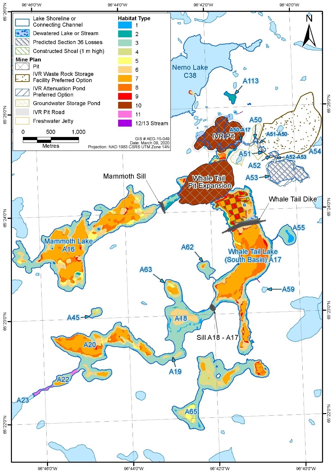
Image description
The map area at a scale of 1:35,000 shows the project site and the location of the sill in Nunavut to be constructed as part of the compensation plan to offset the loss of fish habitat. It shows the location of the sill with respect to the nearest water bodies: Whale Tail Lake located directly north of the sill, Nemo Lake located to the north of Whale Tail Lake, and Mammoth Lake located to the northwest of the sill.
| Habitat type |
Feature: depth |
Substrate |
|---|---|---|
1 |
Lake: 0-2 m |
Fine |
2 |
Lake: 0-2 m |
Mixed |
3 |
Lake: 0-2 m |
Coarse |
4 |
Lake: 2-4 m |
Fine |
5 |
Lake: 2-4 m |
Mixed |
6 |
Lake: 2-4 m |
Coarse |
7 |
Lake: >4 m |
Fine |
8 |
Lake: >4 m |
Mixed |
9 |
Lake: >4 m |
Coarse |
10 |
pit and pit cap table b2 note * |
Pit and pit cap table b2 note * |
11 |
connecting channels |
Coarse |
12 |
small streams |
Fine |
13 |
small streams |
Coarse |
Table b2 note(s)
|
||
Cost to business
The implementation of the FHCP associated with the Amendments in order to compensate for the loss of 17.47 ha of fish habitat is estimated to cost $1.34 millionfootnote 8 for Agnico Eagle Mines Limited. Table 4 describes the estimated costs associated with the implementation of the FHCP. A18 Sill will be constructed in 2026 at closure of the Project and post-construction monitoring for the Sill is expected to occur between 2027 and 2029.
| Description |
Undiscounted amount in 2020 Canadian dollars |
Amount discounted at a rate table b3 note * of 3% |
Proposed schedule |
|---|---|---|---|
Construction |
$1,230,048 |
$1,030,146 |
2026 |
Monitoring plan |
$108,623 |
$85,773 |
2027-2029 |
Total |
$1,338,671 |
$1,115,919 |
|
Table b3 note(s)
|
|||
Cost to government
Government of Canada enforcement activities include inspections to monitor the implementation of the FHCP, which may have associated incremental costs. Specifically, there may be site visits, monitoring and review costs incurred by the DFO. These incremental costs will be low, given that monitoring activities and associated costs will only occur intermittently during the implementation of the FHCP and will not continue throughout the life of the mine waste disposal areas.
Incremental compliance promotion costs, if incurred, will also be low given that compliance promotion activities occurred throughout the federal environmental assessment process.
Therefore, the total incremental costs to the Government associated with the proposed FHCP will be low.
| Total (present value) |
Annualized average (10 years) |
||
|---|---|---|---|
A. Quantified impacts (2020 price level in constant dollars [$ million]) |
|||
Costs |
By Agnico Eagle Mines Limited |
1.12 |
0.13 |
Net benefits |
|||
B. Quantified impacts in non-$ (e.g. from a risk assessment) |
|||
Positive impacts |
Indigenous peoples, the general public |
The loss of fish habitat associated with the disposal of mine waste rock and effluent will be offset by the implementation of a compensation plan and will result in a direct gain of 20.9 ha of fish habitat. |
|
Negative impacts |
Indigenous peoples, the general public |
The loss of fish habitat associated with the disposal of mine waste rock and effluent amounts to 17.47 ha. |
|
Small business lens
There are no impacts on small business associated with the Amendments. Agnico Eagle Mines Limited, the owner and operator of the mine, does not meet the definition of small business as set out in the Policy on Limiting Regulatory Burden on Business.
One-for-one rule
The one-for-one rule does not apply as there is no incremental change in administrative burden on business.
Regulatory cooperation and alignment
The Amendments do not have a regulatory cooperation component.
Strategic environmental assessment
A strategic environmental assessment for the MDMER concluded that authorizing the disposal of tailings in a TIA will have adverse environmental effects, namely, the loss of fish habitat. However, the adverse environmental effects will be offset by the implementation of an FHCP that will result in no net loss of fish habitat. The Proponent must also submit an irrevocable letter of credit covering the implementation costs of the plan, including the costs of any corrective measures necessary if the objective of the plan is not achieved.
Gender-based analysis plus
Provided the FHCP is implemented, the Department of the Environment has determined that the amendments are not expected to disproportionately affect Indigenous peoples or any other socio-demographic group. No gender-based analysis plus (GBA+) impacts have been identified.
Implementation, compliance and enforcement, and service standards
The Amendments will authorize Agnico Eagle Mines Limited to use certain water bodies that are fish-frequented for disposal of waste rock and effluent generated from the activities of the Whale Tail Pit Expansion Project.
Given that the MDMER are made pursuant to the Fisheries Act, enforcement personnel would, when verifying compliance with the MDMER, act in accordance with the Compliance and enforcement policy for habitat and pollution provisions of Fisheries Act. Verification of compliance with the MDMER and the Fisheries Act would include, among other inspection activities, site visits, sample analysis, review of FHCPs and related reports associated with the Amendments.
If there is evidence of an alleged offence of the fisheries protection and pollution prevention provisions of the Fisheries Act and/or related regulations, enforcement personnel would determine an appropriate enforcement action, in accordance with the following criteria, as set out in the Compliance and enforcement policy for habitat and pollution provisions of Fisheries Act:
- the nature of the alleged violation;
- effectiveness in achieving the desired result with the alleged violator; and
- consistency in enforcement.
Given the circumstances and subject to the exercise of enforcement and prosecutorial discretion, the following instruments are available to respond to alleged violations:
- directions;
- orders by the Minister;
- injunctions; and
- prosecutions.
Contacts
Aimee Zweig
Executive Director
Mining and Processing Division
Industrial Sectors and Chemicals Directorate
Environment and Climate Change Canada
351 Saint-Joseph Boulevard
Gatineau, Quebec
K1A 0H3
Email: ec.mmer-remm.ec@canada.ca
Matthew Watkinson
Director
Regulatory Analysis and Valuation Division
Economic Analysis Directorate
Environment and Climate Change Canada
200 Sacré-Cœur Boulevard
Gatineau, Quebec
J8X 4C6
Email: ec.darv-ravd.ec@canada.ca