Canada Gazette, Part I, Volume 156, Number 34: Supplement
August 20, 2022
FEDERAL ELECTORAL BOUNDARIES COMMISSION FOR THE PROVINCE OF QUEBEC
Proposal of the Federal Electoral Boundaries Commission for the Province of Quebec
Part I – Introduction
The Federal Electoral Boundaries Commission for Quebec (the Commission) was established by proclamation, dated November 1, 2021, and published in the Canada Gazette on November 24, 2021, in accordance with the provisions of the Electoral Boundaries Readjustment Act, R.S.C. 1985, Chapter E-3 (the Act). The Commission consists of the Chair, the Honourable Jacques Chamberland, retired Quebec Court of Appeal Justice, and members André Blais, Full Professor, Department of Political Science, Université de Montréal, and Louis Massicotte, retired Full Professor, Department of Political Science, Université Laval. The Chair was appointed by the Chief Justice of Quebec, the Honourable Manon Savard, while the other two members were appointed by the Speaker of the House of Commons.
Voting is the very foundation of any democracy.
In Canada, the right to vote is constitutionally protected by its inclusion in section 3 of the Constitution Act, 1982, Part 1 - Canadian Charter of Rights and Freedoms (the Charter): “Every citizen of Canada has the right to vote in an election of members of the House of Commons or of a legislative assembly and to be qualified for membership therein.”
The entire territory of Canada is divided into a number of electoral districts to ensure that the will of Canadian citizens who vote is adequately represented. The way a territory is divided into electoral districts is not frozen in time; it evolves with population movements. Updating the electoral map involves a large-scale readjustment of the boundaries every 10 years, based on the data from the last decennial census. As a result, throughout Canada, commissions independent of political power have been established, whose mission is to divide the territory of the province for which each commission has been constituted into electoral districts, to establish their respective boundaries and populations and, finally, to give them a name.
One of the reasons for the independence of these commissions is to counteract one of the shortcomings of some democracies, namely, the practice of manipulating electoral boundaries for partisan purposes.
Commissions do not have the mandate to change the number of electoral districts calculated by the Chief Electoral Officer of Canada for each province.
The revision of the electoral map is tightly controlled by the Act. It involves a series of steps, the first of which is to develop a proposal “with all reasonable dispatch” (subsection 14(2)) after the Chief Electoral Officer publishes the calculation of the number of parliamentary seats in each province. This step has now been completed.
The second step will be for the Commission to consult with the people of Quebec by sitting in several locations across the province and, in order to allow as many people as possible to express their views, by holding some virtual sessions (see Part VI of the proposal). This is an essential step in the electoral map revision process. The Commission intends to devote about 20 days to this, as did the previous commission.
The third step will be for the Commission to incorporate the results of this consultation into its considerations and to prepare a report for presentation to the House of Commons.
The fourth and final step in the Commission’s work will be to resolve any objections raised by members of Parliament (MPs) and, if necessary, amend its report before returning a certified copy to the Speaker of the House of Commons within 30 days.
At the end of the exercise, the Commission will have carried out three successive boundary redrawing projects: a proposal, intended to be the subject of consultations with the population of Quebec; a report, prepared in the wake of the public consultations and intended to be the subject of a final consultation with members of the House of Commons; and lastly, a final report that will take MPs’ objections into account, if applicable.
The Commission’s work is subject to compliance with the Official Languages Act.
Part II – Principles
The redistribution of electoral districts is subject to the principles set out in section 15 of the Act:
15 (1) In preparing its report, each commission for a province shall, subject to subsection (2), be governed by the following rules:
- (a) the division of the province into electoral districts and the description of the boundaries thereof shall proceed on the basis that the population of each electoral district in the province as a result thereof shall, as close as reasonably possible, correspond to the electoral quota for the province, that is to say, the quotient obtained by dividing the population of the province as ascertained by the census by the number of members of the House of Commons to be assigned to the province as calculated by the Chief Electoral Officer under subsection 14(1); and
- (b) the commission shall consider the following in determining reasonable electoral district boundaries:
(i) the community of interest or community of identity in or the historical pattern of an electoral district in the province, and
(ii) a manageable geographic size for districts in sparsely populated, rural or northern regions of the province.
(2) The commission may depart from the application of the rule set out in paragraph (1)(a) in any case where the commission considers it necessary or desirable to depart therefrom
- (a) in order to respect the community of interest or community of identity in or the historical pattern of an electoral district in the province, or
- (b) in order to maintain a manageable geographic size for districts in sparsely populated, rural or northern regions of the province,
but, in departing from the application of the rule set out in paragraph (1)(a), the commission shall make every effort to ensure that, except in circumstances viewed by the commission as being extraordinary, the population of each electoral district in the province remains within twenty-five percent more or twenty-five percent less of the electoral quota for the province.
The population figure for each electoral district should correspond “as close as reasonably possible” to the quotient resulting from dividing the population figure for the province by the number of MP seats to be filled (“the electoral quota”). This principle of parity may be waived where it is considered “necessary or desirable,” in which case the Commission must ensure that, except in “circumstances viewed by the commission as being extraordinary,” the population of the electoral district must remain within 25% above or below the electoral quota.
With respect to electoral district boundaries, in addition to the electoral quota, consideration should be given to the community of interest or specificity of the district or its historical development. Lastly, care should be taken to ensure that the size of districts in sparsely populated, rural or northern areas is “manageable.”
These principles have been carefully considered by the Supreme Court of Canada in Reference re Prov. Electoral Boundaries (Sask.), (SCC), [1991] 2 SCR 158 and, more recently, Toronto (City) v. Ontario (Attorney General), 2021 SCC 34.
The highest court in the country has instructed that the exercise of the power to set electoral boundaries is subject to section 3 of the Charter, which guarantees every Canadian citizen the right to vote. On the crucial question of whether deviation from the “one person, one vote” rule is permissible in redistributing electoral districts, the Supreme Court responded that the issue is not so much one of achieving absolute equality of citizens or voters, but rather the broader issue of ensuring effective representation; that is, the right of all citizens to be represented in Parliament and to have access to an MP as well as to their assistance.
Voting power parity is the most important factor in ensuring effective voter representation. Unduly diluting the vote of one citizen with that of another may result in inadequate representation of that citizen. This would reduce this person’s legislative power, as well as the citizen’s access to and assistance from their MP. However, voting power parity is not the only factor that must be considered to ensure that different interests, groups and communities are fairly represented in the House of Commons. Other factors, including those mentioned in section 15 of the Act and Supreme Court decisions (the geographic characteristics of an electoral district, its historical boundaries, the interests of a particular community or its history, the representation of minority groups), may justify the Commission’s departure from the “one person, one vote” rule in the interest of, in the words of the Supreme Court, effective representation of “the diversity of our social mosaic.”
These principles were at the heart of the Commission’s considerations.
Part III – Rationales and Reasons
The Commission’s mandate is twofold: to determine the boundaries and populations of electoral districts, and then to decide on the name to be assigned to each electoral district.
Boundaries and populations
On October 15, 2021, the Chief Electoral Officer announced the results of his calculation of the number of members’ seats to be allocated to each province, based on (a) the estimates of the population of Canada and of each province received from the Chief Statistician of Canada, and (b) the rules relevant to that calculation contained in the Constitution Act, 1867, as amended by the Fair Representation Act, S.C. 2011, c. 26 (results published in the Canada Gazette, Part I, on October 16, 2021, p. 5145).
In the case of Quebec, the electoral map was to be revised within 77 electoral districts.
Since that time, Parliament has intervened through legislation to ensure that “the province [will have] the same number of members as were assigned during [the forty-third] Parliament” (Preserving Provincial Representation in the House of Commons Act, S.C. 2022, c. 6, assented to on June 23, 2022), section 2 (the 2022 Act).
Under the transitional provisions of the 2022 Act, the Chief Electoral Officer has recalculated the number of MP seats to be allocated to each province and has had the results of this calculation published in the Canada Gazette. The number of MP seats allocated to Quebec is now 78, and the electoral quota is 108,998 persons per electoral district. Since the population of the electoral district must remain within 25% above or below the electoral quota, no electoral district should have fewer than 81,749 people (-25%) or more than 136,247 people (+25%).
This variance concept deserves to be explained, as it is fundamental to the scheme of the Act and guided the Commission in its approach. The electoral quota is the average population of an electoral district. It is calculated by dividing the total population of the province by the number of seats allocated to it. Naturally, the population of each electoral district will differ from this quotient. This difference, called variance, is commonly expressed as a positive or negative percentage of the quota. If there is a positive variance, residents will be said to be underrepresented, and the power of individual residents will be weakened. Conversely, if the difference is negative, it will be said that there is overrepresentation and that the power of each resident is excessive.
Before going any further, it is interesting to compare the situation as it was when the previous commission completed its work and what it is today, 10 years later. To do this, the Commission will use a table of percentage variances between the population of the electoral districts and the applicable electoral quota in 2011 and 2021, respectively.
The boundaries of the 78 electoral districts established on the basis of the 2011 census have not been changed since then, although the names of several electoral districts have been changed by Parliament. Meanwhile, the population of Quebec has grown from 7,903,001 to 8,501,833, an increase of 7.6% in 10 years.
However, this growth is far from consistent throughout the province. In 22 electoral districts, the population increased by 10% or more. In one of them (Ville-Marie—Le Sud-Ouest—Île-des-Sœurs), the rate of increase even reached 30.5%. On the other hand, six electoral districts experienced a decrease in absolute figures, and one of them (Manicouagan) had a 6.6% decrease in population.
A redistribution on this scale would significantly alter the demographic balance that the current boundaries are based on. The electoral boundaries have not changed, but the population has shifted significantly.
This has resulted in a significant increase in the electoral quota variances between 2011 and 2021.
The table below covers the current 78 electoral districts. It shows the frequency distribution of variances based on 2011 and 2021 population figures.
| Size of variance | 2011 | 2021 |
|---|---|---|
| Greater than -25% | 1 | 3 |
| -25% to -15% | 4 | 5 |
| -15% to -10% | 2 | 3 |
| -10% to -2% | 17 | 19 |
| -2% to 2% | 16 | 14 |
| 2% to 10% | 36 | 22 |
| 10% to 15% | 2 | 7 |
| 15% to 25% | 0 | 5 |
| Greater than 25% | 0 | 0 |
| Total number of electoral districts | 78 | 78 |
This comparison between the two columns of the table clearly illustrates the relevance of updating the electoral map.
In 2011, only one electoral district exceeded the maximum 25% variance. Today, there are three. In the same period, the number of districts that varied from the average by 10% or more increased from 9 to 22. The least populated district went from 74,547 to 70,253, and the most populated district went from 112,385 to 134,555 (not the same district).
It is also worth noting that the distortion index that is most commonly used internationally to measure inequality in a territorial division, the Loosemore-Hanby index, has increased in 10 years from 0.0292 to 0.0415 today.footnote 1 Simply put, the political weight of the vote of electors in different districts is even more unequal today than it was 10 years ago, and only a revision of the electoral map will correct these inequalities.
The division of the province into electoral districts is a complex and delicate exercise. There are few principles underlying this exercise, but their application is fraught with difficulties, as evidenced by the reports of previous commissions and the Supreme Court decisions mentioned above.
At the outset of its work, the Commission chose to invite comments and suggestions from the public even before this proposal was tabled. This additional consultation to that provided for in the Act seemed to be the right thing to do in the context of an exercise (redrawing the electoral map) intended to be the outcome of a dialogue between the Commission and the public.
The Commission would like to take this opportunity to thank those who have already submitted their suggestions and comments. They have enriched the Commission’s reflections in developing this proposal. The Commission would also like to thank in advance those who will be providing feedback on its proposal. They will help make the report to the House of Commons better.
The Commission, like the two commissions that preceded it, considers it appropriate that, save for justified exceptions, the population of each of Quebec’s electoral districts be within a maximum positive or negative variance of 10% in relation to the electoral quota. This target variance seems appropriate given the importance of the principle of parity (“one person, one vote”), the objective being to give a more or less equivalent weight to the population of each electoral district. This search for demographic balance within all electoral districts is in keeping with what previous commissions have done. That being said, this does not involve perverting the search for this ideal parity into a purely mathematical exercise.
The Act requires commissions to set out the reasons for their recommendations regarding the division of their corresponding province’s electoral districts. Here they are.
After reviewing the 78 existing electoral districts, the Commission proposes leaving the following 16 electoral districts (current names) intact:
- Abitibi—Baie-James—Nunavik—Eeyou
- Abitibi—Témiscamingue
- Beauce
- Bourassa
- Brome—Missisquoi
- Brossard—Saint-Lambert
- La Pointe-de-l’Île
- La Prairie
- Lac-Saint-Louis
- Longueuil—Charles-LeMoyne
- Manicouagan
- Papineau
- Pierrefonds—Dollard
- Rosemont—La Petite-Patrie
- Saint-Jean
- Saint-Maurice—Champlain
- Trois-Rivières
The Commission is also proposing removing a seat in Gaspésie and creating a new district north of Montréal in the Laurentians.
Finally, the Commission is proposing changes to the boundaries of 60 other electoral districts, to varying degrees, in order to bring their population closer to the new electoral quota and, in some cases, to correct errors in their technical description.
Quebec is divided into administrative regions. For the sole purpose of clarifying the presentation of the proposed amendments, they are grouped into territorial units that correspond approximately to a region, a subdivision of a region or a grouping of several contiguous regions.
Abitibi-Témiscamingue and Nord-du-Québec
This group includes two districts with a total of 192,822 people. The area is immense, covering more than half of Quebec’s total area. The average population of the entire area (96,411) is 11.5% lower than the Quebec average.
The Commission is not proposing any changes to these districts. None of them have seen their population decline in the last 10 years. The size of Abitibi—Baie-James—Nunavik—Eeyou (858,585 km) more than justifies that its otherwise dispersed population (89,087) deviate from the electoral quota by -18%.
Saguenay-Lac-Saint-Jean and Côte-Nord
| Electoral District | 2011 Population | 2021 Population |
|---|---|---|
| Chicoutimi—Le Fjord | 81,501 | 80,593 |
| Jonquière | 87,596 | 91,073 |
| Lac-Saint-Jean | 105,783 | 103,886 |
| Manicouagan | 94,766 | 88,525 |
| Total | 369,646 | 364,077 |
| Average | 92,412 | 91,019 |
In the course of its work, the Commission considered the possibility of removing one of the three MP seats from Saguenay-Lac-Saint-Jean, which would have resulted in a significant expansion of the neighbouring district of Manicouagan and a marked reduction in the average variance in the three remaining districts of the territorial unit. However, the two electoral districts of the Saguenay-Lac-Saint-Jean region would have had the highest populations in Quebec without any realistic possibility of transferring the surplus population to neighbouring electoral districts. That option was therefore ruled out.
While maintaining the number of seats in Saguenay-Lac-Saint-Jean, the Commission deems it necessary to reduce the disparities between the region’s three electoral districts, whose population currently varies from 80,593 to 103,886. It is ironic, to say the least, that the most populated district is the one with the most dispersed population, while the two more urbanized districts have fewer residents. The Commission proposes bringing these closer to the provincial average and reconfiguring the Lac-Saint-Jean electoral district, while ensuring that it continues to include all the municipalities bordering the lake. The population of the three proposed districts will range from 91,061 to 92,460.
Manicouagan will remain unchanged with 88,525 residents. The deficit compared to the average is 19%, the highest in all of Quebec, which, in the Commission’s opinion, is justified by the vastness of the district, with a total area of 313,029 km.
Montmagny to Îles-de-la-Madeleine
This group includes the eastern part of the Chaudière-Appalaches region, as well as the entire administrative regions of Bas-Saint-Laurent and Gaspésie-Îles-de-la-Madeleine. There are currently four electoral districts: Montmagny—L’Islet-Kamouraska—Rivière-du-Loup, Rimouski-Neigette—Témiscouata—Les Basques, Avignon—La Mitis—Matane—Matapédia and Gaspésie—Les Îles-de-la-Madeleine, with a total population of 328,460.
| Electoral Districts | 2011 Population | 2021 Population |
|---|---|---|
| Montmagny—L’Islet—Kamouraska—Rivière-du-Loup | 97,261 | 96,724 |
| Rimouski-Neigette—Témiscouata—Les Basques | 84,809 | 85,556 |
| Avignon—La Mitis—Matane—Matapédia | 74,547 | 70,253 |
| Gaspésie—Les Îles-de-la-Madeleine | 78,833 | 75,927 |
| Total | 335,450 | 328,460 |
| Average | 83,863 | 82,115 |
The average population of the entire area is 82,115, the lowest of all the regions in Quebec, and very close to the -25% limit imposed by the Act. Each of the electoral districts has a significant deficit: the variance is -21.5% for Rimouski-Neigette—Témiscouata—Les Basques, and reaches -30.3% and -35.5% for Gaspésie—Les Îles-de-la-Madeleine and Avignon—La Mitis—Matane—Matapédia, respectively. In 2012, the commission at the time agreed that the exception in extraordinary circumstances should be allowed for Avignon—La Mitis—Matane—Matapédia, which at the time showed a 26% deficit. Today, two districts exceed the 25% limit, and three of the four least populated districts in Quebec are located in this region.
This situation is part of a decline that began several decades ago. In 35 years, Bas-Saint-Laurent has lost 7.5% of its population, and Gaspésie has lost 19.8%.footnote 2 Since 2011, three of the four districts have seen their populations decrease in absolute figures, and the population of the fourth has only increased by 747 people. All these districts experienced a relative decrease, while the population of Quebec increased by 7.6% during the same period.
In order to respect the principle of relative vote parity, the Commission proposes reducing the number of MP seats for the region from four to three. Removing Avignon—La Mitis—Matane—Matapédia is the best option because, on the one hand, it is the least populated of the four electoral districts, and the least populated of all the electoral districts in Quebec, and, on the other hand, its geographic location allows the two neighbouring electoral districts to absorb its components.
The Commission proposes that the municipalities located, in whole or in part, east of a line formed by Route 132 and Route 195, excluding Matane, be transferred to Gaspésie—Les Îles-de-la-Madeleine. The population of the Gaspésie—Les-Îles-de-la-Madeleine electoral district will consequently increase from 75,927 to 104,682 (-4% variance).
The Commission proposes that all the other municipalities currently included in Avignon—La Mitis—Matane—Matapédia be transferred to the neighbouring electoral district of Rimouski-Neigette—Témiscouata—Les Basques. In turn, the Regional County Municipality (RCM) of Témiscouata will be detached from this district and attached to Montmagny—L’Islet—Kamouraska—Rivière-du-Loup. The Commission believes that the excellent communication routes linking Montmagny to Rivière-du-Loup and Rivière-du-Loup to New Brunswick, through Témiscouata, justify this transfer, even if it results in a population surplus for this electoral district.
The population of Montmagny—L’Islet—Kamouraska—Rivière-du-Loup will increase to 116,216 (+7% variance), and the population of Rimouski-Neigette—Témiscouata—Les Basques, to 107,562 (-1%).
City of Québec and surrounding area
This portion of the north shore of the St. Lawrence River runs from Portneuf—Jacques-Cartier to Beauport—Côte-de-Beaupré—Île d’Orléans—Charlevoix and has the City of Québec as its centre. In 10 years, its population growth rate has been slightly higher than the Quebec average. In addition, the strong demographic growth recorded in the northwestern suburbs of the City of Québec has generated significant variances (about 13% in Louis-Saint-Laurent and Portneuf—Jacques-Cartier) that require adjustments.
The Commission is proposing expanding the electoral district of Québec, which is currently under 100,000 people, by adding two adjacent sectors from the electoral districts of Louis-Hébert to the southwest and Beauport—Limoilou to the east. It also proposes reuniting the entire borough of Beauport, which currently straddles two electoral districts bearing that name, by moving the eastern boundary of Beauport—Limoilou to the Montmorency River. Finally, the Commission proposes that the Huron-Wendat reserve of Wendake be transferred from the electoral district of Louis-Saint-Laurent to Charlesbourg—Haute-Saint-Charles in order to balance the population figures of these two neighbouring electoral districts and to bring them closer to the provincial average. The total population of the region’s electoral districts will range from 106,117 to 110,320, compared to the current range of 95,736 to 123,243.
Chaudière-Appalaches (western part), Estrie and Centre-du-Québec
On the south shore of the St. Lawrence River, the two electoral districts that each include part of the City of Lévis contain significant population surpluses (+10.3% for Bellechasse—Les Etchemins—Lévis and +8.8% for Lévis—Lotbinière). The Commission proposes limited transfers to bring their respective populations closer to the provincial average. The municipality of Saint-Henri will be transferred from Bellechasse—Les Etchemins—Lévis to Lévis—Lotbinière, while Lévis—Lotbinière will transfer some municipalities to Mégantic—L’Érable.
The electoral districts of Mégantic—L’Érable (-18.4%) and Bécancour—Nicolet—Saurel (11.5%) stand out because of their significant population deficits. Transferring part of the Lévis—Lotbinière electoral district to Mégantic—L’Érable will increase the population of Mégantic—L’Érable from 88,894 to 105,458. The transferred municipalities are Dosquet, Saint-Agapit, Saint-Gilles, Saint-Narcisse-de-Beaurivage, Saint-Patrice-de-Beaurivage, Saint-Sylvestre and Sainte-Agathe-de-Lotbinière. The population deficit in Bécancour—Nicolet—Saurel will be offset by adding a few municipalities from the Drummond district: Saint-Eugène, Saint-Guillaume, Saint-Pie-de-Guire and Sainte-Brigitte-des-Saults.
Still with the objective of reducing variances, the Commission also proposes transferring a portion of the southern part of the Sherbrooke district to Compton—Stanstead. For the same purpose, four municipalities located in the eastern part of Shefford will be transferred to Saint-Hyacinthe—Bagot (the municipality of Maricourt, the village and township of Valcourt) and to Richmond—Arthabaska (the municipality of Racine).
The boundaries of the Brome—Missisquoi electoral district remain unchanged.
In total, the population of districts in the entire area will range from 100,252 to 116,844, compared to 88,894 to 119,038 currently.
Eastern Montérégie
The proposed changes in the eastern part of Montérégie are essentially the result of the fact that Beloeil—Chambly, with a population of 125,359, now exceeds the provincial average by 15%. The Commission proposes transferring part of the City of Carignan to the Montarville electoral district, which has a 7.8% deficit. The northwest portion of Longueuil—Saint-Hubert, a district with a 5.6% surplus, would be transferred to Pierre-Boucher—Les Patriotes—Verchères, an electoral district with a 5.5% deficit.
No further rectification was deemed necessary in this area. Therefore, the Brossard—Saint-Lambert, La Prairie, Longueuil—Charles-LeMoyne and Saint-Jean electoral districts maintain their current boundaries.
The population of the districts in the area will range from 106,438 to 114,617, as opposed to 100,515 to 125,359 currently.
Southwest Montérégie
This sub-region of Montérégie, known locally as “le Suroît,” requires more substantial changes, mainly because of the growth of Vaudreuil—Soulanges, which, with 129,612 residents, has become the fourth most populated district in Quebec (+19%).
The Commission proposes relieving Vaudreuil—Soulanges of the municipalities of Les Cèdres and Pointe-des-Cascades, thereby reducing its population to 120,653, in favour of the neighbouring electoral district of Salaberry—Suroît.
Since this population transfer excessively inflates the population of Salaberry—Suroît, another transfer is required, this time to the neighbouring electoral district of Châteauguay—Lacolle. The municipalities of Franklin, Havelock, Saint-Chrysostome, the village and township of Hemmingford, Très-Saint-Sacrement and Howick, all located southeast of Salaberry—Suroît, will be included in this transfer.
The population of the Suroît districts will consequently vary between 114,947 and 120,653, as compared to 105,111 to 129,612 currently. The variance for the population of Vaudreuil—Soulanges (120,653) is over 10% (+10.7%), which is slightly more than the target. This variance still seems acceptable, especially since the neighbouring district of Salaberry—Suroît also has a substantial 8.7% variance. In theory, it would have been possible to bring the variances of the two districts under 10%, but this would have broken up well-established communities of interest.
City of Laval
The population of the four existing districts ranges from 102,020 to 119,926. The Commission proposes reducing variances through two targeted transfers affecting Marc-Aurèle-Fortin and Laval—Les Îles (Fabreville sector) and Vimy and Alfred-Pellan (Pont-Viau sector), respectively. As a result, the population of the region’s electoral districts will range from 107,910 to 113,173.
Island of Montréal
The 18 electoral districts covering the island of Montréal have a total population of 2,004,265, or an average of 111,348. This figure exceeds the provincial average by 2%, and therefore does not currently require any reduction or addition of seats.
Demographic movements were moderate in the vast majority of the island’s electoral districts, with the admittedly striking exception of Ville-Marie—Le Sud-Ouest—Île-des-Sœurs. In one decade, this district’s population has increased by 30.5%, reaching the highest figure in all of Quebec (134,555). It is therefore necessary to transfer certain sectors to the neighbouring electoral districts of Notre-Dame-de-Grâce—Westmount and Outremont in order to reduce the average variance to 5%.
Targeted transfers involving small sections of population will also reduce the variances between Notre-Dame-de-Grâce—Westmount and Mount Royal; between Dorval—Lachine—LaSalle and LaSalle—Émard—Verdun; between Laurier—Sainte-Marie and Hochelaga; between Saint-Léonard—Saint-Michel and Honoré-Mercier; and between Saint-Laurent and Ahuntsic—Cartierville.
The Commission proposes no changes for the following six electoral districts: Bourassa, Lac-Saint-Louis, La Pointe-de-l’Île, Papineau, Pierrefonds—Dollard, and Rosemont—La Petite-Patrie.
Following these transfers, the population of Montréal electoral districts will vary from 105,593 to 114,661, compared to 102,104 to 134,555 currently.
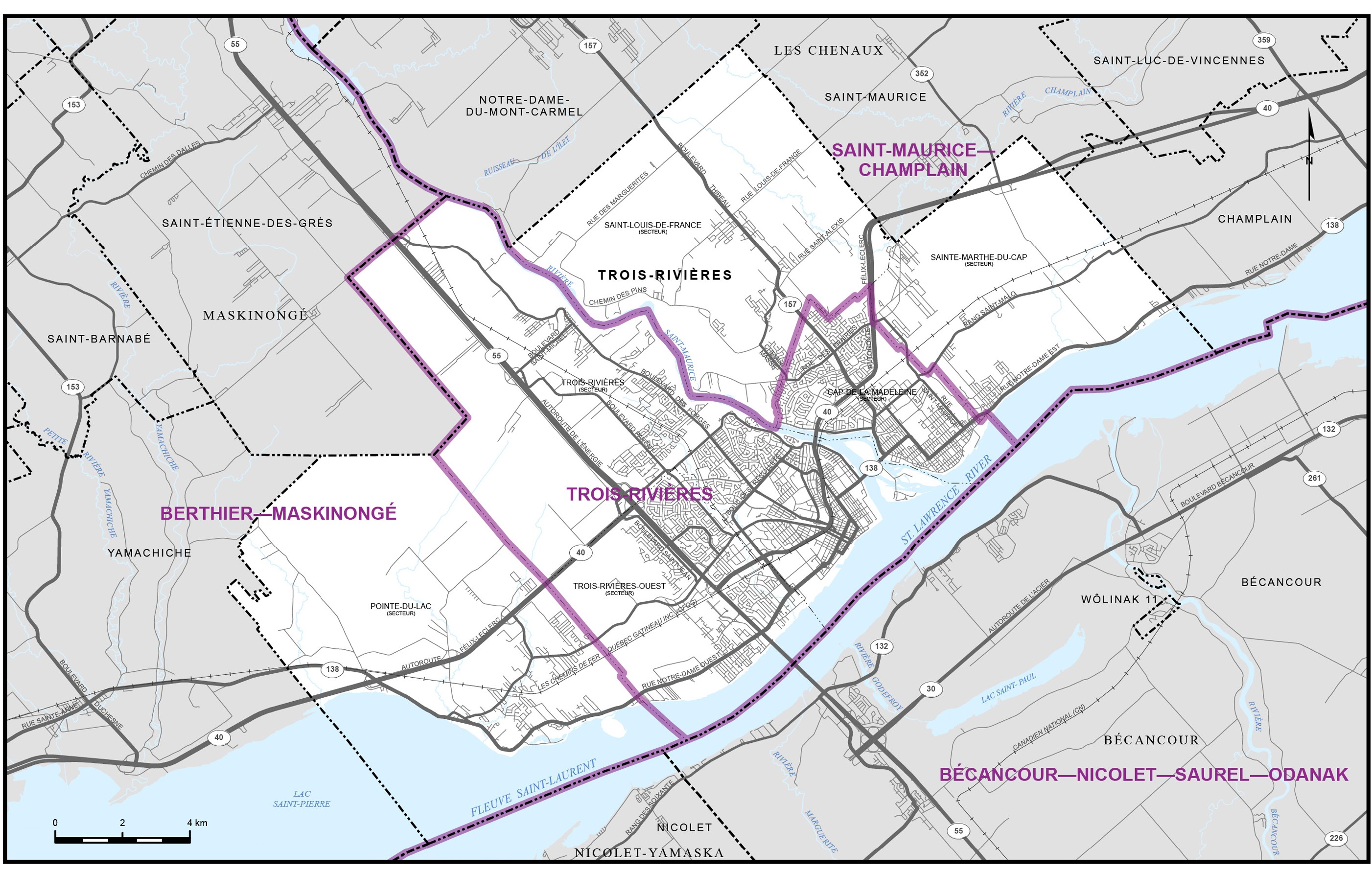
Pontiac to Saint-Maurice—Champlain
The vast area of the north shore of the St. Lawrence River from Pontiac to Saint-Maurice—Champlain (excluding Abitibi, Nord-du-Québec, Saguenay-Lac-Saint-Jean and Côte-Nord) now has a population of 1,842,894 spread over 16 electoral districts, for an average of 115,180, which is the highest in Quebec. With one exception, none of these districts have seen their population decline since the 2011 census. It is a demographically dynamic area that has seen a 10.7% increase in population in 10 years. Creating a new district would reduce the average population of the whole area to 108,405, which is slightly below the provincial average. If the past is any indication, the overall average will continue to grow faster than the provincial average.
All these data lead the Commission to propose creating a new electoral district in this vast territory.
For added convenience, the proposed changes will be outlined by administrative region, beginning with those where a new district is being proposed.
The Laurentians and Lanaudière
A close examination of the data allows us to identify three neighbouring electoral districts whose population is greater than 120,000 and significantly exceeds the provincial average, namely, Rivière-du-Nord (+12.5%), Laurentides—Labelle (+13.6%) and Mirabel (+22%). The population of the latter district has increased by 28.4% in 10 years, reaching 132,930 people, making it the second most populated electoral district in Quebec. The population increased by 11.2% in Laurentides—Labelle and by 20.1% in Rivière-du-Nord.
| Electoral Districts | 2011 Population | 2021 Population |
|---|---|---|
| Laurentides—Labelle | 111,357 | 123,796 |
| Mirabel | 103,536 | 132,930 |
| Rivière-du-Nord | 102,085 | 122,654 |
| Total | 316,978 | 379,380 |
| Average | 105,659 | 126,460 |
This is the area with the largest surpluses not specific to a particular district. This region is experiencing remarkable population growth. The population of the three electoral districts increased by 19.7% between 2011 and 2021, while the population of Quebec grew by 7.6% during the same period.
It also appears that this upward trend is not going to wane anytime soon. In its population projections for the RCM of Les Pays-d’en-Haut for the period from 2020 to 2041 (June 2021),footnote 3 the ISQ forecasts a 22% population increase, which is slightly more than double the 10.6% increase forecast for the entire Quebec population.
To correct this situation and restore relative voting parity in this territory of sustained population growth, the Commission proposes the creation of a new district. Its territory would include that of the RCM of Les Pays-d’en-Haut, as well as larger or smaller portions of the electoral districts of Argenteuil—La Petite-Nation (Gore, Mille-Îles, Wentworth), Joliette (Entrelacs, Chertsey), Laurentides—Labelle (Val-David, Val-Morin), Mirabel (Saint-Colomban), Montcalm (Saint-Calixte) and Rivière-du-Nord (Prévost (part) and Saint-Hippolyte). The population of the electoral district thus constituted will be 106,091 (-3%).
The Commission is also proposing minor changes to reduce population variances in the Lanaudière region. The electoral district of Repentigny will lose the municipality of Saint-Sulpice in favour of Berthier—Maskinongé, and the neighbourhood of the City of L’Assomption called “Le Domaine-Ouellet,” located in its eastern part, will be transferred to the electoral district of Joliette. Two municipalities of the electoral district of Montcalm (Saint-Liguori and Sainte-Marie-Salomé) would also be transferred to Joliette. In the same vein, part of the territory of the electoral district of Terrebonne would be transferred to that of Thérèse-de-Blainville.
With this addition and these transfers, the population of the electoral districts in the region will range from 103,968 to 113,797, as compared to the current 102,311 to 132,930.
Mauricie
Only one change seems necessary in this region, where variances from the average are small. In order to balance their respective populations and as mentioned above, the Commission proposes transferring the municipality of Saint-Sulpice from the electoral district of Repentigny to that of Berthier—Maskinongé. This change will reduce the population difference between the two districts by half.
The Commission is not proposing any changes for the electoral districts of Saint-Maurice—Champlain and Trois-Rivières.
Outaouais
Following an increase of 22% in 10 years, the population of Pontiac now stands at 129,781 and ranks third among Quebec districts. The +19% variance from the average must be reduced.
The creation of a new electoral district having produced a domino effect in Laurentides—Labelle, the Commission proposes to extend its boundaries to absorb, in whole or in part, municipalities mainly in Pontiac (Val-des-Monts (part), La Pêche (part), Denholm, Low, Lac-Sainte-Marie, Kazabazua, Gracefield, Bouchette, Sainte-Thérèse-de-la-Gatineau, Déléage, Aumond, Grand-Remous), but also from Joliette (Notre-Dame-de-la-Merci, Saint-Donat) and from Argenteuil—La Petite-Nation (Bowman, Val-des-Bois).
The Commission also proposes to transfer a small portion of Pontiac to Hull—Aylmer and to transfer the portion of Gatineau north of Highway 50 to Argenteuil—La Petite-Nation.
As a result of these changes, the population of the three Outaouais districts will range from 103,029 to 105,576, as compared to the current 107,286 to 129,781.
More generally, the population of the electoral districts located in the area from Pontiac to Saint-Maurice—Champlain will range from 103,029 to 114,064 people, as compared to the current 102,311 to 132,930.
*
In concluding this chapter on electoral boundaries, it is interesting to compare the variances resulting from the Commission’s proposal with the variances that existed at the beginning of its work, using the table below.
| Size of variance | The 78 current districts | The 78 proposed districts |
|---|---|---|
| Greater than -25% | 3 | 0 |
| -25% to -15% | 5 | 5 |
| -15% to -10% | 3 | 0 |
| -10% to -2% | 19 | 16 |
| -2% to 2% | 14 | 24 |
| 2% to 10% | 22 | 32 |
| 10% to 15% | 7 | 1 |
| 15% to 25% | 5 | 0 |
| Greater than 25% | 0 | 0 |
| Total number of districts | 78 | 78 |
Under the proposed division, no district deviates from the average by more than 25%, while three of the current districts do so. The number of districts deviating from the average by 10% or more is reduced from 23 to 6. The least populated district has 88,525 people instead of 70,253, and the most populated district has 120,653 instead of 134,555. Finally, the Loosemore-Hanby index (the measure of inequality in an electoral division) falls from 0.0415 to 0.0198, less than half what it was when the Commission began its work.
All the indicators converge to show a reduction in the variances and a greater parity in the electoral power of the population among the districts.
Names of the districts
The Commission’s mission also includes naming each of the districts for which it has established the respective boundaries and populations.
In its Guidelines for the Selection of Federal Electoral District Names (November 2021), the Geographical Names Board of Canada writes
The name of a federal electoral district should only be kept from one readjustment to another if it is suitable and if the new district falls essentially within the boundaries of the former electoral district. When the boundaries of an electoral district are changed considerably, one must, without question, consider assigning it another name.
The Geographical Names Board of Canada also recommends that the names selected be those that “immediately lead one to recall the region or the part of the province” in which the districts are situated, ideally geographical names.
The proposed name changes are consistent with these guidelines.
Most of the changes result from the Commission’s desire that the electoral map better reflect the presence of Indigenous peoples in Quebec.
The idea is not new, as the electoral district of Abitibi—Baie-James—Nunavik—Eeyoufootnote 4 has, for several years now, recognized the presence of Inuit (Nunavik) and the Cree (Eeyou) on the territory.
What is new is that we hope that the electoral map will, for the first time, reflect the presence of all the recognized Indigenous nations in Quebec; that is, 10 First Nations and the Inuit Nation. It is a matter of recognizing their rightful place not only in the reality of Quebec today, but also in its history. The Commission sees this as a further step toward ensuring that “reconciliation becomes a reality” in the words of the Truth and Reconciliation Commission of Canada in its final report (Volume 6, Closing words, p. 218). The electoral map would henceforth include at least one reference, generally geographical, to each of the 11 Indigenous nations that make up 55 communities in Quebec, including 14 northern villages.
As this is to be viewed as a reconciliatory initiative, there is no question of the Commission proposing a change that a community would not want. It goes without saying, however, that wide, or even unanimous, agreement of the nations would make the impact of an electoral map designed to give greater prominence to Indigenous nations all the more eloquent and powerful.
In this context, the Chair of the Commission contacted by telephone and/or email the Indigenous communities located in the electoral districts whose names would be changed by adding a reference to them. He took advantage of this first contact to explain the Commission’s project and to invite the leaders of these communities to give him their reaction. To date, not all communities have responded, but two have; one positively (Wolastoqiyik (Maliseet) Wahsipekuk First Nation) and the other negatively (Huron-Wendat First Nation). The Commission took note of this refusal and, with regret, did not include in its proposal the recommendation that the name Wendake be henceforth part of the name of the electoral district of Charlesbourg—Haute-Saint-Charles.
The release of the proposal marks the beginning of a public consultation period, and the Commission is taking this opportunity to once again invite feedback on the proposed name changes from the Indigenous communities involved.
In closing, it is important to note that the addition of an Indigenous reference to the name of a particular electoral district should not be perceived, or interpreted, as the Commission taking a position on any claim to the territory of that electoral district or any territory by the Indigenous nation to which the reference relates or by any Indigenous nation.
The Commission is proposing varying degrees of boundary changes for some 60 electoral districts. All these changes, as well as the desire to better reflect the Indigenous presence in Quebec, lead the Commission to propose the modification of the names of 12 of the 78 electoral districts.
| Current Name | Proposed Name |
|---|---|
| Beauport—Côte-de-Beaupré—Île d’Orléans—Charlevoix | Côte-de-Beaupré—Île d’Orléans—Charlevoix |
| Bécancour—Nicolet—Saurel | Bécancour—Nicolet—Saurel—Odanak |
| Châteauguay—Lacolle | Châteauguay—Les Jardins-de-Napierville |
| Gaspésie—Les Îles-de-la-Madeleine | Gaspésie—Les Îles-de-la-Madeleine—Listuguj |
| Joliette | Joliette—Manawan |
| La Prairie | La Prairie—Atateken |
| Manicouagan | Manicouagan—Kawawachikamach—Uapishka |
| Montmagny—L’Islet—Kamouraska—Rivière-du-Loup | Montmagny—Témiscouata—Kataskomiq |
| Pontiac | Pontiac—Kitigan Zibi |
| Rimouski-Neigette—Témiscouata—Les Basques | Rimouski—Matane |
| Salaberry—Suroît | Salaberry—Suroît—Soulanges |
| Vaudreuil—Soulanges | Vaudreuil |
The reasons for the name changes are set out later in the Appendix.
The newly created electoral district in the Laurentians is called Les Pays-d’en-Haut.
The other districts retain their names.
The 78 districts are presented and described in the Appendix, in alphabetical order.
Those wishing to make representations at a Commission hearing, either in person or virtually, are directed to the rules of procedure (Part IV) and the schedule of hearings (Part VI).
Part IV – Rules of Procedure
The following rules of procedure were adopted by the Federal Electoral Boundaries Commission for Quebec under authority of section 18 of the Electoral Boundaries Readjustment Act, R.S.C. 1985, Chapter E-3.
- 1. The following terms shall be interpreted as follows:
- a) “Act”: the Electoral Boundaries Readjustment Act, R.S.C. 1985, Chapter E-3, as amended;
- b) “advertisement”: an advertisement or notice published pursuant to subsections 19(2) and (3) of the Act and giving notice of the date, time and place of the Commission’s public sittings;
- c) “Chair”: the Chair of the Commission or the Deputy Chair, as the case may be;
- d) “Commission”: the Federal Electoral Boundaries Commission established for Quebec pursuant to section 3 of the Act;
- e) “notice”: the notice in writing that must be addressed to the Commission Secretary by any person interested in making representations within 23 days of the date of publication of the last advertisement, as required by subsection 19(5) of the Act;
- The form available at redecoupage-redistribution-2022.ca duly completed and submitted within the above-mentioned time limit, shall be deemed to be a notice within the meaning of these rules of procedure.
- In the case of a representation relating to the boundaries of an electoral district, it may be submitted using the interactive mapping tool available at redecoupage-redistribution-2022.ca within the timeframe mentioned above.
- f) “person”: any individual or legal entity, whether under public or private law;
- g) “representation”: a representation made by a person with an interest in the geographical boundaries or in the names of one or more electoral districts in Quebec;
- h) “Secretary”: the person who acts as Commission Secretary, so named pursuant to subsection 16(2) of the Act; and
- i) “sitting”: a public sitting held by the Commission under section 19 of the Act.
- 2. For the purpose of abiding by the 23-day limit prescribed by subsection 19(5) of the Act, the postmark on a mailed notice and the date of receipt by the Commission appearing on the notice sent by electronic means will establish the date it was given.
- 3. Any person who wishes to make representations at a sitting within the meaning of Rule 1, paragraph (e) must give notice of their intentions in accordance with Rule 1, paragraph (b) and Rule 4.
- Any message received by the Commission via social media, telephone, or any means other than as provided in Rule 3, and in Rule 1, paragraph (b) does not constitute a notice or representation within the meaning of the Act and these rules and therefore will not be considered.
- 4. The notice must indicate:
- a) the name and address of the person who wishes to make representations, including, where available, the person’s email address;
- b) the nature of the representations;
- c) the nature of the interest in question;
- d) the grounds for the representations concerning the boundaries and the name of the electoral district;
- e) the relevant references and documentation (e.g., the proposed map) that the person intends to cite or communicate; and
- f) the in-person or virtual sitting of the Commission at which the person wishes to be heard, and the official language in which the person wishes to be heard.
- The text of the notice is presented on the front of the pages, on white letter-size paper (21.5 cm x 28 cm), with at least one and one-half line spacing. The margins must not be smaller than 2.5 cm. The computer typeface is 12 point. Font is Arial size 12 or a font that is no more than 12 characters per 2.5 cm.
- The notice should not be more than 10 pages.
- The Commission reserves the right to reject, and return to the originator, notices that do not comply with the requirements of this rule or that do not address a subject matter within the Commission’s jurisdiction. The Commission also reserves the right not to hear, for a reason related to preserving the integrity of the consultation process, a person who wished to be heard.
- 5. The quorum required for a sitting of the Commission is two members.
- 6. Any person who requires special arrangements to be made so that the person can make representations at a sitting must inform the Commission Secretary thereof in a timely manner.
- 7. Any person who wishes to make representations at a sitting can be represented by only one person, unless the Commission decides otherwise.
- 8. The Commission shall prepare a hearing list, indicating for each person to be heard the time scheduled for their input and the time allotted to them. The Commission Secretary shall provide this hearing list to the persons who will be heard.
- 9. The Commission Chair, or, if applicable, the member presiding over the sitting, shall take the necessary steps to ensure decorum and respect for the participants.
- 10. If a sitting cannot be held or the representations cannot be completed within the scheduled time, the Chair may postpone or, where appropriate, adjourn the sitting. The Secretary shall then give notice of the date, time and place of the new sitting to the interested persons.
- 11. Subject to the mandatory provisions of the Act, the Commission may exempt a person who wishes to make a representation from compliance with a provision of these rules if the circumstances and the public interest warrant it.
Montréal, July 15, 2022.
The Honourable Jacques Chamberland
Chair
retired Justice of the Quebec Court of Appeal
André Blais
Member
Full Professor
Louis Massicotte
Member
retired Full Professor
Part V – Reminder of Mandatory Terms and Conditions
The Act specifically states that the Commission shall not hear, during its public sittings, representations for which written notice has not been given in accordance with section 19(5) of the Act, unless the Commission considers it to be in the public interest to do so.
The notice must be forwarded no later than August 31, 2022, and addressed to:
Johanne Dumont
Commission Secretary
Federal Electoral Boundaries Commission for Quebec
By mail to:
PO Box 829, Saint-Dominique
Montréal, Quebec H2S 3M4
By email to:
QC@redecoupage-federal-redistribution.ca
Notices may also be submitted electronically by completing the required form at redistribution2022.ca, by selecting the province and then clicking on “Public Hearings.”
Any oral or written submission or representation made to the Federal Electoral Boundaries Commission for Quebec is deemed to be a public submission. Therefore, it is accessible to the general public and may be included in the Commission’s reports, published by the Chief Electoral Officer of Canada and posted on the Internet.
Part VI – Dates and Locations of Public Hearings
| Location | Place of hearing | Date of hearing | Time of hearing |
|---|---|---|---|
| Gaspé | Hôtel Baker 278 Reine Street |
September 6, 2022 | 9 a.m. |
| Matane | Hôtel-Motel La Vigie 600 Phare Avenue West |
September 7, 2022 | 9 a.m. |
| Rimouski | Hôtel Rimouski 225 René-Lepage Boulevard East |
September 8, 2022 | 9 a.m. |
| Riviere-du-Loup | Hôtel Universel 311 Hôtel-de-Ville Boulevard |
September 9, 2022 | 9 a.m. |
| Montréal | Hôtel Intercontinental 360 Saint-Antoine Street |
September 12, 2022 | 1 p.m. |
| Montréal | Hôtel Intercontinental 360 Saint-Antoine Street |
September 13, 2022 | 9 a.m. |
| Virtual hearing | The link will be provided to participants. | September 14, 2022 | 9 a.m. |
| Saguenay | Hôtel Le Montagnais 1080 Talbot Boulevard |
September 19, 2022 | 9 a.m. |
| Lévis | Sheraton Lévis (Centre des congrès) 5800 J.-B.-Michaud Street |
September 20, 2022 | 10 a.m. |
| Québec | Hôtel Travelodge 3125 Hochelaga Boulevard |
September 21, 2022 | 9 a.m. |
| Trois-Rivières | Holiday Inn Express & Suites 2000 Grands-Marchés Street |
September 22, 2022 | 10 a.m. |
| Laval | Sheraton (Palais des congrès) 2440 Laurentides Highway |
September 26, 2022 | 1:30 p.m. |
| Saint-Jérôme | Super 8 (Wyndham) 3 John-F.-Kennedy Street |
September 27, 2022 | 9:30 a.m. |
| Sainte-Adèle | Hôtel Mont-Gabriel 1699 Mont-Gabriel Road |
September 28, 2022 | 9 a.m. |
| Gatineau | Hôtel Four Points 35 Laurier Street |
September 29, 2022 | 9 a.m. |
| Val-d’Or | Le Forestel 1001 3e Avenue East |
September 30, 2022 | 9 a.m. |
| Sallaberry-de-Valleyfield | Palais de justice de Salaberry-de-Valleyfield 74 Académie Street |
October 3, 2022 | 9:30 a.m. |
| Longueuil | Holiday Inn Longueuil 900 Saint-Charles Street East |
October 4, 2022 | 9:30 a.m. |
| Sherbrooke | Delta Sherbrooke 2685 King Street West |
October 5, 2022 | 9 a.m. |
| Thetford Mines | Hôtel du Domaine 755 9e Street South |
October 6, 2022 | 9 a.m. |
| Sept-Îles | Quality Inn & Suites 1009 Laure Boulevard |
October 11, 2022 | 9 a.m. |
| Virtual hearing | The link will be provided to participants. | October 13, 2022 | 9 a.m. |
Appendix – Maps, Proposed Boundaries and Names of Electoral Districts
This publication contains a map of the Province of Quebec, four (4) maps for Southern and Eastern Quebec, individual maps of cities consisting of more than one electoral district, and a map and description of each of the province’s seventy-eight (78) electoral districts.
The sources used in the preparation of the maps in this atlas are from Natural Resources Canada (Canada Centre for Remote Sensing) and Statistics Canada (Geography Division).
The following definitions apply to all the descriptions in this publication:
- (a) for the purposes of describing electoral districts, the term “regional county municipality” means a corporation having jurisdiction over a territory in respect of which letters patent have been issued pursuant to the provisions of Division 1, Chapter 1, Title II of the Land Use Planning and Development Act (c. A 19.1 of the Revised Statutes of Quebec) following the coming into force of section 12.1 (S.Q. 1979, c. 51, s. 251) of the Territorial Division Act (c. D 11 of the Revised Statutes of Quebec);
- (b) reference to “boulevard”, “road”, “street”, “estuary”, “river”, “highway”, “avenue”, “railway”, “transmission line”, “channel”, “bridge”, “canal”, “crescent”, “basin”, or “tributary” signifies their centre line unless otherwise described;
- (c) all villages, parishes, cities and Indian reserves lying within the perimeter of an electoral district are included, unless otherwise described;
- (d) all First Nations territories lying within the perimeter of the electoral district are included, unless otherwise described;
- (e) wherever a word or expression is used to designate a territorial division, that word or expression designates the territorial division as it existed or was delimited on the first day of January, 2021;
- (f) the translation of the terms “street”, “avenue” and “boulevard” follows Treasury Board standards, while the translation of all other public thoroughfare designations is based on commonly used terms but has no official recognition.
The population figure of each electoral district is derived from the 2021 decennial census conducted by Statistics Canada.
Abitibi—Baie-James—Nunavik—Eeyou
(Population: 89,087)
(Map 1)
Reason: The words Nunavik and Eeyou, which already form the name of the district, remind us that Inuit and Cree people inhabit this vast northern territory, from the shores of James Bay and Hudson Bay to Nunavik, north of the 55th parallel. In 1975, the Cree, Inuit and the governments of Quebec and Canada signed the James Bay and Northern Quebec Agreement.
Consists of:
- (a) the Regional County Municipality of La Vallée-de-l’Or, including: the Lac-Simon Indian Reserve and the Kitcisakik Indian settlement;
- (b) the Territory of the Eeyou Istchee Baie-James Regional Government, including: the Cree village municipalities and the Cree reserved lands of Chisasibi, Eastmain, Mistissini, Nemaska, Waskaganish, Waswanipi and Wemindji; the Amerindian settlement of Oujé-Bougoumou;
- (c) the Territory of the Kativik Regional Administration, including: the Cree Village Municipality and the Cree Reserved Land of Whapmagoostui; the Nordic village municipalities of Akulivik, Aupaluk, Inukjuak, Ivujivik, Kangiqsualujjuaq, Kangiqsujuaq, Kangirsuk, Kuujjuaq, Kuujjuarapik, Puvirnituq, Quaqtaq, Salluit, Tasiujaq and Umiujaq; the Naskapi Village Municipality of Kawawachikamach.
Abitibi—Témiscamingue
(Population: 103,735)
(Map 1)
Consists of:
- (a) the City of Rouyn-Noranda;
- (b) the Regional County Municipality of Témiscamingue, including: Timiskaming and Kebaowek Indian reserves; Hunter’s Point (Wolf Lake) and Winneway Indian settlements;
- (c) the Regional County Municipality of Abitibi-Ouest;
- (d) the Regional County Municipality of Abitibi, including the Pikogan Indian Reserve.
Ahuntsic—Cartierville
(Population: 111,511)
(Map 12)
Consists of that part of the City of Montréal comprising that part of the borough of Ahuntsic-Cartierville lying southwesterly of Papineau Avenue and Highway 19 (Papineau Highway), with the exception of the area lying southerly of a line described as follows: commencing at the intersection of said borough and Henri-Bourassa Boulevard West; thence northeasterly along said boulevard to L’Acadie Boulevard; thence generally southeasterly along said boulevard to the southeasterly limit of the borough of Ahuntsic-Cartierville.
Alfred-Pellan
(Population: 113,173)
(Map 8)
Consists of that part of the City of Laval lying northeasterly of a line described as follows: commencing at the intersection of the northwesterly limit of said city and Papineau Avenue (Athanase-David Bridge); thence southeasterly along said avenue to des Lacasse Avenue and its production; thence southwesterly along said avenue to des Laurentides Boulevard; thence southeasterly along said boulevard to the southeasterly limit of the City of Laval.
Argenteuil—La Petite-Nation
(Population : 105 697)
(Maps 2 and 3)
Consists of:
- (a) that part of the Regional County Municipality of Argenteuil comprising: the cities of Brownsburg-Chatham and Lachute; the municipalities of Grenville-sur-la-Rouge and Saint-André-d’Argenteuil; the Township Municipality of Harrington; the Village of Grenville;
- (b) the Regional County Municipality of Papineau, with the exception of the municipalities of Bowman and Val-des-Bois;
- (c) that part of the Regional County Municipality of des Collines-de-l’Outaouais comprising the Municipality of L’Ange-Gardien and that part of the Municipality of Val-des-Monts lying easterly of the main highway (Highways 366 and 307);
- (d) that part of the City of Gatineau described as follows: commencing at the intersection of northerly limit of said city and montée Paiement; thence southerly along montée Paiement to Highway 50 (Autoroute de l’Outaouais); thence easterly along said highway to montée Mineault; thence northerly along montée Mineault to the northerly limit of the City of Gatineau; thence generally northerly and westerly along the limit of said city to the point of commencement;
- (e) that part of the City of Mirabel lying northwesterly of a line described as follows: commencing at the intersection of the westerly limit of said city and Lalande Road; thence northeasterly along said road and Clément-Pesant Road to Highway 148; thence generally southeasterly to Saint-Simon Road; thence generally northeasterly along said road to the northerly limit of the City of Mirabel; and
- (f) that part of the Regional County Municipality of des Laurentides comprising that part of the Township Municipality of Amherst lying southerly of Highway 323.
Beauce
(Population: 111,034)
(Map 4)
Consists of:
- (a) the regional county municipalities of Beauce-Sartigan and Robert-Cliche;
- (b) the Regional County Municipality of la Nouvelle-Beauce, with the exception of the Municipality of Saint-Lambert-de-Lauzon; and
- (c) that part of the Regional County Municipality of des Etchemins comprising the municipalities of Sainte-Aurélie, Saint-Benjamin, Saint-Prosper and Saint-Zacharie.
Beauport—Limoilou
(Population: 109,495)
(Map 14)
Consists of that part of the City of Québec comprising:
- (a) that part of the borough of La Cité-Limoilou lying northerly of the Saint-Charles River and its estuary, with the exception of that part lying southerly of a line described as follows: commencing at the intersection of Laurentienne Highway and Wilfrid-Hamel Boulevard; thence northeasterly along said boulevard to Eugène-Lamontagne Avenue; thence northeasterly along said avenue to 1st Avenue; thence southeasterly along said avenue to de la Croix-Rouge Street; thence southwesterly along said street to the Saint-Charles River;
- (b) that part of the borough of Beauport lying southerly of a line described as follows: commencing at the intersection of the western limit of said borough with Louis-XIV Boulevard; thence generally easterly along said boulevard to de la Sérénité Street; thence generally northeasterly along said street and its production to the western limit of the Municipality of Boischatel; and
- (c) that part of the borough of Charlesbourg lying easterly and southeasterly of a line described as follows: commencing at the intersection of the eastern limit of said borough with de Chamonix Street; thence generally southwesterly along said street to 10th Avenue; thence northwesterly along said avenue to Louis-XIV Boulevard; thence generally northeasterly along said boulevard to the eastern limit of the borough of Charlesbourg.
Bécancour—Nicolet—Saurel—Odanak
(Population: 100,252)
(Map 3 and 4)
Reason: The name of the Odanak Indian Reserve is added to the current name of the district to reflect the presence of the Waban-Aki First Nation on this territory. Members of the large Algonquian linguistic and cultural family, the Abenaki of Quebec are originally from the present-day American states of Maine, New Hampshire and Vermont.
Consists of:
- (a) the Regional County Municipality of Nicolet-Yamaska, including Odanak Indian Reserve No. 12;
- (b) the Regional County Municipality of Pierre-De Saurel;
- (c) the Regional County Municipality of Bécancour, including Wôlinak Indian Reserve No. 11; and
- (d) that part of the Regional County Municipality of Drummond comprising: the municipalities of Saint-Eugène and Saint-Guillaume; the parish municipalities of Saint-Pie-de-Guire and Sainte-Brigitte-des-Saults.
Bellechasse—Les Etchemins—Lévis
(Population: 114,366)
(Map 4)
Consists of:
- (a) the Regional County Municipality of Bellechasse, with the exception of the Municipality of Saint-Henri;
- (b) the Regional County Municipality of Les Etchemins, with the exception of the municipalities of Sainte-Aurélie, Saint-Benjamin, Saint-Prosper and Saint-Zacharie; and
- (c) that part of the City of Lévis comprising:
- (i) the borough of Desjardins;
- (ii) that part of the borough of Chutes-de-la-Chaudière-Est lying northerly of a line described as follows: commencing at the intersection of the westerly limit of said borough with Highway 20 (Jean-Lesage Highway); thence generally easterly along said highway to the Etchemin River; then generally southerly and easterly along said river to the easterly limit of the borough of Chutes-de-la-Chaudière-Est.
Beloeil—Chambly
(Population: 114,551)
(Map 3)
Consists of:
- (a) that part of the Regional County Municipality of Rouville comprising: the cities of Marieville and Richelieu; the Municipality of Saint-Mathias-sur-Richelieu;
- (b) that part of the Regional County Municipality of Vallée-du-Richelieu comprising: the cities of Beloeil, Chambly, Mont-Saint-Hilaire and Otterburn Park; the municipalities of McMasterville and Saint-Jean-Baptiste; and
- (c) that part of the area of Sainte-Thérèse in the City of Carignan.
Berthier—Maskinongé
(Population: 108,640)
(Maps 2 and 3)
Consists of:
- (a) the regional county municipalities of D’Autray and Maskinongé;
- (b) that part of the Regional County Municipality of Matawinie comprising: the municipalities of Saint-Félix-de-Valois and Saint-Jean-de-Matha; the Parish Municipality of Saint-Damien;
- (c) that part of the Regional County Municipality of L’Assomption comprising the Parish Municipality of Saint-Sulpice; and
- (d) that part of the City of Trois-Rivières comprising the area of Pointe-du-Lac.
Bourassa
(Population: 105,637)
(Map 12)
Consists of that part of the City of Montréal comprising:
- (a) that part of the borough of Ahuntsic-Cartierville lying northeasterly of Papineau Avenue and Highway 19 (Papineau Highway); and
- (b) the borough of Montréal-Nord.
Brome—Missisquoi
(Population: 113,913)
(Map 3)
Consists of:
- (a) the Regional County Municipality of Brome-Missisquoi;
- (b) that part of the Regional County Municipality of Haut-Richelieu comprising: the municipalities of Saint-Sébastien, Henryville, Noyan, Saint-Georges-de-Clarenceville and Venise-en-Québec; and
- (c) that part of the Regional County Municipality of Memphrémagog comprising: the City of Magog; the Village Municipality of Stukely-Sud; the municipalities of Austin, Bolton-Est, Eastman, Saint-Benoît-du-Lac and Saint-Étienne-de-Bolton; the township municipalities of Potton and Orford.
Brossard—Saint-Lambert
(Population: 114,286)
(Maps 10 and 13)
Consists of the cities of Brossard and Saint-Lambert.
Charlesbourg—Haute-Saint-Charles
(Population: 110,320)
(Map 14)
Consists of the Wendake Indian Reserve and that part of the City of Québec comprising:
- (a) that part of the borough of Charlesbourg lying westerly of a line described as follows: commencing at the intersection of the easterly limit of said borough with de Chamonix Street; thence generally southwesterly along said street to 10th Avenue; thence generally northwesterly along said avenue to Louis-XIV Boulevard; thence generally northeasterly along said boulevard to du Loiret Boulevard; thence generally northwesterly along said boulevard to de Château-Bigot Road; thence generally northeasterly, northerly and northwesterly along the production of said road to a point at latitude 46°54′58″N and longitude 71°15′43″W (des Roches River);
- (b) that part of the borough of La Haute-Saint-Charles lying northeasterly of a line described as follows: commencing at the intersection of the northerly limit of the City of Québec with Valcartier Boulevard; thence generally southeasterly along said boulevard to Racine Street; thence generally northeasterly and northerly along said street to Bastien Boulevard; thence generally easterly along said boulevard to the southeasterly limit of the borough of La Haute-Saint-Charles (Auguste-Renoir Street);
- (c) that part of the borough of des Rivières lying northerly of a line described as follows: commencing at the intersection of the northern limit of said borough with Bastien Boulevard and Auguste-Renoir Street; thence generally southeasterly along Bastien Boulevard to Pierre-Bertrand Boulevard; thence generally southeasterly along said boulevard to Highway 40 (Félix-Leclerc Highway); thence northeasterly along said highway to the easterly limit of the borough of des Rivières.
Châteauguay—Les Jardins-de-Napierville
(Population: 114,947)
(Map 3)
Reason: It is a matter of correcting an error made when the name Châteauguay—Lacolle was attributed to this electoral district, the municipality of Lacolle being instead in the neighbouring electoral district of Saint-Jean. A public bill to this effect was passed by the Senate on February 8, 2022, but is still pending in the House. Les Jardins-de-Napierville refers to the name of the RCM of the same name that occupies a large part of the district’s territory.
Consists of:
- (a) the Regional County Municipality of Les Jardins-de-Napierville;
- (b) that part of the Regional County Municipality of Beauharnois-Salaberry comprising the municipalities of Sainte-Martine and Saint-Urbain-Premier;
- (c) that part of the Regional County Municipality of Roussillon comprising the cities of Châteauguay, Léry and Mercier; the Parish Municipality of Saint-Isidore;
- (d) that part of the Regional County Municipality of Le Haut-Saint-Laurent comprising the municipalities of Franklin, Saint-Chrysostome and Howick; the Parish Municipality of Très-Saint-Sacrement; the Township Municipality of Havelock.
Chicoutimi—Le Fjord
(Population: 92,460)
(Maps 1 and 15)
Consists of:
- (a) that part of the Regional County Municipality of Fjord-du-Saguenay comprising: the City of Saint-Honoré, the municipalities of Ferland-et-Boilleau, L’Anse-Saint-Jean, Petit-Saguenay, Rivière-Éternité, Saint-Félix-d’Otis, Saint-Fulgence and Saint-David-de-Falardeau; the Parish Municipality of Sainte-Rose-du-Nord; the unorganized territory of Lalemant; and
- (b) that part of the City of Saguenay comprising:
- (i) the borough of La Baie;
- (ii) that part of the borough of Chicoutimi lying northeasterly of a line described as follows: commencing at the intersection of the northwesterly limit of said borough with Highway 70; thence generally southeasterly along said highway, du Royaume Boulevard East and Highway 170 to the southeasterly limit of the borough of Chicoutimi.
Compton—Stanstead
(Population: 113,282)
(Maps 3 and 4)
Consists of:
- (a) the regional county municipalities of Coaticook and Haut-Saint-François;
- (b) that part of the Regional County Municipality of Val-Saint-François comprising the Municipality of Stoke;
- (c) that part of the Regional County Municipality of Memphrémagog comprising: the City of Stanstead; the village municipalities of Ayer’s Cliff and North Hatley; the municipalities of Hatley, Ogden and Sainte-Catherine-de-Hatley; the township municipalities of Hatley and Stanstead;
- (d) that part of the City of Sherbrooke comprising the boroughs of Brompton–Rock Forest–Saint-Élie–Deauville, Lennoxville and a part of the borough of des Nations lying southerly and easterly of a line described as follows: commencing at the intersection of the southerly limit of said borough and Belvédère Sud Street; thence northerly along said street to a point at latitude 45°22′54″N and longitude 71°53′38″W; thence southeasterly in a straight line to the easterly limit of the borough of des Nations.
Côte-de-Beaupré—Île d’Orléans—Charlevoix
(Population: 107,987)
(Maps 1 and 4)
Reason: Since the western part of this electoral district, which included part of the borough of Beauport, has been transferred to that of Beauport—Limoilou, it is appropriate to change its name by removing Beauport.
Consists of:
- (a) the Regional County Municipalities of L’Île-d’Orléans, La Côte-de-Beaupré, Charlevoix-Est and Charlevoix;
- (b) that part of the City of Québec comprising those parts of the boroughs of Beauport and Charlesbourg lying northerly and easterly of a line described as follows: commencing at the intersection of the easterly limit of the borough of Beauport with de la Sérénité Street; thence generally southwesterly along said street to Louis-XIV Boulevard; thence generally northwesterly and southwesterly along said boulevard to du Loiret Boulevard; thence generally northwesterly along said boulevard to de Château-Bigot Road; thence generally northeasterly, northwesterly and northerly along the production of said road to a point at latitude 46°54′58″N and longitude 71°15′43″W (des Roches River);
- (c) that part of the Regional County Municipality of La Jacques-Cartier comprising the City of Sainte-Brigitte-de-Laval and the Municipality of Lac-Beauport.
Dorval—Lachine—LaSalle
(Population: 114,661)
(Map 12)
Consists of:
- (a) the cities of Dorval and L’Île Dorval; and
- (b) that part of the City of Montréal comprising:
- (i) the borough of Lachine;
- (ii) that part of the borough of LaSalle lying northwesterly of a line described as follows: commencing at the intersection of the southerly limit of the borough of Le Sud-Ouest and the former Canadian Pacific Railway (west of Jean-Chevalier Street); thence southwesterly along said railway to Dollard Avenue; thence southeasterly and southerly along said avenue to De La Vérendrye Boulevard; thence generally southwesterly along said boulevard to Airlie Street; thence northwesterly along said street to 90th Avenue; thence southwesterly along said avenue to the southerly limit of the City of Montréal.
Drummond
(Population: 104,154)
(Map 3)
Consists of the Regional County Municipality of Drummond with the exception of the municipalities of Saint-Eugène and Saint-Guillaume; the parish municipalities of Saint-Pie-de-Guire and Sainte-Brigitte-des-Saults.
Gaspésie—Les Îles-de-la-Madeleine—Listuguj
(Population: 104,682)
(Map 5)
Reason: The name of the Listuguj Indian Reserve is added to the current name of the district to reflect the presence of the Mi’kmaq First Nation on its territory. There are three Mi’kmaq communities in the Gaspé Peninsula: Listuguj, Gesgapegiag and Gespeg. In 2001, the three communities joined together to form the Mi’gmawei Mawiomi Secretariat, a political and administrative organization based in Listuguj.
Consists of:
- (a) the regional county municipalities of Bonaventure, La Côte-de-Gaspé, La Haute-Gaspésie and Le Rocher-Percé;
- (b) those parts of the regional county municipalities of La Matanie, La Matapédia and Avignon comprising: the cities of Amqui, Causapscal and Carleton-sur-Mer; the municipalities of Escuminac, Grosses-Roches, Lac-au-Saumon, Maria, Matapédia, Les Méchins, Nouvelle, Pointe-à-la-Croix, Saint-Alexis-de-Matapédia, Saint-André-de-Restigouche, Saint-René-de-Matane, Saint-Vianney, Sainte-Félicité, Sainte-Florence, Saint-François-d’Assise and Sainte-Marguerite-Marie; the parish municipalities of Saint-Adelme, Saint-Alexandre-des-Lacs, Saint-Jean-de-Cherbourg and Saint-Tharcisius; the unorganized territories of Lac-Casault, Ruisseau-des-Mineurs, Rivière-Bonjour, Rivière-Nouvelle and Routhierville; the Township Municipality of Ristigouche-Partie-Sud-Est; the Indian reserves of Listuguj and Gesgapegiag; and
- (c) the Equivalent Territory of Les Îles-de-la-Madeleine comprising the municipalities of Grosse-Île and Les Îles-de-la-Madeleine.
Gatineau
(Population: 103,029)
(Map 7)
Consists of that part of the City of Gatineau described as follows: commencing at the intersection of the Gatineau River (northerly limit of said city) and du Pont Avenue; thence generally southeasterly along the Gatineau River to the southerly limit of the City of Gatineau (Ottawa River); thence generally easterly along said limit and river to the easterly limit of the area of Gatineau; thence northerly along said limit to Highway 50 (Autoroute de l’Outaouais); thence generally westerly and southerly to La Vérendrye Boulevard; thence northwesterly and southwesterly along said boulevard and du Pont Avenue to the point of commencement (Alonzo-Wright Bridge).
Hochelaga
(Population: 113,984)
(Map 12)
Consists of that part of the City of Montréal comprising:
- (a) that part of the borough of Mercier-Hochelaga-Maisonneuve lying southwesterly of a line described as follows: commencing at the intersection of the southeasterly limit of the City of Montréal and the southeasterly production of Haig Avenue; thence northwesterly along said production and said avenue to Hochelaga Street; thence southwesterly along said street to Langelier Boulevard; thence northwesterly along said boulevard to Sherbrooke Street East; thence northeasterly along said street to the power transmission line located between du Trianon Street and Des Groseilliers Street; thence northwesterly along said transmission line to the westerly limit of said borough; thence generally southwesterly and northwesterly along the limit of said borough to Beaubien Street East; thence southwesterly along said street to Langelier Boulevard; thence northwesterly along said boulevard to the westerly limit of the borough of Mercier-Hochelaga-Maisonneuve;
- (b) that part of the borough of de Rosemont-La Petite-Patrie lying northeasterly of Pie-IX Boulevard and southeasterly of Bélanger Street; and
- (c) that part of the borough of Ville-Marie lying northeasterly of a line described as follows: commencing at the intersection of the northerly limit of said borough and Hochelaga Street; thence southwesterly along said Street to Frontenac Street; thence southeasterly along said street and its production to the easterly limit of the borough of Ville-Marie.
Honoré-Mercier
(Population: 105,593)
(Map 12)
Consists of that part of the City of Montréal comprising:
- (a) the borough of Anjou;
- (b) that part of the borough of Rivière-des-Prairies–Pointe-aux-Trembles lying westerly of a line described as follows: commencing at the intersection of the northeasterly limit of the City of Montréal-Est and Henri-Bourassa Boulevard East; thence northeasterly along said boulevard to Highway 40 (Métropolitaine Highway); thence northerly along said highway to the northerly limit of the City of Montréal;
- (c) that part of the borough of Mercier-Hochelaga-Maisonneuve lying northeasterly of Langelier Boulevard and northwesterly of Beaubien Street East; and
- (d) that part of the borough of Saint-Léonard lying northeasterly of a line described as follows: commencing at the intersection the easterly limit of said borough and Langelier Boulevard; thence northwesterly along said boulevard and its production to the westerly limit of the borough of Saint-Léonard.
Hull—Aylmer
(Population: 105,576)
(Map 7)
Consists of:
- (a) that part of the Municipality of Chelsea lying southerly and easterly of a line described as follows: commencing at the intersection of Alonzo-Wright Road and Highway 105; thence northwesterly along said road to a point at approximate latitude 45°29′03″N and longitude 75°45′16″W; thence generally southerly in a straight line to the southeasterly limit of the Municipality of Chelsea at approximate latitude 45°28′44″N and longitude 75°45′15″W; and
- (b) that part of the areas of Hull and Aylmer in the City of Gatineau lying southerly and easterly of a line described as follows: commencing at the intersection of the westerly limit of said city with Eardley Road; thence southeasterly along said road to des Allumettières Boulevard; thence generally easterly along said boulevard to Saint-Raymond Boulevard; thence northerly and easterly along said boulevard to the Gatineau Parkway; thence generally northwesterly following said parkway to the northerly limit of the City of Gatineau.
Joliette—Manawan
(Population: 108,169)
(Maps 2 and 3)
Reason: The name of the Manawan Indian Reserve is added to the current name of the electoral district to reflect the presence of the Atikamekw First Nation on its territory. There are three Atikamekw communities in Quebec: Manawan, Opitciwan and Wemotaci.
Consists of:
- (a) the Regional County Municipality of Joliette;
- (b) that part of the Regional County Municipality of Matawinie comprising: the municipalities of Rawdon, Saint-Alphonse-Rodriguez, Saint-Côme, Saint-Michel-des-Saints, Saint-Zénon, Sainte-Béatrix, Sainte-Émélie-de-l’Énergie and Sainte-Marcelline-de-Kildare; the unorganized territories of Baie-Atibenne, Baie-de-la-Bouteille, Lac-Devenyns, Lac-des-Dix-Milles, Lac-Legendre, Lac-Matawin, Lac-Minaki, Lac-Santé and Saint-Guillaume-Nord; including the Atikamekw Community of the Manawan Indian Reserve;
- (c) that part of the Regional County Municipality of Montcalm comprising the municipalities of Saint-Liguori and Sainte-Marie-Salomé;
- (d) that part of the City of L’Assomption lying northerly of a line described as follows: commencing at the intersection of the northeasterly limit of said city with the Quebec-Gatineau Railway; thence southwesterly along said railway to a point situated at approximate latitude 45°52′19″N and longitude 73°26′46″W; thence northwesterly to the corner formed by the northwesterly and southeasterly limits of said city (intersection of du Roy Road and Montée Saint-Gérard).
Jonquière
(Population: 91,061)
(Map 1)
Consists of:
- (a) that part of the Regional County Municipality of Fjord-du-Saguenay comprising: the municipalities of Bégin, Larouche, Saint-Ambroise and Saint-Charles-de-Bourget; the unorganized territories of Mont-Valin and Lac-Ministuk;
- (b) that part of the Regional County Municipality of Lac-Saint-Jean-Est comprising: the municipalities of Hébertville, Labrecque, Lamarche, L’Ascension-de-Notre-Seigneur, Saint-Nazaire and Saint-Bruno; the Village of Hébertville-Station;
- (c) that part of the Regional County Municipality of Maria-Chapdelaine comprising: the municipalities of Saint-Eugène-d’Argentenay, Saint-Ludger-de-Milot and Saint-Stanislas, the Parish Municipality of Saint-Augustin, the Village of Sainte-Jeanne-d’Arc; the unorganized territory of Passes-Dangereuses;
- (d) that part of the City of Saguenay comprising:
- (i) the borough of Jonquière;
- (ii) that part of the borough of Chicoutimi lying southwesterly of a line described as follows: commencing at the intersection of the northwesterly limit of said borough with Highway 70; thence generally southeasterly along said highway, du Royaume Boulevard East and Highway 170 to the southeasterly limit of the borough of Chicoutimi.
La Pointe-de-l’Île
(Population: 110,486)
(Map 12)
Consists of:
- (a) the City of Montréal-Est
- (b) that part of the City of Montréal comprising:
- (i) that part of the borough of Rivière-des-Prairies–Pointe-aux-Trembles lying easterly and southeasterly of a line described as follows: commencing at the intersection of the northermost corner of the City of Montréal-Est and Henri-Bourassa Boulevard East; thence northeasterly along said boulevard to Highway 40 (Métropolitaine Highway); thence northerly along said highway to the northerly limit of the City of Montreal; and
- (ii) that part of the borough of Mercier–Hochelaga-Maisonneuve lying northeasterly of a line described as follows: commencing at the intersection of the southeasterly limit of the City of Montréal with the southeasterly production of Haig Avenue; thence northwesterly along said production and said avenue to Hochelaga Street; thence southwesterly along said street to Langelier Boulevard; thence northwesterly along said boulevard to Sherbrooke Street East; thence northeasterly along said street to the power transmission line located between du Trianon and des Groseilliers streets; thence northwesterly along said transmission line to the westerly limit of the borough of Mercier–Hochelaga-Maisonneuve.
La Prairie—Atateken
(Population: 114,968)
(Map 3)
Reason: The Mohawk word Atateken refers to the concept of brotherhood between human beings or a group of people or nations sharing the same values. It is added to the current name of the district to reflect the presence of the Mohawk First Nation on its territory (the community of Kahnawake) and elsewhere in Quebec (the communities of Akwesasne and Kanesatake). Finally, this addition echoes the 2019 change in the name of Amherst Street in Montréal to Atateken.
Consists of that part of the Regional County Municipality of Roussillon comprising: the cities of Candiac, Delson, La Prairie, Sainte-Catherine, Saint-Philippe and Saint-Constant; the Municipality of Saint-Mathieu; including Kahnawake Indian Reserve No. 14.
Lac-Saint-Jean
(Population: 92,031)
(Map 1)
Consists of:
- (a) the Regional County Municipality of Domaine-du-Roy, including the Mashteuiatsh Indian Reserve;
- (b) the Regional County Municipality of Maria-Chapdelaine with the exception of: the municipalities of Saint-Eugène-D’Argentenay, Saint-Ludger-de-Milot and Saint-Stanislas; the Parish Municipality of Saint-Augustin; the Village of Sainte-Jeanne-d’Arc; the unorganized territory of Passes-Dangereuses;
- (c) that part of the Regional County Municipality of Lac-Saint-Jean-Est comprising: the cities of Alma, Desbiens and Métabetchouan—Lac-à-la-Croix; the municipalities of Saint-Gédéon, Saint-Henri-de-Taillon and Sainte-Monique; the unorganized territories of Belle-Rivière, Lac-Achouakan and Lac-Moncouche.
Lac-Saint-Louis
(Population: 110,093)
(Map 12)
Consists of:
- (a) the cities of Baie-D’Urfé, Beaconsfield, Kirkland, Pointe-Claire and Sainte-Anne-de-Bellevue;
- (b) the Village Municipality of Senneville; and
- (c) that part of the City of Montréal comprising:
- (i) that part of the borough of Pierrefonds-Roxboro lying southwesterly of Jacques-Bizard Boulevard;
- (ii) that part of the borough of L’Île-Bizard–Sainte-Geneviève lying southeasterly of des Prairies River and southwesterly of Jacques-Bizard Boulevard.
LaSalle—Émard—Verdun
(Population: 112,298)
(Map 12)
Consists of that part of the City of Montréal comprising:
- (a) the borough of Verdun, with the exception of Île des Sœurs;
- (b) that part of the borough of LaSalle lying southeasterly of a line described as follows: commencing at the intersection of the southerly limit of the borough of Le Sud-Ouest and the former Canadian Pacific Railway (westerly of Jean-Chevalier Street); thence southwesterly along said former railway to Dollard Avenue; thence southeasterly along said avenue to De La Vérendrye Boulevard; thence westerly along said boulevard to Airlie Street; thence northwesterly along said street to 90th Avenue; thence southwesterly along said avenue and its production to the southerly limit of the City of Montréal; and
- (c) that part of the borough of Le Sud-Ouest lying westerly and southerly of a line described as follows: commencing at the intersection of Pullman Street and Highway 720 (Ville-Marie Highway); thence southwesterly along said highway to Highway 15 (Décarie Highway); thence southeasterly along said highway to Lachine Canal; thence generally northeasterly along said canal to Atwater Avenue; thence southeasterly along said avenue to the limit of the borough of Le Sud-Ouest.
Laurentides—Labelle
(Population: 103,968)
(Map 2)
Consists of:
- (a) the Regional County Municipality of Antoine-Labelle;
- (b) the Regional County Municipality of Les Collines-de-l’Outaouais comprising:
- (i) that part of the Municipality of La Pêche lying easterly of a line described as follows: commencing at the southwesterly corner of the limit of the Township Municipality of Low; thence southwesterly in a straight line to a point at approximately latitude 45°44′47″N and longitude 76°09′28″W; thence generally southerly in a straight line to a point at approximate latitude 45°43′56″N and longitude 76°09′18″W; thence southeasterly in a straight line to the intersection of de la Mine Road and Cléo-Fournier Road; thence generally southerly along Cléo-Fournier Road to Principale Road West (Highway 366); thence generally southeasterly along said road to Highway 105; thence generally southeasterly along said highway to the southerly limit of the Municipality of La Pêche;
- (ii) that part of the Municipality of Val-des-Monts lying westerly of Principale Road (Highways 366 and 307);
- (c) the Regional County Municipality of Les Laurentides, with the exception of the Village of Val-David, the Municipality of Val-Morin and that part of the Township Municipality of Amherst lying southerly and easterly of Highway 323 South and Highway 323 North;
- (d) the Regional County Municipality of Matawinie comprising the municipalities of Notre-Dame-de-la-Merci and Saint-Donat;
- (e) the Regional County Municipality of Papineau comprising the municipalities of Bowman and Val-des-Bois;
- (f) the Regional County Municipality of La Vallée-de-la-Gatineau comprising: the City of Gracefield; the municipalities of Déléage, Denholm, Grand-Remous, Kazabazua, Lac-Sainte-Marie and Sainte-Thérèse-de-la-Gatineau; that part of the Municipality of Bouchette lying easterly of the Gatineau River; the township municipalities of Aumond and Low.
Laurier—Sainte-Marie
(Population: 111,212)
(Map 12)
Consists of that part of the City of Montréal comprising:
- (a) that part of the borough of Le Plateau-Mont-Royal lying northeasterly and southeasterly of a line described as follows: commencing at the intersection of the northwesterly limit of said borough and Saint-Denis Street; thence southeasterly along said street to Duluth Avenue East; thence southwesterly along said avenue and Duluth Avenue West to du Parc Avenue; thence southeasterly along said avenue to the southeasterly limit of the borough of Le Plateau-Mont-Royal; and
- (b) that part of the borough of Ville-Marie bounded as follows: commencing at the intersection of the northwesterly limit of said borough and de Bleury Street; thence southeasterly along said street to Viger Avenue West; thence northeasterly along said avenue and Viger Avenue East to Jacques-Cartier Bridge; thence southeasterly along said bridge to the St. Lawrence River (westerly of Sainte-Hélène Island); thence generally northerly along said river (passing westerly of said island) to the southeasterly production of Frontenac Street; thence northwesterly along said production and Frontenac Street to Hochelaga Street; thence northeasterly along said street to the Canadian Pacific Railway; thence westerly along said railway to Sherbrooke Street East (the northwesterly limit of said borough); thence southwesterly along said street and Sherbrooke Street West to the point of commencement.
Laval—Les Îles
(Population: 107,910)
(Map 8)
Consists of that part of the City of Laval lying westerly of a line described as follows: commencing at the intersection of the southeasterly limit of the City of Laval with the southeasterly production of 83rd Avenue; thence northwesterly along said production and 83rd Avenue to Samson Boulevard; thence northeasterly along said boulevard to Curé-Labelle Boulevard; thence northwesterly along said boulevard to Saint-Martin Boulevard West; thence southwesterly along said boulevard and its production to Highway 13 (Chomedey Highway); thence northwesterly along said highway to Sainte-Rose Boulevard; thence generally westerly along said boulevard to Bellemare Street; thence northwesterly along said street and its production to the northwesterly limit of the City of Laval; including Taillefer Island.
Les Pays-d’en-Haut
(Population: 106,091)
(Map 3)
Reason: The name of this new district evokes the settlement of the Laurentides toward the end of the 19th century, more precisely in what is today the RCM of Les Pays-d’en-Haut. It bears witness to the many challenges overcome by those who have participated in the development of this territory. It also brings to mind “Les belles histoires des pays d’en haut,” the famous television series created by Claude-Henri Grignon based on his novel Un homme et son péché.
Consists of:
- (a) the Regional County Municipality of Les Pays-d’en-Haut;
- (b) that part of the Regional County Municipality of Argenteuil comprising: the Municipality of Mille-Isles; the township municipalities of Gore and Wentworth;
- (c) that part of the Regional County Municipality of Les Laurentides comprising: the Municipality of Val-Morin; the Village of Val-David;
- (d) that part of the Regional County Municipality of Matawinie comprising the municipalities of Chertsey and Entrelacs;
- (e) that part of the Regional County Municipality of Montcalm comprising the Municipality of Saint-Calixte;
- (f) that part of the Regional County Municipality of La Rivière-du-Nord comprising: the City of Saint-Colomban; the Municipality of Saint-Hippolyte; that part of the City of Prévost lying northerly of a line described as follows: commencing at the intersection of the easterly limit of said city and du Lac-Écho Road; thence generally southwesterly along said road to du Curé-Labelle Boulevard; thence northerly and northwesterly along said boulevard to the northwesterly limit of the City of Prévost (Highway 117).
Lévis—Lotbinière
(Population: 111,721)
(Map 4)
Consists of:
- (a) that part of the Regional County Municipality of Lotbinière comprising the municipalities of Leclercville, Lotbinière, Saint-Antoine-de-Tilly, Saint-Apollinaire, Sainte-Croix, Saint-Flavien, Saint-Janvier-de-Joly and Val-Alain; the parish municipalities of Saint-Édouard-de-Lotbinière and Notre-Dame-du-Sacré-Cœur-d’Issoudun; the Village of Laurier-Station;
- (b) that part of the Regional County Municipality of La Nouvelle-Beauce comprising the municipality of Saint-Lambert-de-Lauzon;
- (c) that part of the Regional County Municipality of Bellechasse comprising the Municipality of Saint-Henri;
- (d) that part of the City of Lévis comprising:
- (i) the borough of Chutes-de-la-Chaudière-Ouest;
- (ii) that part of the borough of Chutes-de-la-Chaudière-Est lying southerly of a line described as follows: commencing at the intersection of the westerly limit of said borough and Highway 20 (Highway Jean-Lesage); thence generally easterly along said highway to the Etchemin River; thence generally easterly along said river to the easterly limit of the borough of Chutes-de-la-Chaudière-Est;
Longueuil—Charles-LeMoyne
(Population: 112,257)
(Map 10)
Consists of that part of the City of Longueuil comprising:
- (a) that part of the borough of Vieux-Longueuil lying southwesterly of a line described as follows: commencing at the intersection of the northwesterly limit of said borough with the northwesterly production of de Châteauguay Street; thence southeasterly along said production and de Châteauguay Street to Perreault Street; thence southwesterly along said street to Notre-Dame-de-Grâces Street; thence southeasterly along said street to Sainte-Foy Boulevard; thence southwesterly along said boulevard to Notre-Dame-de-Grâces Street; thence southeasterly along said street to Curé-Poirier Boulevard West; thence northeasterly along said boulevard to de Chambly Road; thence southeasterly along said road to the southeasterly limit of the borough of Vieux-Longueuil (Vauquelin Boulevard);
- (b) the borough of Greenfield Park;
- (c) that part of the borough of Saint-Hubert lying southwesterly of the Canadian National Railway and the right-of-way of the former Canadian National Railway (along Maricourt Boulevard and its production).
Longueuil—Saint-Hubert
(Population: 111,664)
(Map 10)
Consists of that part of the City of Longueuil comprising:
- (a) that part of the borough of Saint-Hubert lying northerly of a line described as follows: commencing at the intersection of the northeasterly limit of the City of Longueuil and Sir-Wilfrid-Laurier Boulevard; thence westerly along said boulevard to the northerly production of Moreau Street; thence southerly and southwesterly along said production and Moreau Street to Latour Street; thence southeasterly and southerly along said street to Gaétan-Boucher Boulevard; thence southwesterly along said boulevard to the Canadian National Railway; thence northwesterly along said railway to the northerly limit of the borough of Saint-Hubert (Sir-Wilfrid-Laurier Boulevard);
- (b) that part of the borough of Vieux-Longueuil lying northeasterly of a line described as follows: commencing at the intersection of the northwesterly limit of said borough and the northwesterly production of Châteauguay Street; thence southeasterly along said production and Châteauguay Street to Perreault Street; thence southwesterly along said street to Notre-Dame-de-Grâces Street; thence southeasterly along said street to Sainte-Foy Boulevard; thence southwesterly along said boulevard to Notre-Dame-de-Grâces Street; thence southeasterly along said street to Curé-Poirier Boulevard West; thence northeasterly along said boulevard to Chambly Road; thence southeasterly along said road to the southeasterly limit of the borough of Vieux-Longueuil (Vanquelin Boulevard), with the exception of the northerly part of the borough of Vieux-Longueuil lying northerly of a line described as follows: commencing at the intersection of the easterly limit of said borough and Jacques-Cartier Boulevard East; thence generally southerly along said boulevard to Fernand-Lafontaine Boulevard; thence westerly and southwesterly along said boulevard to Jean-Paul-Vincent Boulevard; thence northwesterly along said boulevard and its production to the St. Lawrence River passing to the northeast of Baronnie Island (Verte Island).
Louis-Hébert
(Population: 106,117)
(Map 14)
Consists of that part of the City of Québec comprising that part of the borough of Sainte-Foy–Sillery–Cap-Rouge lying westerly of a line described as follows: commencing at the intersection of the easterly limit of said borough and Maguire Avenue; thence southeasterly, westerly and southerly along said avenue, Côte de Sillery and its production to the northerly limit of the City of Lévis.
Louis-Saint-Laurent
(Population: 109,340)
(Map 14)
Consists of:
- (a) the Town of L’Ancienne-Lorette;
- (b) that part of the City of Québec comprising:
- (i) that part of the borough of Les Rivières lying northerly of Highway 40 (Félix-Leclerc Highway) and a straight line passing through the centre of the interchanges of Highway 40 (Félix-Leclerc Highway) and Highway 73 (Henri-IV Highway); with the exception of that part to the east of said borough bounded by a line described as follows: commencing at the intersection of the northerly limit of said borough with Bastien Boulevard and Auguste-Renoir Street; thence generally southeasterly along Bastien Boulevard to Pierre-Bertrand Boulevard; thence generally southeasterly along said boulevard to Highway 40 (Félix-Leclerc Highway);
- (ii) that part of the borough of La Haute-Saint-Charles lying southwesterly of a line described as follows: commencing at the intersection of the northerly limit of the City of Québec and Valcartier Boulevard; thence generally southeasterly along said boulevard to Racine Street; thence generally northeasterly and northerly along said street to Bastien Boulevard; thence generally easterly along said boulevard to Saint-Charles River; thence southerly and easterly along said river to the southerly limit of Wendake Indian Reserve; thence along said limit and its production to Bastien Boulevard; thence generally easterly along said boulevard to Robert-Bourassa Boulevard.
Manicouagan—Kawawachikamach—Uapishka
(Population: 88,525)
(Map 1)
Reason: The Kawawachikamach and Uapishka elements are added to the name of this electoral district to reflect the presence on its territory, and elsewhere in Quebec, of the Innu (Montagnais) and Naskapi First Nations. Kawawachikamach is the name of the only Naskapi village in Quebec. In 1978, the Naskapi and the governments of Quebec and Canada signed the Northeastern Quebec Agreement. Uapishka is the word that the Innu use to designate the Groulx Mountains. The district is also the site of the World Biosphere Reserve, recognized by UNESCO since 2007 under the name Manicouagan—Uapishka. The Uapishka Station is an ecotourism enterprise and scientific research station co-founded by the Pessamit Innu Council and the Manicouagan—Uapishka World Biosphere Reserve. The Innu live in nine villages in Quebec, seven on the North Shore and two in the Saguenay—Lac Saint-Jean region.
Consists of:
- (a) the Regional County Municipality of Caniapiscau, including: the Indian reserves of Lac-John and Matimekosh No. 3; the reserved land of Kawawachikamach;
- (b) the Regional County Municipality of Golfe-du-Saint-Laurent, including: La Romaine Indian Reserve No. 2; Pakuashipi Indian Settlement;
- (c) the Regional County Municipality of La Haute-Côte-Nord, including the Innue Essipit Indian Reserve;
- (d) the Regional County Municipality of Manicouagan, including the Betsiamites Indian Reserve (Pessamit);
- (e) the Regional County Municipality of Minganie, including the Indian reserves of Mingan and Nutashquan;
- (f) the Regional County Municipality of Sept-Rivières, including Malioténam Indian Reserves No. 27A and Uashat No. 27.
Marc-Aurèle-Fortin
(Population: 108,510)
(Map 8)
Consists of that part of the City of Laval described as follows: commencing at the intersection of the northerly limit of said city and Papineau Avenue (Athanase-David Bridge); thence southeasterly along said avenue to the production of des Lacasse Avenue; thence southwesterly along said production and des Lacasse Avenue to des Laurentides Boulevard; thence southeasterly along said boulevard to Highway 440 (Jean-Noël-Lavoie Highway); thence southwesterly along said highway to Highway 13 (Chomedey Highway); thence northwesterly along said highway to Sainte-Rose Boulevard; thence generally westerly along said boulevard to Bellemare Street; thence northwesterly along said street and its production to the northwesterly limit of the City of Laval, excluding Taillefer Island; thence generally northeasterly along said limit to the point of commencement.
Mégantic—L’Érable
(Population: 105,458)
(Map 4)
Consists of:
- (a) the regional county municipalities of Le Granit, L’Érable and Les Appalaches;
- (b) that part of the Regional County Municipality of Lotbinière comprising: the municipalities of Dosquet, Saint-Agapit, Saint-Gilles, Saint-Patrice-de-Beaurivage, Saint-Sylvestre and Sainte-Agathe-de-Lotbinière; the Parish Municipality of Saint-Narcisse-de-Beaurivage; and
- (c) that part of the Regional County Municipality of Arthabaska comprising: the City of Daveluyville; the municipalities of Maddington Falls and Saint-Louis-de-Blandford.
Mirabel
(Population: 109,078)
(Maps 3 and 11)
Consists of:
- (a) that part of the City of Mirabel lying southeasterly of a line described as follows: commencing at the intersection of the westerly limit of said city and Lalande Road; thence northeasterly along said road and Clément-Pesant Road to Route Arthur-Sauvé; thence southeasterly along said route to Saint-Simon Road; thence northeasterly, northerly, northeasterly and northwesterly along said road to the northerly limit of the City of Mirabel (du Nord River);
- (b) that part of the Regional County Municipality of Thérèse-De Blainville comprising the City of Sainte-Anne-des-Plaines;
- (c) that part of the Regional County Municipality of Deux-Montagnes comprising the City of Sainte-Marthe-sur-le-Lac; the municipalities of Oka, Pointe-Calumet and Saint-Placide; the Kanesatake Interim Land Base; and
- (d) that part of the Municipality of Saint-Joseph-du-Lac lying southerly of a line described as follows: commencing at the westerly limit of said municipality and Oka Road; thence easterly along said road to Highway 640; thence northeasterly along said highway to the easterly limit of said municipality.
Montarville
(Population: 111,323)
(Maps 3 and 10)
Consists of:
- (a) the cities of Saint-Basile-le-Grand, Saint-Bruno-de-Montarville and Sainte-Julie;
- (b) the City of Carignan, with the exception of the area of Sainte-Thérèse; and
- (c) that part of the City of Longueuil lying southeasterly and northeasterly of a line described as follows: commencing at the intersection of the southeasterly limit of the City of Longueuil and Sir-Wilfrid-Laurier Boulevard; thence westerly along said boulevard to the northerly production of Moreau Street; thence southerly and southwesterly along said production and Moreau Street to Latour Street; thence southeasterly and southerly along said street to Gaétan-Boucher Boulevard; thence southwesterly along said boulevard to the Canadian National Railway; thence southeasterly along said railway and the right-of-way of the former Canadian National Railway (along Maricourt Boulevard and its production) to the southeasterly limit of the City of Longueuil.
Montcalm
(Population: 108,667)
(Map 3)
Consists of:
- (a) the Regional County Municipality of Montcalm, with the exception of the municipalities of Saint-Calixte, Saint-Liguori and Sainte-Marie-Salomé;
- (b) that part of the Regional County Municipality of L’Assomption comprising the City of L’Épiphanie; and
- (c) that part of the Regional County Municipality of Les Moulins comprising the City of Mascouche.
Montmagny—Témiscouata—Kataskomiq
(Population: 116,216)
(Maps 4 and 5)
Reason: The elimination of the electoral district of Avignon—La Mitis—Matane—Matapédia has resulted in significant changes to the other electoral districts of the region, including this one. These changes justify revising the name of this electoral district by simplifying it. The presence of the name Témiscouata recognizes the movement of the RCM of the same name into the district’s territory. The addition of the name of the Kataskomiq Indian Reserve (formerly Whitworth 21) highlights the presence of the Wolastoqiyik (Maliseet) Wahsipekuk First Nation on this territory.
Consists of the regional county municipalities of Kamouraska, L’Islet, Montmagny, Rivière-du-Loup and Témiscouata, including the Kataskomiq Indian Reserve.
Mount Royal
(Population: 112,706)
(Map 12)
Consists of:
- (a) the cities of Côte-Saint-Luc, Hampstead and Mont-Royal; and
- (b) that part of the City of Montréal comprising that part of the borough of Côte-des-Neiges–Notre-Dame-de-Grâce lying northwesterly of Jean-Talon Street West and that part lying southwesterly and northwesterly of a line described as follows: commencing at the intersection of de la Côte-des-Neiges Road with the northwesterly limit of said borough; thence southeasterly along said road to de la Côte-Sainte-Catherine Road; thence southwesterly along said road to Victoria Avenue; thence southeasterly along said avenue to Queen-Mary Road; thence southwesterly along said road to Décarie Boulevard; thence southeasterly along said boulevard to de la Côte-Saint-Luc Road; thence southwesterly and westerly along said road to the southwesterly limit of the borough of Côte-des-Neiges–Notre-Dame-de-Grâce.
Notre-Dame-de-Grâce—Westmount
(Population: 112,746)
(Map 12)
Consists of:
- (a) the cities of Montréal-Ouest and Westmount;
- (b) that part of the City of Montréal comprising:
- (i) that part of the borough of Ville-Marie lying southeasterly, southwesterly and northwesterly of a line described as follows: commencing at the intersection of the southwesterly limit of said borough and Sherbrooke Street West; thence northeasterly along said street to Guy Street; thence southeasterly along said street to Réné-Lévesque Boulevard West; thence southwesterly along said boulevard to Atwater Avenue (the westerly limit of said borough); and
- (ii) that part of the borough of Côte-des-Neiges–Notre-Dame-de-Grâce lying southwesterly and southeasterly of a line described as follows: commencing at the intersection of the northwesterly limit of the City of Westmount with Roslyn Avenue; thence northwesterly along said avenue to Queen-Mary Road; thence southwesterly along said road to Décarie Boulevard; thence southeasterly along said boulevard to Côte-Saint-Luc Road; thence southwesterly and westerly along said road to Dufferin Street (the westerly limit of said borough).
Outremont
(Population: 112,182)
(Map 12)
Consists of that part of the City of Montréal comprising:
- (a) the borough of Outremont;
- (b) that part of the borough of Côte-des-Neiges–Notre-Dame-de-Grâce lying northeasterly of a line described as follows: commencing at the intersection of the northwesterly limit of the City of Westmount and Roslyn Avenue; thence northwesterly along said avenue to Queen-Mary Road; thence southwesterly along said road to Victoria Avenue; thence northwesterly along said avenue to Côte-Sainte-Catherine Road; thence northeasterly along said road to Côte-des-Neiges Road; thence northwesterly along said road to Jean-Talon Street West; thence northeasterly along said street to the northeasterly limit of the borough of Côte-des-Neiges–Notre-Dame-de-Grâce;
- (c) that part of the borough of Plateau-Mont-Royal lying southwesterly of Saint-Denis Street and northwesterly of Duluth Avenue West and Duluth Avenue East; and
- (d) that part of the borough of Ville-Marie lying northwesterly of a line described as follows: commencing at the intersection of the southwesterly limit of said borough and Sherbrooke Street West; thence northeasterly along said street to de la Montagne Street; thence northwesterly along said street to Docteur-Penfield Avenue; thence northeasterly, northerly and northwesterly along said avenue to Pins Avenue West; thence northeasterly along said avenue to the northeasterly limit of the borough of Ville-Marie.
Papineau
(Population: 110,813)
(Map 12)
Consists of that part of the City of Montréal comprising that part of the borough of Villeray–Saint-Michel–Parc-Extension lying southeasterly and southwesterly of a line described as follows: commencing at the intersection of the northeasterly limit of said borough (between Provencher Boulevard and 24th Avenue) and Highway 40 (Métropolitaine Highway); thence southwesterly along said highway to 24th Avenue; thence northwesterly along said avenue to Jarry Street East; thence southwesterly along said street and Crémazie Boulevard East to the westerly limit of the borough of Villeray–Saint-Michel–Parc-Extension (Papineau Avenue).
Pierre-Boucher—Les Patriotes—Verchères
(Population: 106,438)
(Map 3)
Consists of:
- (a) that part of the Regional County Municipality of La Vallée-du-Richelieu comprising the municipalities of Saint-Antoine-sur-Richelieu, Saint-Charles-sur-Richelieu, Saint-Denis-sur-Richelieu, Saint-Marc-sur-Richelieu and Saint-Mathieu-de-Beloeil;
- (b) the Regional County Municipality of Marguerite-D’Youville, with the exception of the City of Sainte-Julie;
- (c) the City of Boucherville; and
- (d) that part of the borough of Vieux-Longueuil lying northerly of a line described as follows: commencing at the intersection of the easterly limit of said borough and Jacques-Cartier Boulevard East; thence generally southerly along said boulevard to Fernand-Lafontaine Boulevard; thence westerly and southwesterly along said boulevard to Jean-Paul-Vincent Boulevard; thence northwesterly along said boulevard and its production to the St. Lawrence River, passing northeasterly of l’îlot de la Baronnie (l’île Verte).
Pierrefonds—Dollard
(Population: 109,497)
(Map 12)
Consists of:
- (a) the City of Dollard-des-Ormeaux; and
- (b) that part of the City of Montréal comprising:
- (i) the borough of L’Île-Bizard–Sainte-Geneviève, with the exception of that part lying southeasterly of Des Prairies River and southwesterly of Jacques-Bizard Boulevard;
- (ii) that part of the borough of Pierrefonds-Roxboro lying northeasterly of Jacques-Bizard Boulevard.
Pontiac—Kitigan Zibi
(Population: 104,966)
(Maps 1 and 2)
Reason: The name of the Kitigan Zibi Indian Reserve is being added to the current name of the district to reflect the presence of the Algonquin First Nation in the territory. The Anishinaabe community of Kitigan Zibi is the largest of the nine communities where the Algonquins of Quebec live.
Consists of:
- (a) the Regional County Municipality of Pontiac;
- (b) the Regional County Municipality of Collines-de-l’Outaouais comprising:
- (i) the municipalities of Cantley and Pontiac;
- (ii) the Municipality of Chelsea, with the exception of an area lying southerly and easterly of a line described as follows: commencing at the intersection of Alonzo-Wright Road and Highway 105; thence northwesterly along said road to a point at approximate latitude 45°29′03″N and longitude 75°45′16″W; thence generally southerly in a straight line to the southeasterly limit of the Municipality of Chelsea at approximate latitude 45°28′44″N and longitude 75°45′15″W;
- (iii) that part of the Municipality of La Pêche lying westerly and southerly of a line described as follows: commencing at the intersection of the northerly limit of said municipality and the westerly limit of the Township Municipality of Low; thence southerly along the westerly limit of said county municipality to the southwesterly corner of the limit of said county municipality; thence southwesterly in a straight line to a point at approximate latitude 45°44′47″N and longitude 76°09′28″W; thence generally southerly in a straight line to a point at approximate latitude 45°43′56″N and longitude 76°09′18″W; thence southeasterly in a straight line to the intersection of de la Mine Road and Cléo-Fournier Road; thence generally southerly along Cléo-Fournier Road to Principale Road West (Highway 366); thence generally southeasterly along said road to Highway 105; thence generally southeasterly along said road to the southerly limit of the Municipality of La Pêche;
- (c) the City of Gatineau comprising:
- (i) that part of the areas of Hull and Aylmer lying northerly and westerly of a line described as follows: commencing at the intersection of the westerly limit of said areas and Eardley Road; thence southeasterly along said road to des Allumettières Boulevard; thence generally easterly along said boulevard to Saint-Raymond Boulevard; thence northerly and easterly along said boulevard to the Gatineau Parkway; thence generally northwesterly along said parkway to the northerly limit of the City of Gatineau;
- (ii) that part of the area of Gatineau lying northerly and westerly of a line described as follows: commencing at the northerly limit of Gatineau River (northerly limit of said city) and du Pont Avenue; thence northeasterly and southeasterly along said avenue and La Vérendrye Boulevard to Highway 50 (Autoroute de l’Outaouais); thence northerly and easterly along said highway to Paiement Montée; thence northerly along Paiement Montée to the northerly limit of the City of Gatineau;
- (d) that part of the Regional County Municipality of La Vallée-de-la-Gatineau comprising: the City of Maniwaki; the municipalities of Blue Sea, Bois-Franc, Cayamant, Egan-Sud, Messines and Montcerf-Lytton; that part of the Municipality of Bouchette lying westerly of the Gatineau River; the unorganized territories of Cascades-Malignes, Dépôt-Échouani, Lac-Lenôtre, Lac-Moselle and Lac-Pythonga; and the Kitigan Zibi Indian Reserve.
Portneuf—Jacques-Cartier
(Population: 106,611)
(Maps 1 and 4)
Consists of:
- (a) the Regional County Municipality of Portneuf;
- (b) the Regional County Municipality of La Jacques-Cartier, with the exception of the City of Sainte-Brigitte-de-Laval and the Municipality of Lac-Beauport;
- (c) the City of Saint-Augustin-de-Desmaures.
Québec
(Population: 108,080)
(Map 14)
Consists of:
- (a) the Parish Municipality of Notre-Dame-des-Anges;
- (b) that part of the City of Québec comprising:
- (i) that part of the borough of La Cité-Limoilou lying southerly of the Saint-Charles River and its estuary, including that part lying southerly of a line described as follows: commencing at the intersection of Laurentienne Highway and Wilfrid-Hamel Boulevard; thence northeasterly along said boulevard to Eugène-Lamontagne Avenue; thence northeasterly along said avenue to 1st Avenue; thence southeasterly along said avenue to de la Croix-Rouge Street; thence southwesterly along said street to the Saint-Charles River;
- (ii) that part of the borough of Les Rivières lying southerly of Highway 40 (Félix-Leclerc Highway) and a straight line passing through the centre of the interchanges of Highway 40 (Félix-Leclerc Highway) and Highway 73 (Henri-IV Highway) to the easterly limit of the borough of Les Rivières;
- (iii) that part of the borough of Sainte-Foy–Sillery–Cap-Rouge lying easterly of Maguire Avenue and Côte de Sillery and its production to the southerly limit of the City of Québec.
Repentigny
(Population: 111,373)
(Map 3)
Consists of the Regional County Municipality of L’Assomption, with the exception of: the City of L’Épiphanie, the Parish Municipality of Saint-Sulpice and that part of the City of L’Assomption lying northerly of a line described as follows: commencing at the intersection of the northeasterly limit of said city with the Québec Gatineau Railway; thence southwesterly along said railway to a point at approximate latitude 45°52′19″N and longitude 73°26′46″W; thence northwesterly to a corner along the westerly limit of said city at the intersection of du Roy Road and Montée Saint-Gérard.
Richmond—Arthabaska
(Population: 108,127)
(Map 4)
Consists of:
- (a) the Regional County Municipality of Les Sources;
- (b) the Regional County Municipality of Arthabaska, with the exception of: the City of Daveluyville; the Municipalities of Maddington Falls and Saint-Louis-de-Blanford; and
- (c) that part of the Regional County Municipality of Val-Saint-François comprising: the cities of Richmond and Windsor; the municipalities of Saint-Claude, Saint-Denis-de-Brompton, Saint-François-Xavier-de-Brompton, Racine, Ulverton and Val-Joli; the township municipalities of Cleveland and Melbourne; the Village Municipality of Kingsbury.
Rimouski—Matane
(Population: 107,562)
(Map 5)
Reason: The elimination of the electoral district of Avignon—La Mitis—Matane—Matapédia has resulted in significant changes to the other electoral districts of the region, including this one, which was adjacent to it. These changes justify revising the current name of the district by simplifying it to retain only the names of the two urban centres of Rimouski and Matane.
Consists of:
- (a) the regional county municipalities of Les Basques, La Mitis and Rimouski-Neigette;
- (b) those parts of the regional county municipalities of La Matanie, La Matapédia and Avignon comprising: the City of Matane; the municipalities of Albertville, Baie-des-Sables, L’Ascension-de-Patapédia, Sainte-Paule, Saint-Ulric, Sayabec and Val-Brillant; the parish municipalities of Saint-Cléophas, Saint-Damase, Saint-Léandre, Saint-Léon-le-Grand, Saint-Moïse, Saint-Zénon-du-Lac-Humqui and Sainte-Irène; the Village of Saint-Noël; the unorganized territories of Lac-Alfred, Lac-Matapédia, Rivière-Patapédia-Est, Rivière-Vaseuse and Ruisseau-Ferguson.
Rivière-des-Mille-Îles
(Population: 107,905)
(Map 3)
Consists of:
- (a) that part of the Regional County Municipality of Thérèse-De Blainville comprising the cities of Boisbriand and Rosemère;
- (b) that part of the Regional County Municipality of Deux-Montagnes comprising the cities of Deux-Montagnes and Saint-Eustache; and
- (c) that part of the Municipality of Saint-Joseph-du-Lac lying northerly of a line described as follows: commencing at the intersection of the westerly limit of said municipality and d’Oka Road; thence generally easterly along said road to Highway 640; thence northeasterly along said highway to the easterly limit of said municipality.
Rivière-du-Nord
(Population: 107,717)
(Map 3)
Consists of:
- (a) that part of the Regional County Municipality of La Rivière-du-Nord comprising the City of Saint-Jérôme and the Municipality of Sainte-Sophie; and
- (b) that part of the City of Prévost lying southerly of a line described as follows: commencing at the intersection of the easterly limit of said city and du Lac-Écho Road; thence generally southwesterly along said road to Curé-Labelle Boulevard; thence northerly and northwesterly along said boulevard to the northwesterly limit of the City of Prévost (Highway 117).
Rosemont—La Petite-Patrie
(Population: 112,909)
(Map 12)
Consists of that part of the City of Montréal comprising that part of the borough of Rosemont–La Petite-Patrie lying southwesterly of Pie-IX Boulevard.
Saint-Hyacinthe—Bagot
(Population: 108,710)
(Map 3)
Consists of:
- (a) the regional county municipalities of Acton and Les Maskoutains; and
- (b) that part of the Regional County Municipality of Val-Saint-François comprising: the City of Valcourt; the Municipality of Maricourt; the Township Municipality of Valcourt.
Saint-Jean
(Population: 114,617)
(Map 3)
Consists of that part of the Regional County Municipality of Haut-Richelieu comprising: the City of Saint-Jean-sur-Richelieu; the Parish Municipality of Sainte-Anne-de-Sabrevois; the municipalities of Lacolle, Mont-Saint-Grégoire, Saint-Alexandre, Saint-Blaise-sur-Richelieu, Saint-Paul-de-l’Île-aux-Noix, Saint-Valentin and Sainte-Brigide-d’Iberville.
Saint-Laurent
(Population: 108,763)
(Map 12)
Consists of that part of the City of Montréal comprising:
- (a) the borough of Saint-Laurent; and
- (b) that part of the borough of Ahuntsic-Cartierville lying southerly of a line described as follows: commencing at the intersection of said borough and Henri-Bourassa Boulevard West; thence northeasterly along said boulevard to de l’Acadie Boulevard; thence generally southeasterly along said boulevard to the southeasterly limit of the borough of Ahuntsic-Cartierville.
Saint-Léonard—Saint-Michel
(Population: 114,538)
(Map 12)
Consists of that part of the City of Montréal comprising:
- (a) that part of the borough of Saint-Léonard lying southwesterly of a line described as follows: commencing at the intersection of the easterly limit of said borough and Langelier Boulevard; thence northwesterly along said boulevard and its production to the westerly limit of the borough of Saint-Léonard;
- (b) that part of the borough of Villeray–Saint-Michel–Parc-Extension lying northwesterly of line described as follows: commencing at the intersection of the northeasterly limit of said borough (between Provencher Boulevard and 24th Avenue) and Highway 40 (Métropolitaine Highway); thence southwesterly along said highway to 24th Avenue; thence northwesterly along said avenue to Jarry Street East; thence southwesterly along said street and Crémazie Boulevard East to the southwesterly limit of the borough of Villeray–Saint-Michel–Parc-Extension; and
- (c) that part of the borough of Rosemont–La Petite-Patrie lying northwesterly of Bélanger Street.
Saint-Maurice—Champlain
(Population: 111,997)
(Maps 1 and 2)
Consists of:
- (a) the City of Shawinigan;
- (b) the Regional County Municipality of Les Chenaux;
- (c) the Agglomeration of La Tuque, including the Indian reserves of Communauté de Wemotaci, Coucoucache No. 24A and Obedjiwan No. 28;
- (d) that part of the Regional County Municipality of Matawinie comprising the unorganized territories of Baie-Obaoca and Lac-Cabasta;
- (e) the Regional County Municipality of Mékinac;
- (f) that part of the City of Trois-Rivières comprising the areas of Sainte-Marthe-du-Cap and Saint-Louis-de-France.
Salaberry—Suroît—Soulanges
(Population: 118,474)
(Map 3)
Reason: The electoral district has been expanded to the north by adding the municipalities of Les Cèdres and Pointe-des-Cascades. In doing so, all the municipalities of the former municipal county of Soulanges (which existed from 1855 to 1980) are now part of the electoral district of Salaberry—Suroît, hence the relevance of adding the name Soulanges.
Consists of:
- (a) that part of the Regional County Municipality of Vaudreuil-Soulanges comprising: the City of Coteau-du-Lac; the municipalities of Les Cèdres, Les Coteaux, Rivière-Beaudette, Saint-Clet, Sainte-Justine-de-Newton, Sainte-Marthe, Saint-Polycarpe, Saint-Télesphore, Saint-Zotique and Très-Saint-Rédempteur; the Village of Pointe-des-Cascades;
- (b) the Regional County Municipality of Beauharnois-Salaberry, with the exception of the municipalities of Sainte-Martine and Saint-Urbain-Premier; and
- (c) that part of the Regional County Municipality of Le Haut-Saint-Laurent comprising: the City of Huntingdon; the municipalities of Elgin, Hinchinbrooke, Ormstown, Saint-Anicet and Sainte-Barbe; the township municipalities of Dundee and Godmanchester; including Akwesasne Indian Reserve No. 15.
Shefford
(Population: 110,960)
(Map 3)
Consists of:
- (a) the Regional County Municipality of La Haute-Yamaska;
- (b) the Regional County Municipality of Rouville, with the exception of: the cities of Richelieu and Marieville; the Municipality of Saint-Mathias-sur-Richelieu; and
- (c) that part of the Regional County Municipality of Val-Saint-François comprising: the municipalities of Bonsecours and Saint-Anne-de-la-Rochelle; the Village Municipality of Lawrenceville.
Sherbrooke
(Population: 116,844)
(Map 16)
Consists of those parts of the City of Sherbrooke comprising the boroughs of Fleurimont and Les Nations, with the exception of that part of the borough of Les Nations lying southerly and easterly of a line described as follows: commencing at the intersection of the southerly limit of said borough and Belvédère Street South; thence northerly along said street to a point at latitude 45°22′54″N and longitude 71°53′38″W; thence southeasterly in a straight line to the easterly limit of the borough of Les Nations.
Terrebonne
(Population: 113,797)
(Map 17)
Consists of the City of Terrebonne, with the exception of that part lying southwesterly of a line described as follows: commencing at the intersection of Montée Gagnon and Highway 335; thence generally easterly and southeasterly along said highway to the westerly limit of said city.
Thérèse-De Blainville
(Population: 112,160)
(Map 3)
Consists of:
- (a) that part of the Regional County Municipality of Thérèse-De Blainville comprising the cities of Blainville, Bois-des-Filion, Lorraine and Sainte-Thérèse; and
- (b) that part of the City of Terrebonne lying southwesterly of a line described as follows: commencing at the intersection of Montée Gagnon and Highway 335; thence generally easterly and southeasterly along said highway to the westerly limit of said city.
Trois-Rivieres
(Population: 114,064)
(Map 18)
Consists of that part of the City of Trois-Rivières comprising the areas of Cap-de-la-Madeleine, Trois-Rivières and Trois-Rivières-Ouest.
Vaudreuil
(Population: 120,653)
(Map 3)
Reason: Because of the electoral district’s overpopulation in relation to the electoral quota, the municipalities of Les Cèdres and Pointe-des-Cascades have been removed from it. As a result, all the municipalities of the former municipal county of Soulanges (which existed from 1855 to 1980) are now part of the neighbouring electoral district of Salaberry—Suroît—Soulanges, hence the relevance of retaining only the name of Vaudreuil.
Consists of that part of the Regional County Municipality of Vaudreuil-Soulanges comprising: the cities of Hudson, L’Île-Cadieux, L’Île-Perrot, Notre-Dame-de-l’Île-Perrot, Pincourt, Rigaud, Saint-Lazare and Vaudreuil-Dorion; the Municipality of Terrasse-Vaudreuil; the village municipalities of Vaudreuil-sur-le-Lac and Pointe-Fortune.
Ville-Marie—Le Sud-Ouest—Île-des-Sœurs
(Population: 114,636)
(Map 12)
Consists of that part of the City of Montréal described as follows: commencing at the intersection of Highway 720 (Ville-Marie Highway) and Highway 15 (Décarie Highway); thence generally northeasterly along Highway 720 (Ville-Marie Highway) to the southeasterly limit of the City of Westmount; thence generally northeasterly, southwesterly and northwesterly along the southeasterly, southwesterly and northeasterly limits of the City of Westmount to René-Lévesque Boulevard West; thence northeasterly along said boulevard to Guy Street; thence northwesterly along said street to Sherbrooke Street West; thence northeasterly along said street to de la Montagne Street; thence northwesterly along said street to du Docteur-Penfield Avenue; thence northeasterly, northerly and northwesterly along said avenue to des Pins Avenue West; thence generally northeasterly along said avenue to du Parc Avenue; thence southeasterly along said avenue and de Bleury Street to Viger Avenue West; thence northeasterly along said avenue and Viger Avenue East to the Jacques-Cartier Bridge; thence easterly along said bridge to the St. Lawrence River (westerly of Sainte-Hélène Island); thence northerly and easterly along said river (passing westerly and northerly of said island) to the easterly limit of the City of Montréal; thence generally southerly along the easterly limit of said city to the southwesterly limit of the City of Brossard; thence westerly in a straight line to the intersection of the easterly production of Brault Street and the north shoreline of the St. Lawrence River; thence northeasterly along the shoreline of said river to the northeasterly limit of the borough of Verdun; thence generally northwesterly along said limit to Atwater Avenue; thence generally northerly along said avenue to Lachine Canal; thence southwesterly along said canal to Highway 15 (Décarie Highway); thence northwesterly along said highway to the point of commencement.
Vimy
(Population: 108,773)
(Map 8)
Consists of that part of the City of Laval described as follows: commencing at the intersection of Highway 440 (Jean-Noël-Lavoie Highway) with des Laurentides Boulevard; thence southeasterly along said boulevard to the southeasterly limit of said city; thence generally southwesterly along said limit to its intersection with the southeasterly production of 83rd Avenue; thence northwesterly along said production and 83rd Avenue to Samson Boulevard; thence northeasterly along said boulevard to Curé-Labelle Boulevard; thence northwesterly along said boulevard to Saint-Martin Boulevard West; thence southwesterly along said boulevard and its production to Highway 13 (Chomedey Highway); thence northwesterly along said highway to Highway 440 (Jean-Noël-Lavoie Highway); thence northeasterly along said highway to the point of commencement.
- Map 1 - Province of Quebec
- Map 2 - Southwestern Quebec
- Map 3 - Southern Quebec
- Map 4 - Southeastern Quebec
- Map 5 - Eastern Quebec
- Map 6 - City of L’Assomption
- Map 7 - City of Gatineau
- Map 8 - City of Laval
- Map 9 - City of Lévis
- Map 10 - City of Longueuil and Vicinity
- Map 11 - City of Mirabel
- Map 12 - Montréal Island
- Map 13 - City of Prévost
- Map 14 - City of Québec
- Map 15 - City of Saguenay
- Map 16 - City of Sherbrooke
- Map 17 - City of Terrebonne
- Map 18 - City of Trois-Rivières
Map 1 - Province of Quebec
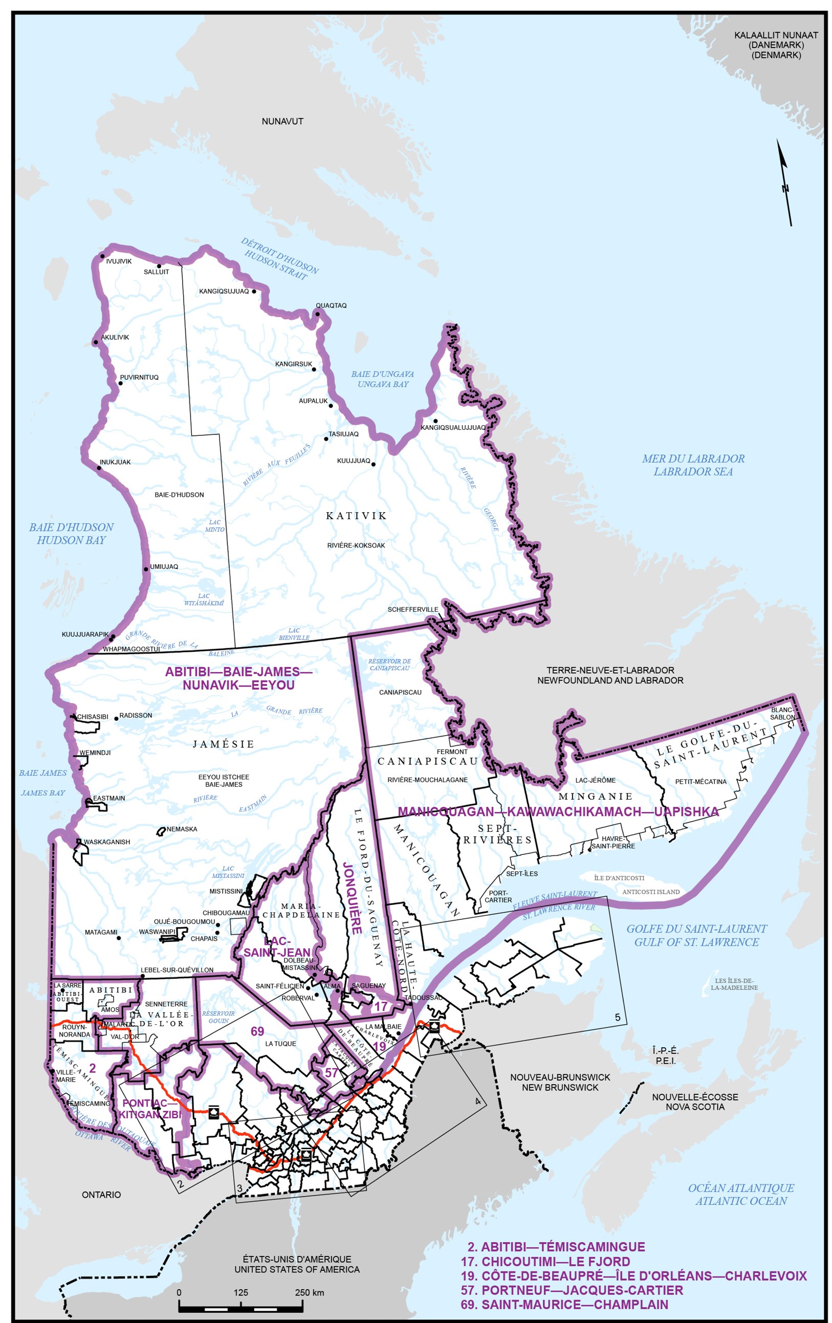
Map 2 - Southwestern Quebec
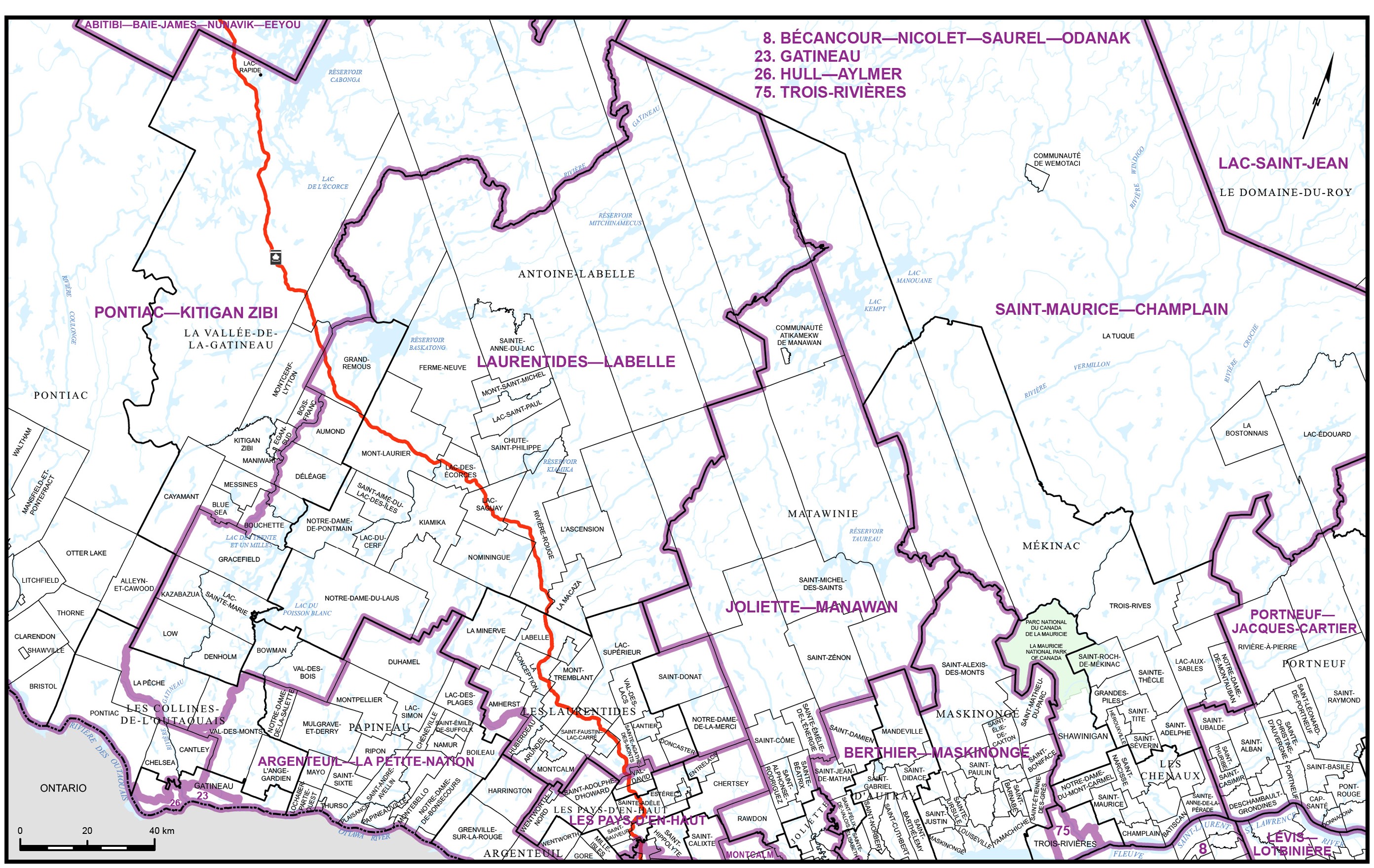
Map 3 - Southern Quebec
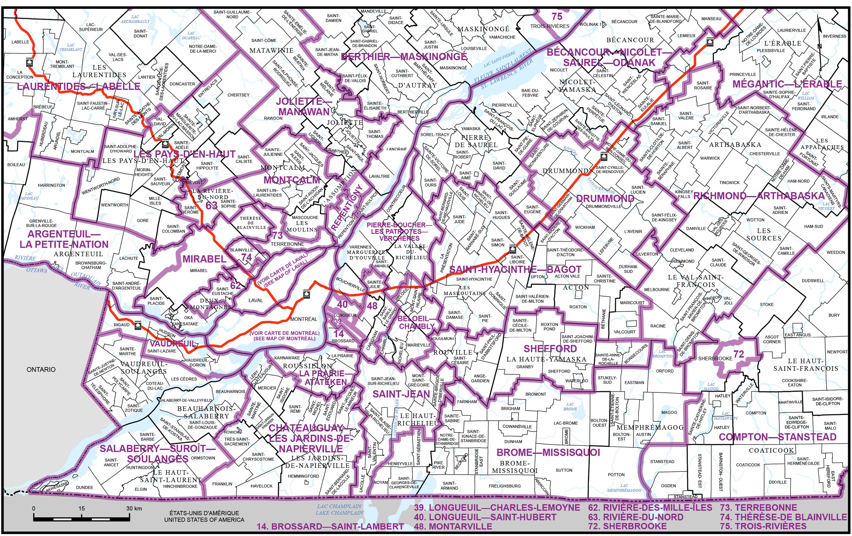
Map 4 - Southeastern Quebec
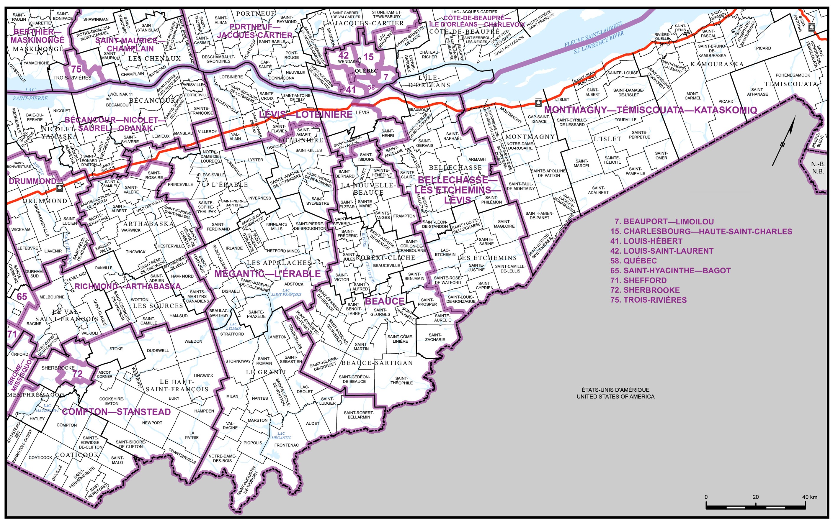
Map 5 - Eastern Quebec
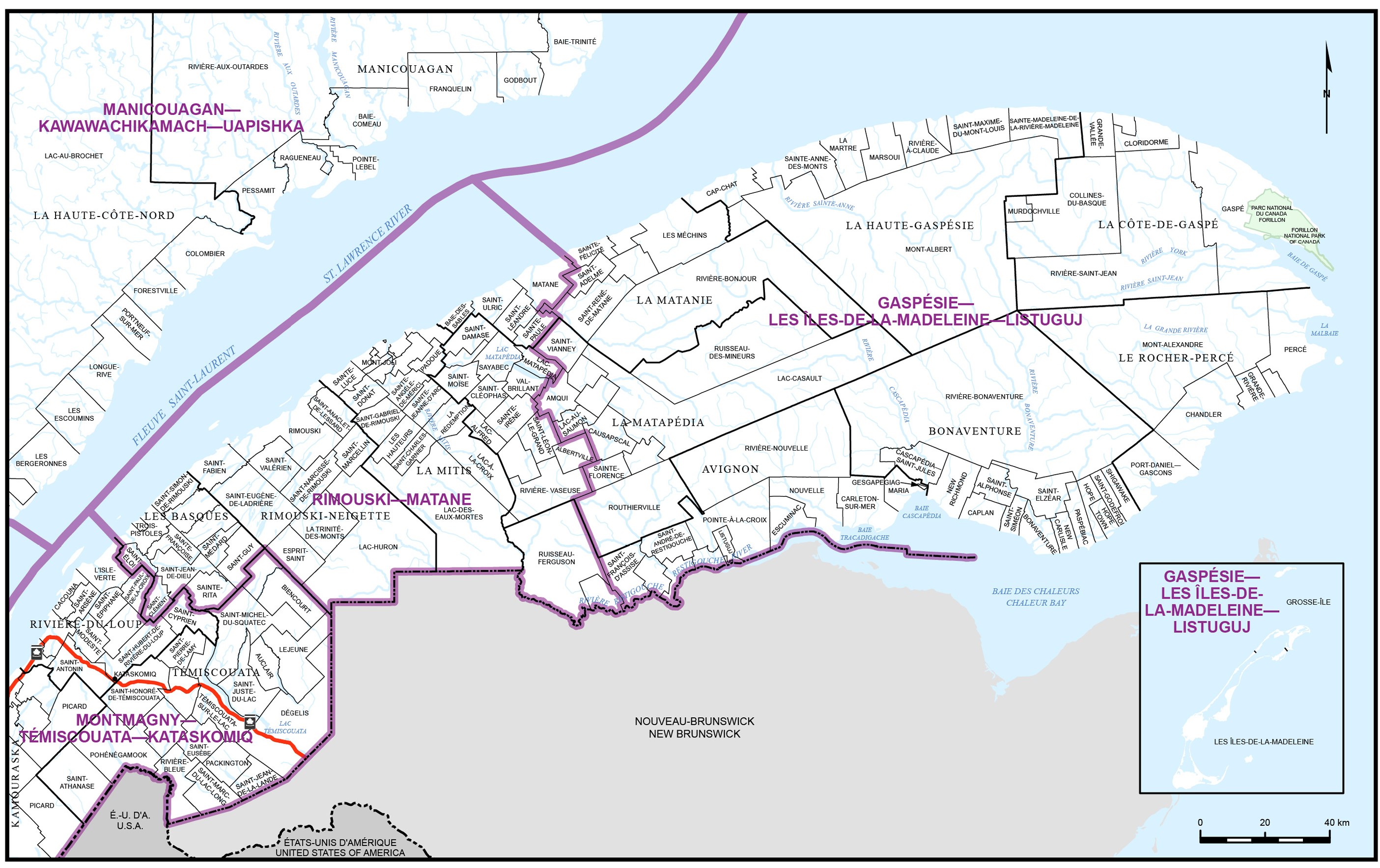
Map 6 - City of L’Assomption
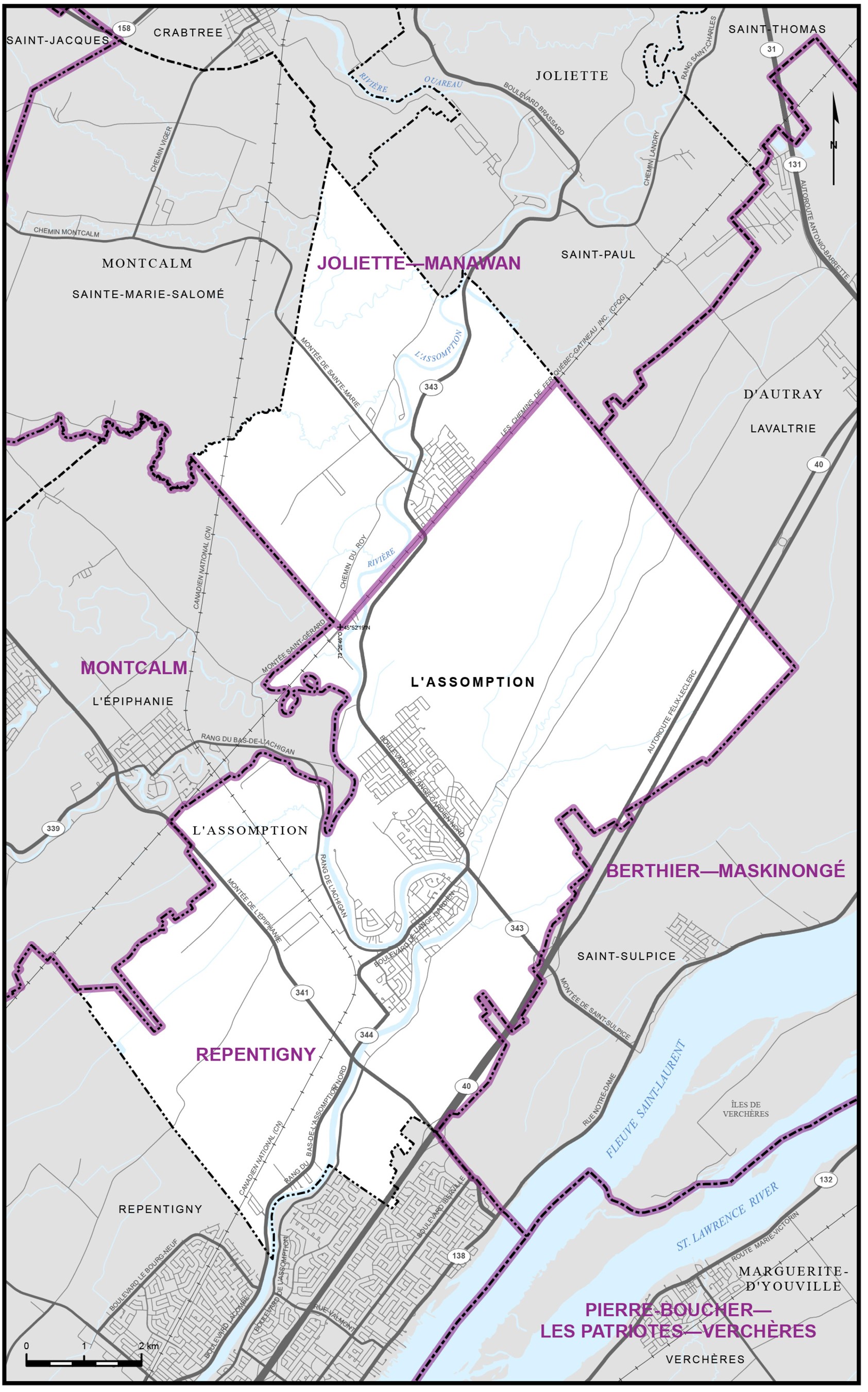
Map 7 - City of Gatineau
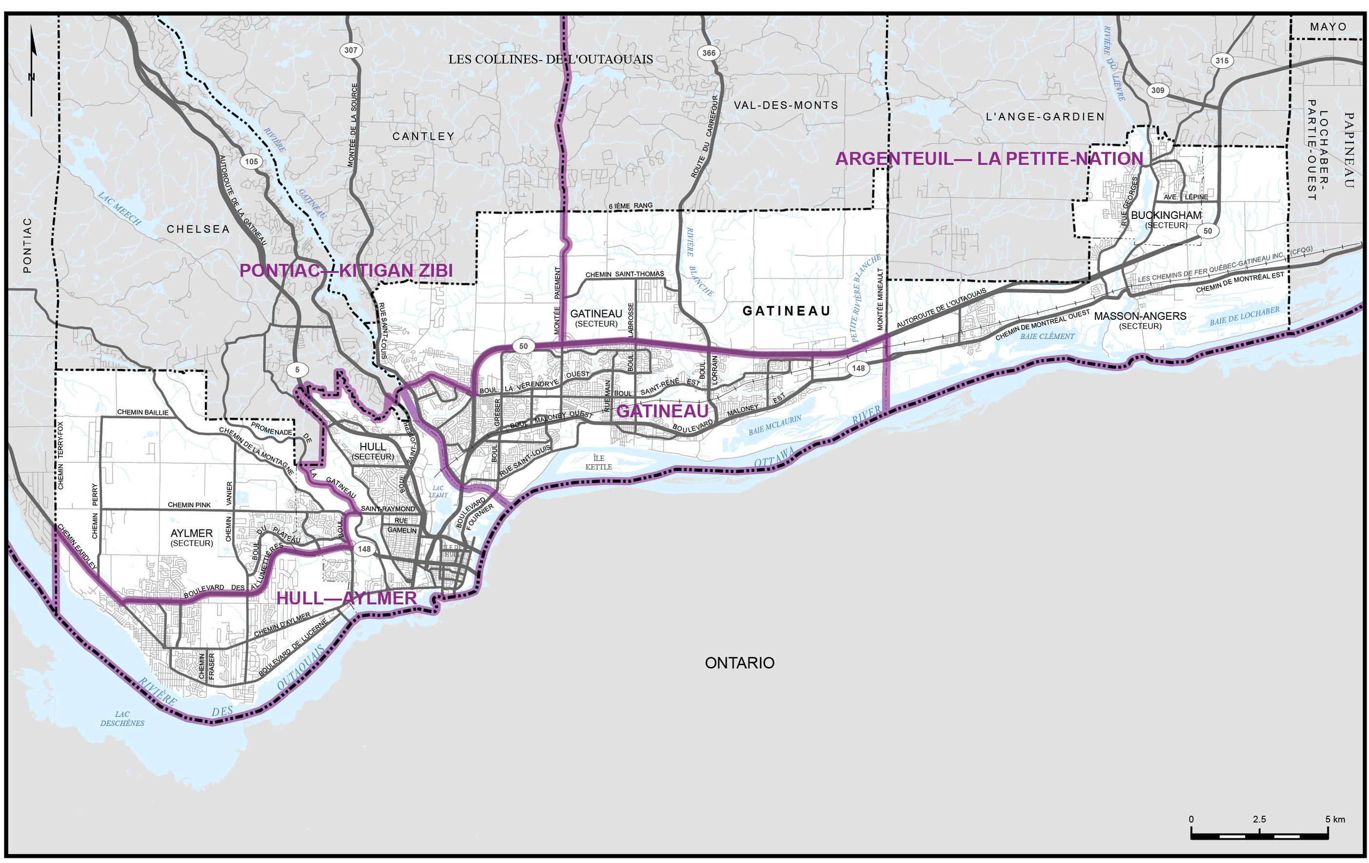
Map 8 - City of Laval
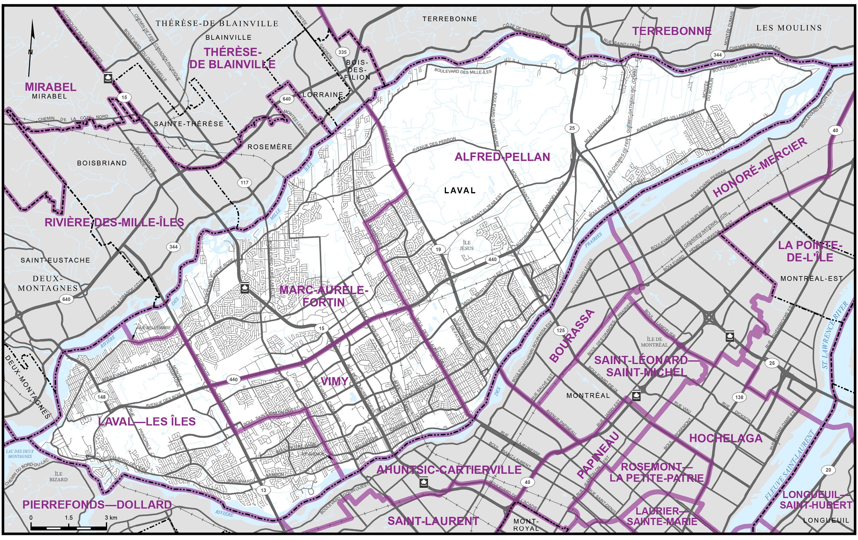
Map 9 - City of Lévis
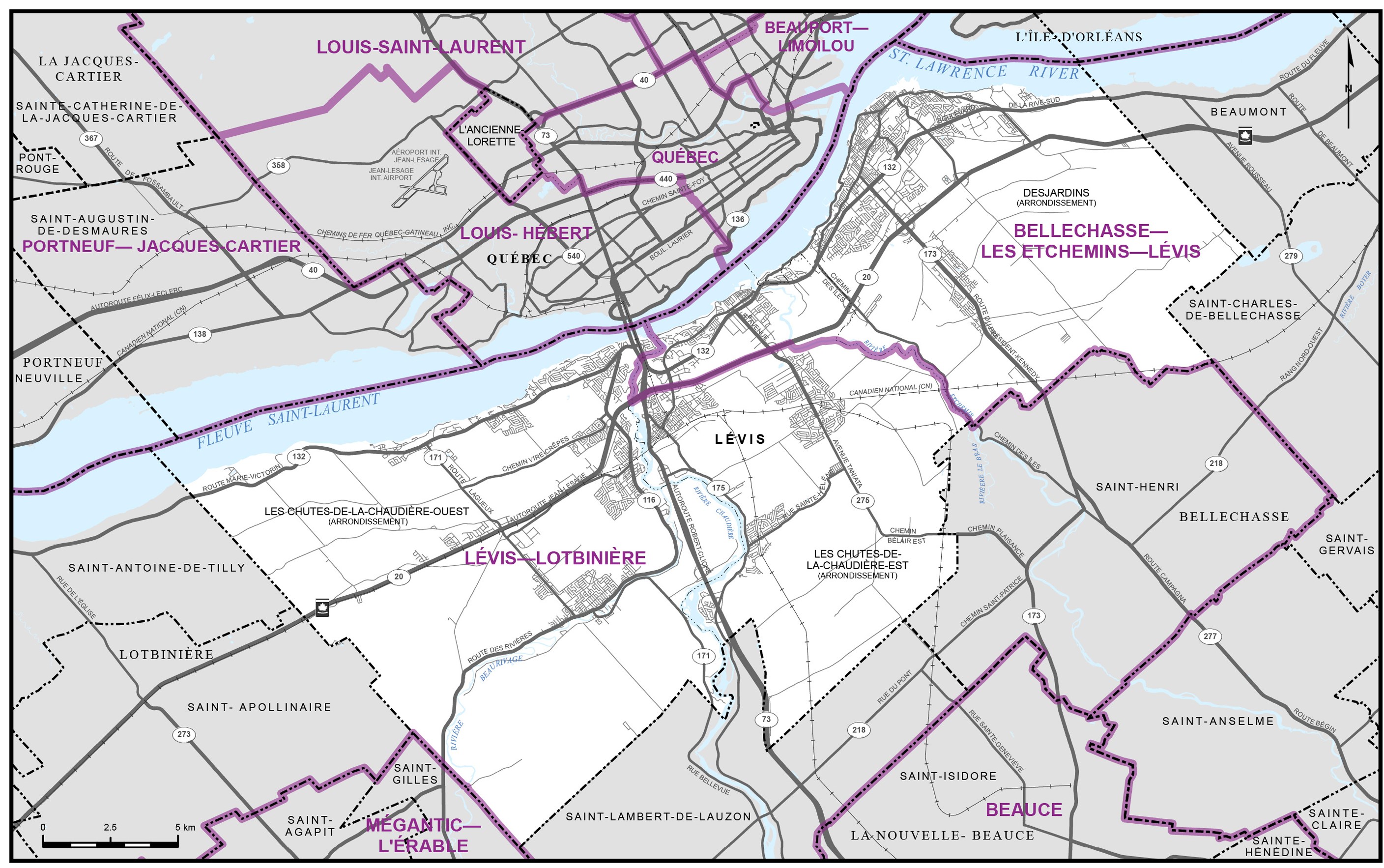
Map 10 - City of Longueuil and Vicinity
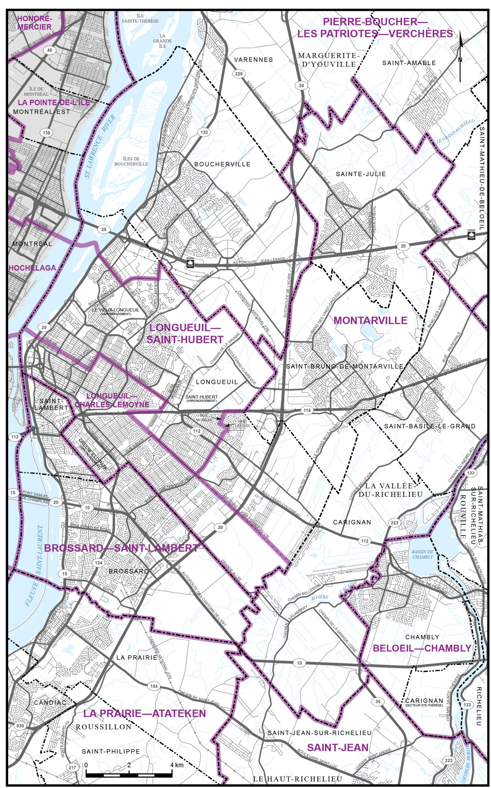
Map 11 - City of Mirabel
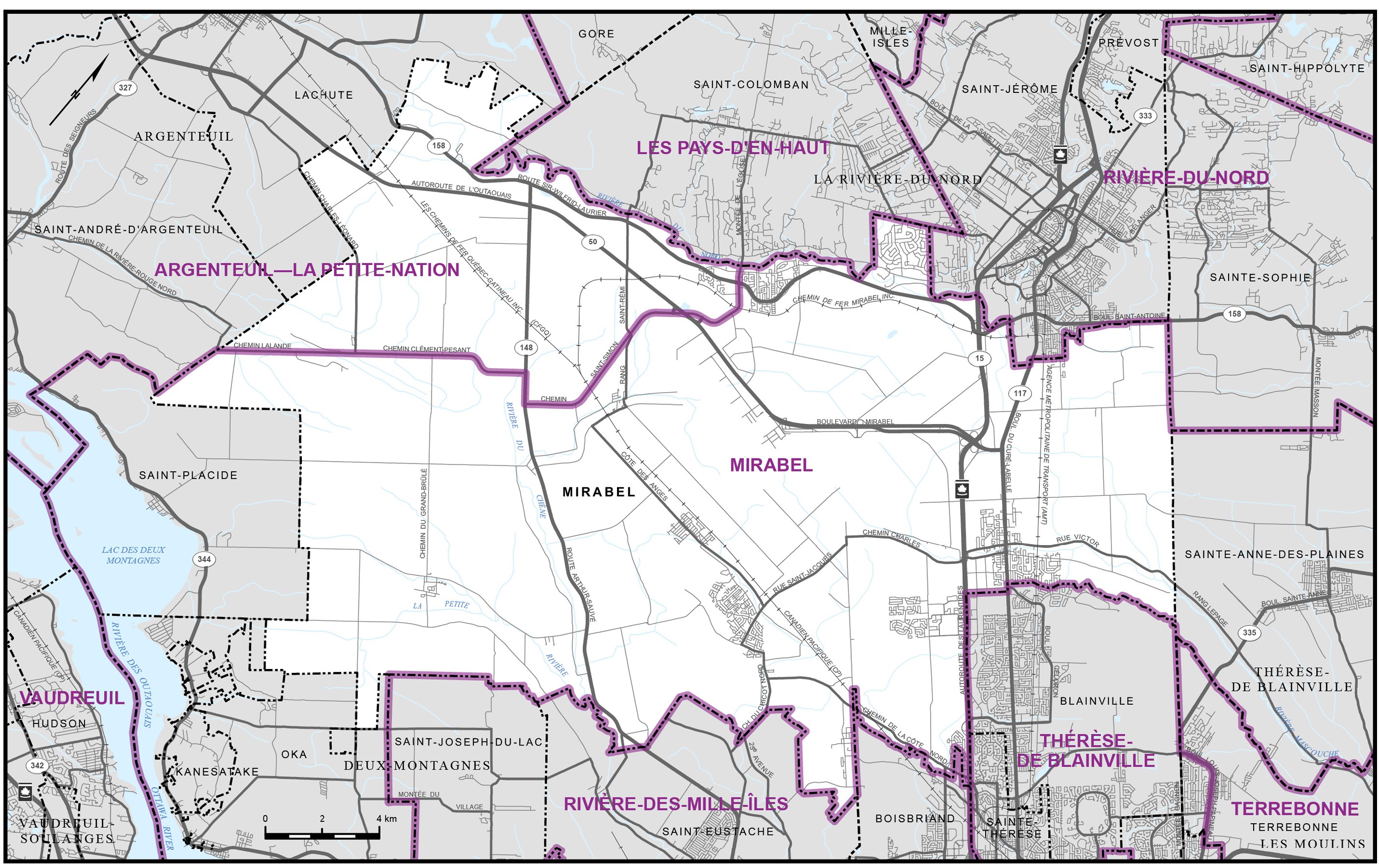
Map 12 - Montréal Island
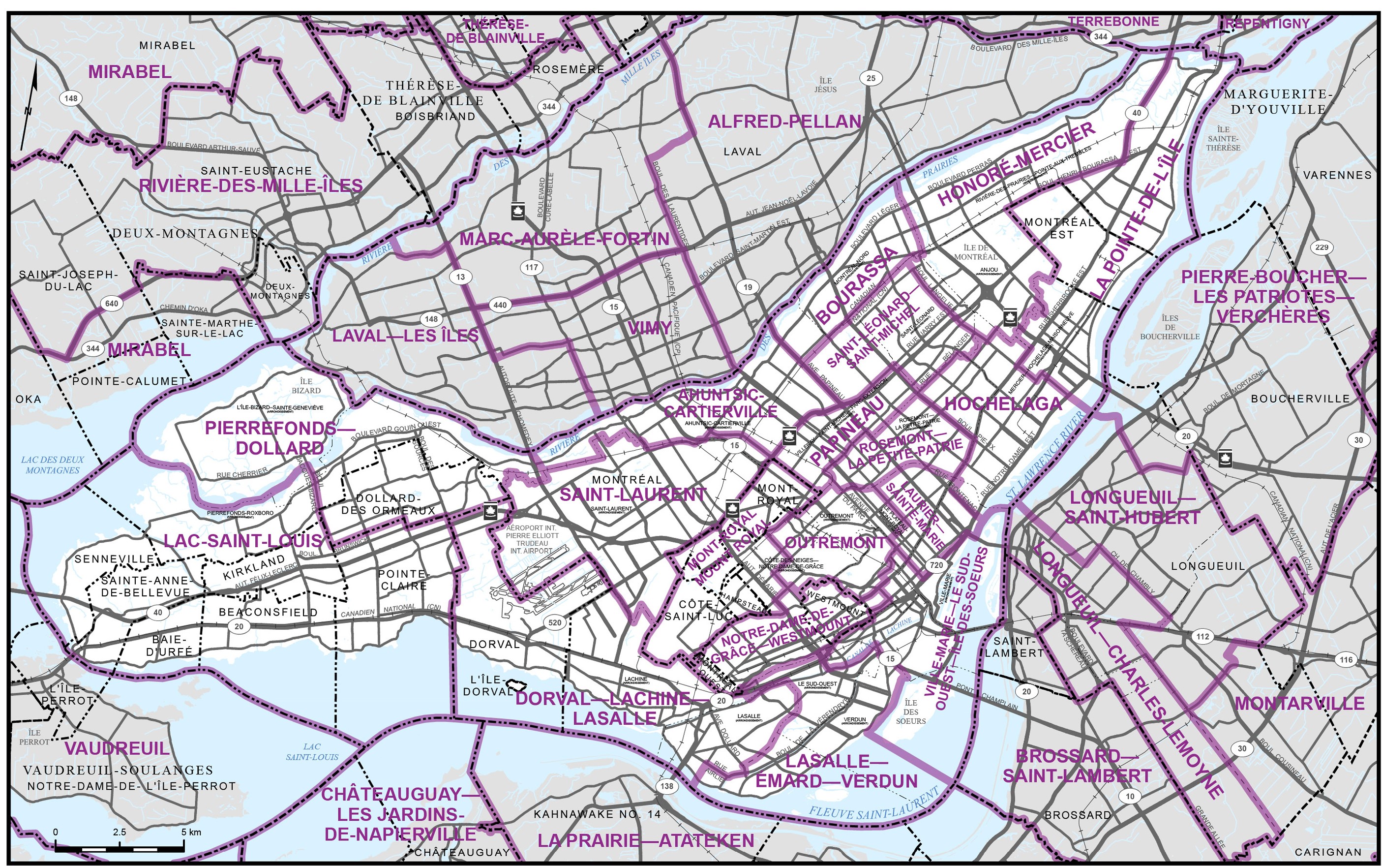
Map 13 - City of Prévost
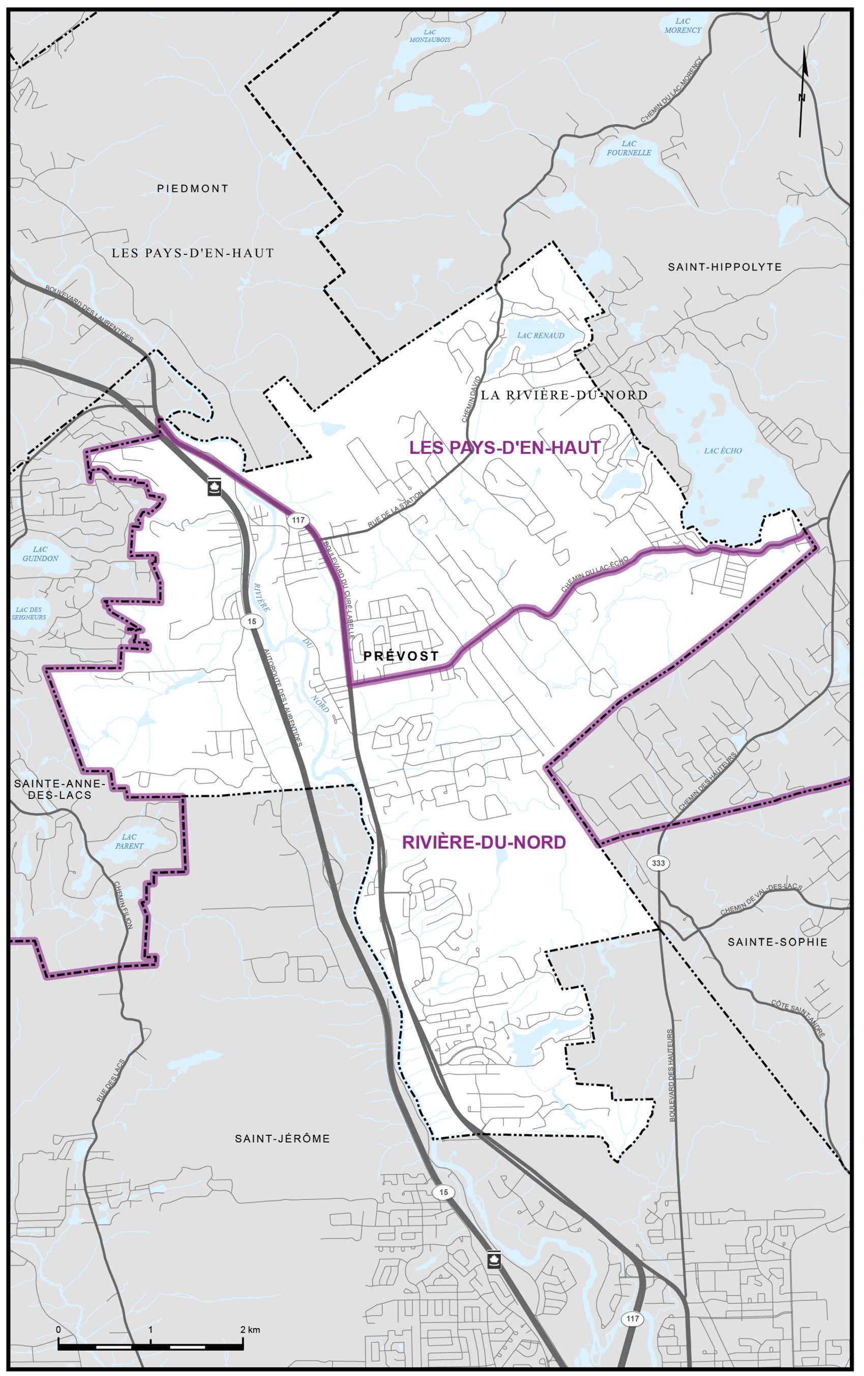
Map 14 - City of Québec
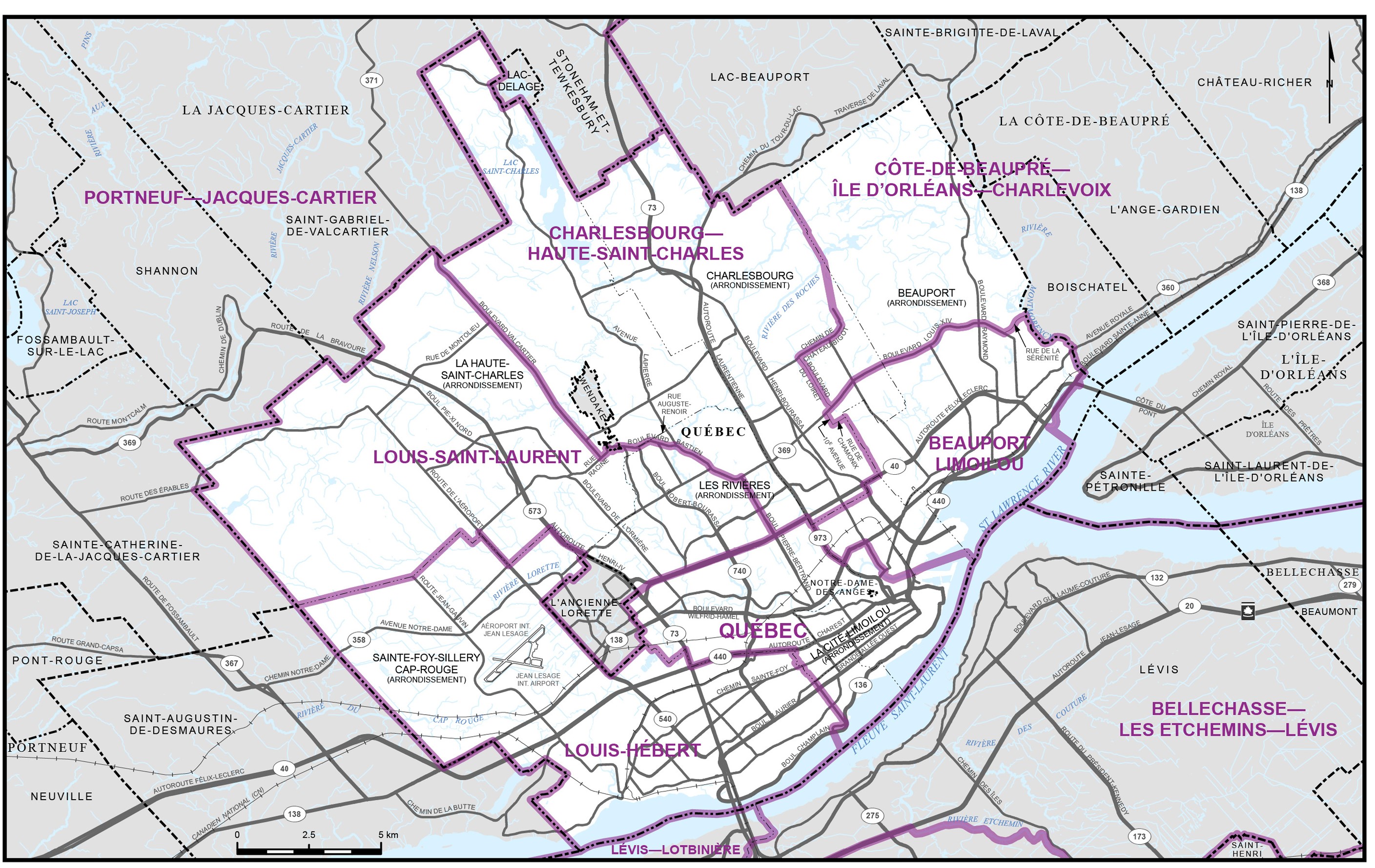
Map 15 - City of Saguenay
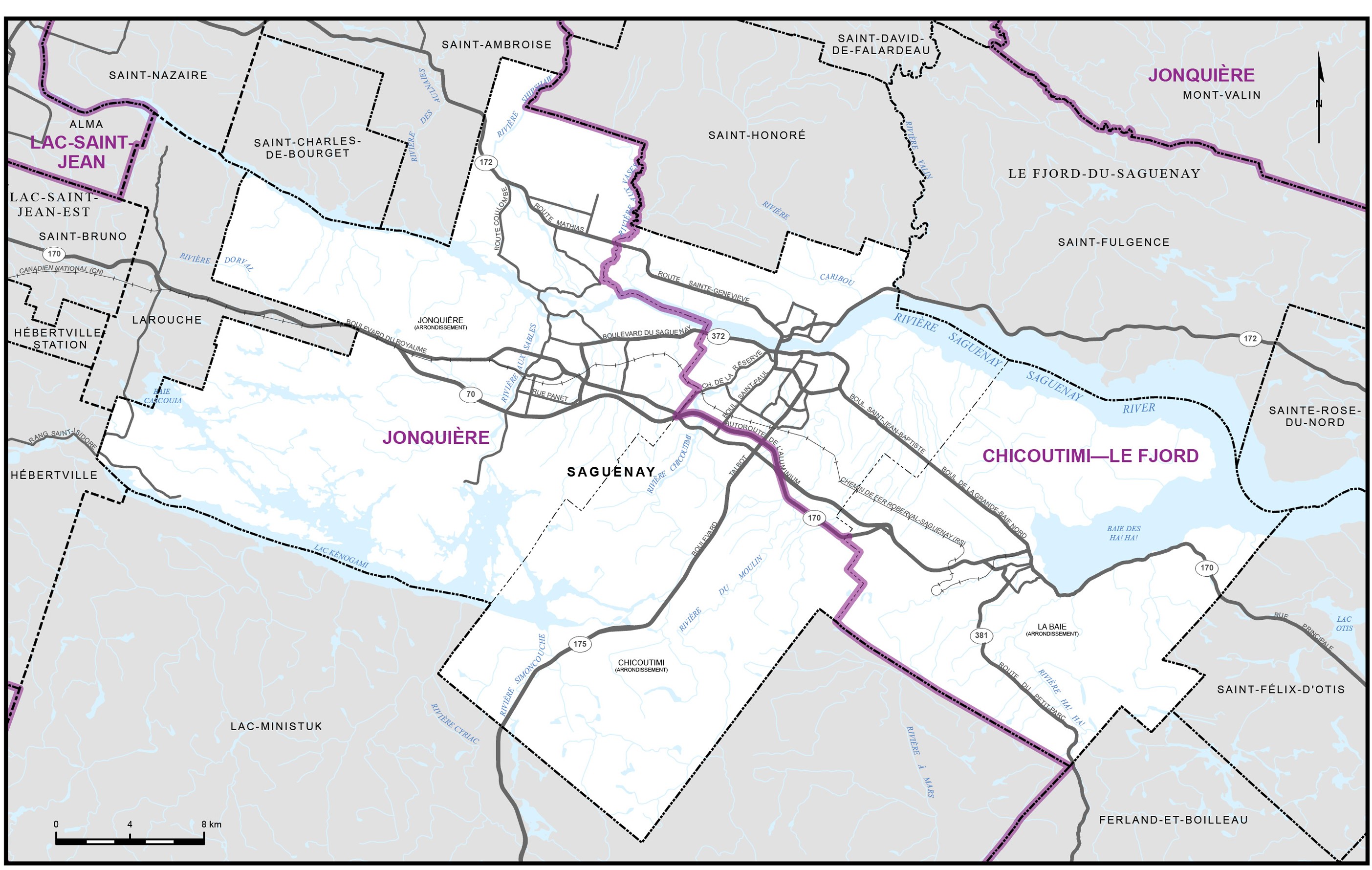
Map 16 - City of Sherbrooke
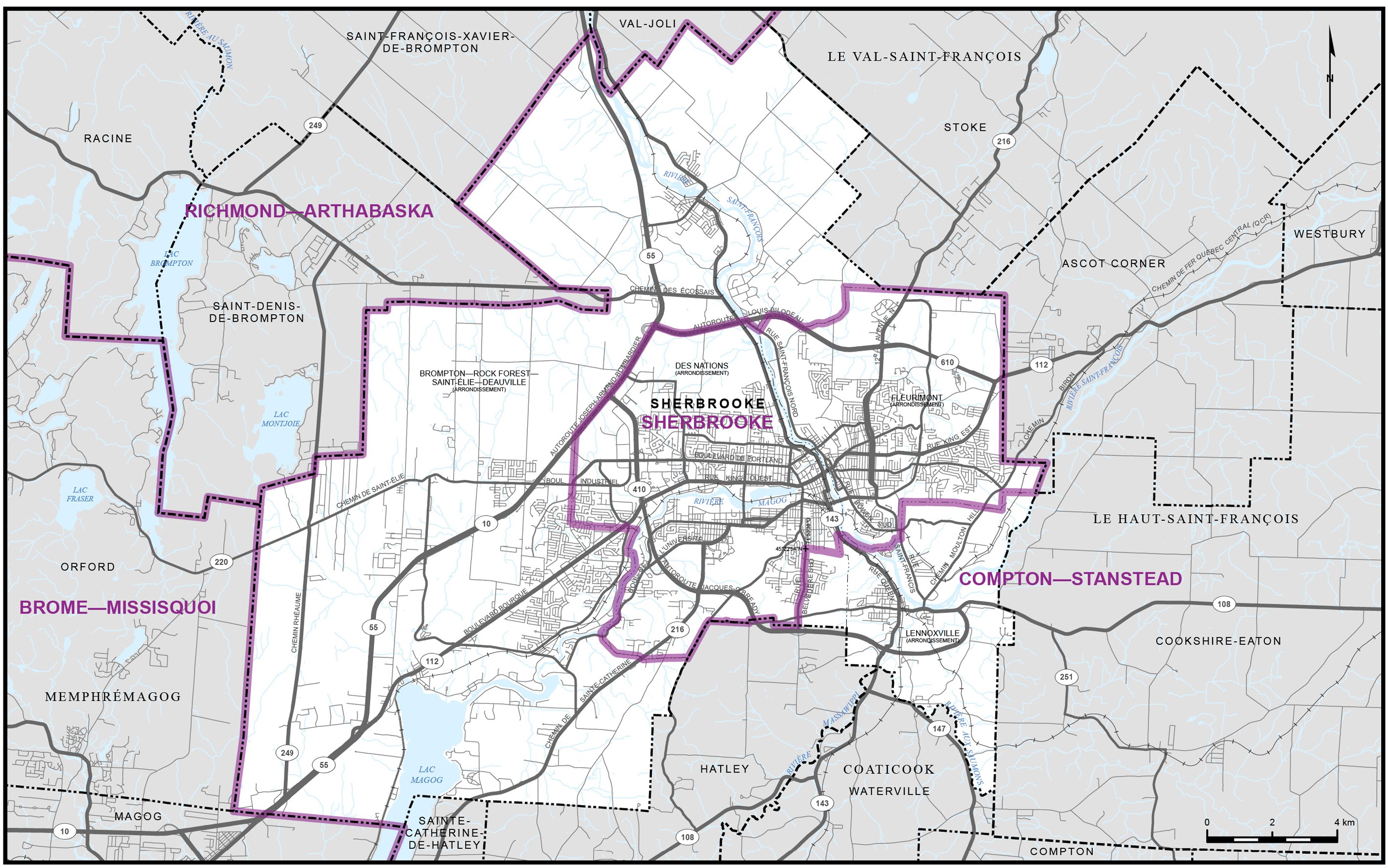
Map 17 - City of Terrebonne
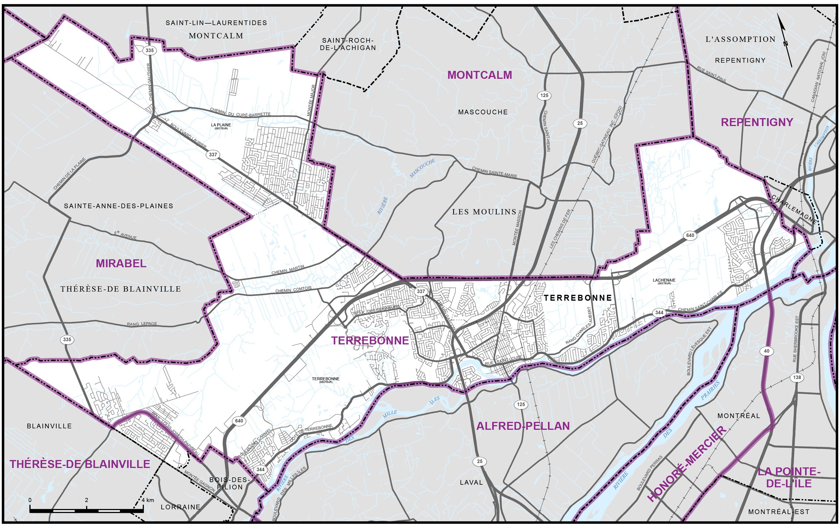
Map 18 - City of Trois-Rivières